 Metadata catalogue
/Biological oceanography/Fish
Type of resources
Available actions
Topics
INSPIRE themes
Keywords
Contact for the resource
Provided by
Years
Representation types
status
-

Explore global fisheries and aquaculture. Understand their status and how impacts are being managed. Learn what improvements are underway, and see what actions seafood stakeholders can take to drive sustainability. FishSource is a publicly available online resource about the status of fisheries, fish stocks, and aquaculture. FishSource compiles and summarizes publicly available scientific and technical information and presents it in an easily interpretable form. FishSource was created in 2007 by Sustainable Fisheries Partnership to provide major seafood buyers with up-to-date, impartial, and actionable information on the sustainability of fisheries and the improvements they need to make to become more sustainable. In 2018, information on aquaculture sources was added to the database to provide FishSource users with a more robust tool that covers all types of seafood production. Although the primary intended audience of FishSource is seafood businesses, other audiences - such as academics, researchers, and non-profit organizations - have also become frequent and welcomed users of FishSource. The information on FishSource is primarily developed and updated by a small team of in-house analysts, but their capacity is recognizably insufficient to maintain complete coverage of all global fisheries. As such, profiles may be incomplete or information may be out of date. The seafood industry and external contributors are invited to help fill any gaps that they consider priorities through our Rapid Assessment Program. FishSource always welcome comments on any of our profiles and encourage an open debate on the sources of information used and our interpretation of the data. Our objective is to use only publicly available sources and fully credit those sources, effectively acting as an inventory of information sources on fisheries and aquaculture.
-

Accredited through the MEDIN partnership, and core-funded by the Department for the Environment, Food and Rural Affairs (Defra) and the Scottish Government, DASSH provides tools and services for the long-term curation, management and publication of marine species and habitats data, within the UK and internationally. Below are a selection of projects, outputs and deliverables that DASSH and the MBA Data Team have been involved in recently. - NE Data Management: DASSH have been contracted by the Marine team at Natural England (NE) to support NE data dissemination. We have been digitising datasets used in Article 17 reporting and helping them input data to Marine Recorder and MEDIN guidelines. In addition, DASSH is running a 2-day workshop with the marine data team in October 2014 on data management and standards. The aims of the workshop are to present MEDIN data guidelines and standards and to run practicals on quality assurance (QA) issues with data, creating MEDIN formatted data, and creation of MEDIN metadata. - MCZ Data Archiving: DASSH staff have been working with Defra, JNCC, Natural England, Cefas and the other MEDIN DAC's in the development and implementation of a strategy for the archiving and dissemination of MCZ survey data. This involves the archives of many terrabytes of data from the survey work undertaken at 127 sites. DASSH is currently working with the other DACs archiving the data from several MCZ sites before taking delivery of the complete survey catalogue. - Non-Natives Data Management: DASSH staff work with other members of the KE team to help deliver the MBA contribution to the GB Non-native Species Information Portal. The data team ensure the validation of records submitted and raise alerts when records of Invasive Non-Native Species of concern and in disseminating information about species distribution via DASSH and the NBN. DASSH staff continue to liaise with organisations to ensure the prompt flow of marine non-native species distribution data to the public domain. The KE team facilitated the identification of two new marine invasive non-native species in 2014 and have subsequently created the identification sheet for these species. Hemigrapsus sanguineus (from volunteer records sent in for identification) and Hemigrapsus takanoi (first recorded by the John Bishop Group survey team). - EMODNet Biology: The Data Team are part of a consortium led by the Flanders Marine Institute (VLIZ) for the biological data component of EMODNet (European Marine Observation and Data Network). The Data Team will lead a work package relating to biological traits and indicator species as identified for Marine Strategy Framework Directive (MSFD) reporting, bringing an additional €130k of funding. - VALMER: The Data Team led a key work package in a £3.7 million (ca. €260k for the MBA) INTERREG project to "Develop, trial and refine methodologies that will be used to quantify and communicate the value (economical, social and environmental) of marine and coastal ecosystem services". The research identified an operational framework to value marine ecosystem services, and which could be used to enhance marine planning and policy decisions.
-
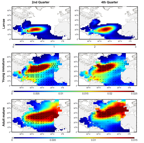
The development of the ecosystem approach and models for the management of ocean marine resources requires easy access to standard validated datasets of historical catch data for the main exploited species. They are used to measure the impact of biomass removal by fisheries and to evaluate the models skills, while the use of standard dataset facilitates models inter-comparison. North Atlantic albacore tuna is exploited all year round by longline and in summer and autumn by surface fisheries and fishery statistics compiled by the International Commission for the Conservation of Atlantic Tunas (ICCAT). Catch and effort with geographical coordinates at monthly spatial resolution of 1° or 5° squares were extracted for this species with a careful definition of fisheries and data screening. In total, thirteen fisheries were defined for the period 1956-2010, with fishing gears longline, troll, mid-water trawl and bait fishing. However, the spatialized catch effort data available in ICCAT database represent a fraction of the entire total catch. Length frequencies of catch were also extracted according to the definition of fisheries above for the period 1956-2010 with a quarterly temporal resolution and spatial resolutions varying from 1°x 1° to 10°x 20°. The resolution used to measure the fish also varies with size-bins of 1, 2 or 5 cm (Fork Length). The screening of data allowed detecting inconsistencies with a relatively large number of samples larger than 150 cm while all studies on the growth of albacore suggest that fish rarely grow up over 130 cm. Therefore, a threshold value of 130 cm has been arbitrarily fixed and all length frequency data above this value removed from the original data set.
-
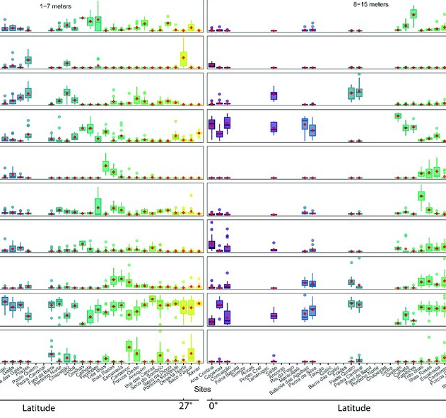
As marine ecosystems are influenced by global and regional processes, standardized information on community structure has become crucial for assessing broad-scale responses to natural and anthropogenic disturbances. Extensive biogeographic provinces, such as the Brazilian Province in the southwest Atlantic, present numerous theoretical and methodological challenges for understanding community patterns on a macroecological scale. In particular, the Brazilian Province is composed of a complex system of heterogeneous reefs and a few offshore islands, with contrasting histories and geophysical-chemical environments. Despite the large extent of the Brazilian Province (almost 8,000 kilometers), most studies of shallow benthic communities are qualitative surveys and/or have been geographically restricted. We quantified community structure of shallow reef habitats from 0° to 27°S latitude using a standard photographic quadrat technique. Percent cover data indicated that benthic communities of Brazilian reefs were dominated by algal turfs and frondose macroalgae, with low percent cover of reef-building corals. Community composition differed significantly among localities, mostly because of their macroalgal abundance, despite reef type or geographic region, with no evident latitudinal pattern. Benthic diversity was lower in the tropics, contrary to the general latitudinal diversity gradient pattern. Richness peaked at mid-latitudes, between 20°S to 23°S, where it was ~3.5-fold higher than localities with the lowest richness. This study provides the first large-scale description of benthic communities along the southwestern Atlantic, providing a baseline for macroecological comparisons and evaluation of future impacts. Moreover, the new understanding of richness distribution along Brazilian reefs will contribute to conservation planning efforts, such as management strategies and the spatial prioritization for the creation of new marine protected areas.
-
Fish assemblages surveyed by using underwater visual censuses (UVC) down to 40 m. Transects were performed between 1997 and 2015 in the Azores, Portugal. All mobile fish were identified to the lowest possible taxon. Dates, geographic coordinates and species recorded are provided. Fish assemblages were surveyed using underwater visual censuses (UVC) down to 40 m. Following standard belt transect surveys (Brock 1954), SCUBA divers sampled transects with 50 m length and 5 m width. All mobile fish were identified to the lowest possible taxon and counted. Sampling sites were chosen based on the general representativeness of the habitat. Transects within sites were selected by stratified random sampling: different transects were done in each dive without replicating the depth strata (every 10 m) or overall bottom type or crossing transects during a single dive or day. UVCs were conducted in the scope of projects CLIPE (FCT—Praxis XXI/3/3.2/EMG/1957/95), MARÉ (LIFE B4-3200/98-509), MAREFISH (FCT-POCTI/ BSE/41207/2001), OGAMP (INTERREG IIIb/MAC/4.2/A2 2001), MARMAC (INTERREGIIIb-03/MAC/4.2/A1 2004), EmpaFish (EC-FP6, SSP8-006539), MareFish (FCT, POCTI/BSE/41207/2001), MoniZEC (FRC - M2.1.2/I/018/2011)
-
%20Raw%20Echosounder%20data.jpg)
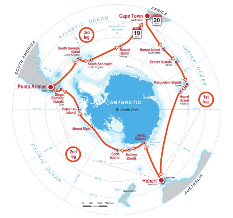
AMT25: The overall aim of the Atlantic Meridional Transect programme is: to quantify key biogeochemical and ecosystem processes and their inherent variability over extended time and spatial scales in the Atlantic Ocean. This is achieved by executing an annually repeated meridional transect through contrasting oceanic provinces, ranging from oligotrophic deserts, to highly productive shelf seas. Specific objectives: - To quantify the nature and causes of ecological and biogeochemical variability in planktonic ecosystems; - To quantify the effects of this variability on nutrient cycling, on biogenic export and on air-sea exchange of climate active gases; - To construct multi-decadal, multidisciplinary ocean time-series which are integrated within a wider "Pole-to-pole" observatory concept; - To provide essential sea-truth validation for current and next generation satellite missions; - To provide essential data for global ecosystem model development and validation; - To provide a valuable, highly sought after and unique training arena for the next generation of UK and international oceanographers. JR864: The oceanographic research ship RRS James Clark Ross attempted to physically and biologically characterise Ascension Island's shelf from 14th-18th October 2015. Multibeam sonar swath was used to generate the first open-access, high resolution mapping of Ascension Island's seabed between 100-1100m depth. These data was used to determine seabed profile and rugosity characteristics. Seabed substratum was investigated using a benthic camera lander (SUCS) and water column physico-chemistry was gained using CTD. The SUCS provided 500 photographs and video clips of benthos from 21 site/depth combinations, which showed a wide disparity in richness and density of biodiversity. These were ground-truthed by targeted Agassiz trawl samples to collect vouchers specimens for morphological and genetic identification. Specimens collected were photographed, fixed and then preserved in 96% ethanol for later genetic analyses. Preliminary analysis of the biodiversity captured was undertaken in the Conservation Department building, Georgetown, Ascension Island and indicated new records for the Island including first records of brachipods.
-
%20sub-facility.jpg)
The IMOS Bio-Acoustic Ship Of Opportunity (BASOOP) sub-facility is part of a major international effort that aims to develop a global ocean Mid-trophic Automatic Acoustic Sampler (MAAS) being proposed as part of the CLimate Impacts on Oceanic TOp Predators (CLIOTOP) program. This SOOP dataset covers the Indian Ocean and waters south and east of Australia and across to New Zealand. BASOOP commenced on the 1st of July 2010 to collect underway acoustic data while vessels are transiting ocean basins. At present, nine vessels are participating in the BASOOP program. Six are commercial fishing vessels that have agreed to record data during transits to and from fishing grounds. The remaining three are scientific research vessels collecting underway acoustic data during transits and science operations. Bio acoustic signals allow understanding how mid-water prey species (known collectively as micronekton) such as small fish, squid, krill and jellyfish are distributed. Micronekton form the core of the ocean food web, transferring energy from primary producers at the ocean surface to top predators such as tunas, billfish, sharks, seals and seabirds. The mass and distribution of micronekton reflects broad-scale patterns in the structure and function of the ocean, as well as the dynamics of marine ecosystems. The mapping complements established observing systems such as physical sampling of ocean currents, surveys of ocean chemistry and biology (plankton and zooplankton), and electronic tagging and tracking of large marine fish and mammals. The combined information greatly enhances the capacity of marine scientists to monitor shifts in food availability over time, assisting in the monitoring and modelling of oceanography, ecosystems, fisheries and climate change, and in understanding the behaviour of top predators. Data Collection: All BASOOP vessels collect 38 kHz acoustic data from either Simrad EK60, ES60 (split beam) or ES70 echosounders. In all cases the 38 kHz echosounders are connected to Simrad ES38B transducers. This is a narrow-beam (7 o) ceramic transducer with good long term stability and manufacturer supplied calibration parameters. Research vessel Southern Surveyor also collects concurrent acoustic data at 12 and 120 kHz. The research vessel Aurora Australis collects concurrent acoustic data at 12, 120 and 200 kHz. The primary data-type recorded from the vessel-mounted echosounder systems is georeferenced calibrated water column volume backscatter, Sv [dB re 1 m-1], (Maclennan et al. 2002) . The raw acoustic data is post processed to (i) identify on-transit data and prioritise processing, (ii) apply calibration offsets, (iii) apply semi-automated filters to identify and reject bad data and (iv) create output stored in netCDF format, mean echointegrated Sv for cells of 1000 m distance and 10 m height. A full metadata record is also stored in each netCDF file. Reference: *Maclennan, D.N., Fernandes, P.G., and Dalen, J. 2002. A consistent approach to definitions and symbols in fisheries acoustics. ICES Journal of Marine Science: Journal du Conseil 59(2): 365.
-
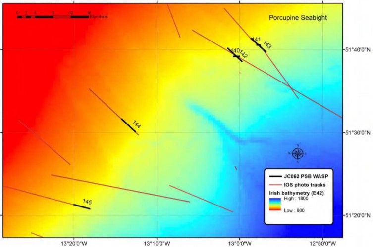
While there has been an increase in the understanding of how climate and surface processes affect deep-sea communities, the ability to understand these links further is thought to be limited by sampling error from undetected habitat heterogeneity (i.e. irregular or uneven habitat distributions). Features like hills, valleys, depressions, small rock outcrops, and biogenic mounds add to habitat complexity, but links between such features and the animals that live among them are very poorly resolved in abyssal plain habitats using current methods. Our efforts aimed to address the following objectives: 1. We serviced the PAP1, PAP3 and Bathysnap long-term observatory systems. These systems provide data that is critical in understanding connections between climate, surface ocean processes, and change in deep-sea habitats. 2. We ecologically surveyed the region around the PAP - Sustained Observatory (SO) to understand how the topography of the seabed alters the abundance and distribution of fauna in abyssal habitats. This surveying employed the use of acoustic mapping, megacoring, box coring, a baited camera lander, towed cameras, an amphipod trap, and trawling. 3. We also conducted a number of specialised research studies including research on low bandwidth observatory telecommunications, phytoplankton community structure, bioluminescence, the impacts of crude oil on benthic sediment communities, and the effects of pressure on photoreceptors, and the potential impacts of trawling on slope habitats in the Porcupine Seabight. These studies took advantage of the equipment above with the addition of conductivity temperature and depth (CTD) rosette casts and laboratory facilities. The cruise achieved its main objectives including servicing of mooring infrastructure, ecological mapping of the PAP area, and a survey of potentially impacted sponge communities on the N PSB slope. We were favoured by good weather and what proved to be mainly minor issues with winches and other equipment. We surveyed three abyssal plain areas and four hill areas within the greater vicinity of the PAP-SO. At all of these seven sites we conducted a WASP transect and at least 5 megacore deployments. At all seven survey sites except PAP Cent. we conducted a baited camera and ampipod trap deployment as the deposition of ballast at PAP Cent. was to be avoided. At the PAP Cent. site we also conducted series of five box core deployments. Details on specific activities, their objectives and initial results are provided below including ancillary activities conducted at Goban Spur and the Porcupine Seabight.
-
%20Raw%20Echosounder%20data.jpg)
The overall aim of the Atlantic Meridional Transect programme is: to quantify key biogeochemical and ecosystem processes and their inherent variability over extended time and spatial scales in the Atlantic Ocean. This is achieved by executing an annually repeated meridional transect through contrasting oceanic provinces, ranging from oligotrophic deserts, to highly productive shelf seas. The specific objectives of AMT are: - To quantify the nature and causes of ecological and biogeochemical variability in planktonic ecosystems; - To quantify the effects of this variability on nutrient cycling, on biogenic export and on air-sea exchange of climate active gases; - To construct multi-decadal, multidisciplinary ocean time-series which are integrated within a wider “Pole-to-pole” observatory concept; - To provide essential sea-truth validation for current and next generation satellite missions; - To provide essential data for global ecosystem model development and validation; - To provide a valuable, highly sought after and unique training arena for the next generation of UK and International oceanographers.
-
These data consist of raw echosounder observations collected during ACE (Leg1-Leg3) using an EK80 WBT operating at 12.5 kHz. The instrument was calibrated at South Georgia during the expedition (Leg 3) and corrections were applied prior to calculation of the volume backscattering strength (Sv). The signal-to-noise ratio (SNR) was analysed and was deemed very poor at depths greater than 1000 m. Therefore, only data collected between the transducer depth (8.4 m) and 1000 m were archived. Sv values within this depth range that had poor SNRs (<2) were deemed to be bad data and set to a value of NA. Observations were made using a pulse duration of 16.384 ms (c. 24 m) and are therefore not suitable for fine-scale studies (e.g. analysis of krill swarms). They are more suited to studies relating to large-scale biological features such as deep scattering layers.