 Metadata catalogue
XLS, XLSX
Type of resources
Available actions
Topics
Keywords
Contact for the resource
Provided by
Years
Formats
-
Ages obtained through the 40Ar/39Ar method for basalt samples with the Nautile submersible along the axis of the Mid-Atlantic Ridge south of the Romanche transform fault. Major elements measurements were performed on the same samples. For a complete description of the method and discussion of results, please refer to the Grenet et al. 2023 article.
-
Sea fans (order : Alcyonacea) are the most remarkable and easily identifiable species of the subtidal hard substrate communities (Gili and Ros, 1985). From an ecological point of view, sea fans play an essential role (Gili and Coma, 1998) by increasing the biomass and the diversity of hard substrates (Mitchell et al, 1992; Ballesteros, 2006) via an umbrella species role providing habitat for small epifauna and a refuge for many fish (Ross and Quatrini, 2007). When their density is high enough, they form animal forests (sensu Rossi et al 2017) and become engineering species by modifying the level of turbulence and therefore of sedimentation of propagules in the benthic boundary layer (Chamberlain and Graus, 1975). In the shallow rocky habitats of the Mediterranean, five species of sea fans dominate: the white gorgonian Eunicella singularis (Esper, 1791), the orange gorgonian Leptogorgia sarmentosa (Esper, 1789), the yellow gorgonian Eunicella cavolinii (Koch, 1887), the red gorgonian Paramuricea clavata (Risso, 1826), and the red coral Corallium rubrum (Linnaeus, 1758). Some of these species, characterized by long life span, have been included in the management plans of the Gulf of Lion Marine Protected Areas, with surveys for the monitoring of the demographic structure of E. Singularis (Réserve Naturelle Marine de Cerbère-Banyuls, Aire Marine Protégée Agathoise) and C. rubrum (Réserve Naturelle Marine de Cerbère-Banyuls, Parc Marin de la Côte Bleue). In parallel with these management-related surveys, some scientific studies on the demographic structure and ecology of P. clavata, E. singularis and C. rubrum, with the aim of documenting mass mortality events (Cerrano et al. al., 2000, Garrabou et al., 2001) have been undertaken in the Parc Marin de la Côte Bleue, in the Parc National de Port-Cros, along the Côte Vermeille and Cap de Creus coast and in the Cinque Terre National Park (Garrabou and Harmelin, 2002, Torrents et al., 2005 ; Linares et al. 2008 Linares et al., 2010 ; Santangelo et al., 2011; Gori et al., 2011a ; Gori et al. 2011b; Rossi et al., 2008). The present database gathers two extensive inventory of sea fans populations performed between 2013 and 2015 in the Gulf of Lion and between 2018 and 2019 in the Ligurian Sea. The same protocol was applied to estimate the population density of the five species in 585 stations. The 585 stations were defined a priori on a regular mesh mapping the main hard-bottom substrate units of the Gulf of Lion (Côte Bleue, Plateau des Aresquiers, Plateau du Cap d'Agde, Cap Leucate, Côte Vermeille), and surrounding the ports of Toulon, La Spezia and Bastia (Figure 1). The spacing between stations was varied from 100m to 800 m according to bathymetry steepness. Each station was geo-referenced from the surface and located on the sea bed with a mooring. Counts of individuals of the five species were made by scuba divers trained to species identification in four quadrats (1m x 1m), positionned at 5 m from the mooring along the sea bed, in the four cardinal directions. In total, the sampling required 1500 dives. References Ballesteros E. 2006. Mediterranean coralligenous assemblages: a synthesis of present knowledge Oceanography and Marine Biology: An Annual Review 44, 123-195 Carpine C, Grasshoff M. 1975. Les gorgonaires de la Mediterranee. Bull Inst Oceanogr Monaco 71:1–140 Cerrano, C., Bavestrello G., Bianchi C.N., Cattaneo R. Vietti, S. Bava, C. Morganti, C. Morri, P. Picco, G. Sara S. Schiaparelli S. Siccardi A. & Sponga, F. 2000. A catastrophic mass-mortality episode of gorgonians and other organisms in the Ligurian Sea (Northwestern Mediterranean), summer 1999. Ecology Letters 3: 284–293. Chamberlain J.J. A., Graus, R.R. 1975. Water Flow and Hydromechanical Adaptations of Branched Reef Corals. : Bulletin of Marine Science 25 (1): 112-125 Garrabou J., Perez T., Sartoretto S., Harmelin J.G., 2001. Mass mortality event in red coral Corallium rubrum populations in the Provence region (France, NW Mediterranean). Mar Ecol Prog Ser 217:263–272 Garrabou J., Harmelin G. 2002. A 20-year study on life-history traits of a harvested long-lived temperate coral in the NW Mediterranean: insights into conservation and management needs. J Anim Ecol 71:966–978 Gili, J.M., & Ros, J. 1985. Study and cartography of the benthic communities of the Medes Islands (NE Spain). Marine Ecology 6, 219–238. Gili J.M. and Coma R. 1998. Benthic suspension feeders: their paramount role in littoral marine substrates. TREE 13 (8): 316-321 Gori, A., Rossi, S., Linares, C., Berganzo, E., Orejas, C., Dale, M. & Gili, J.M. 2011a. Size and spatial structure in deep versus shallow populations of the Mediterranean gorgonian Eunicella singularis (Cap de Creus, Northwestern Mediterranean Sea)” Marine Biology, DOI: 10.1007/s00227-011-1686-7 Gori A., Rossi S., Berganzo E., Pretus J.L., Dale M.R.T., Gili J.M. 2011b. Spatial distribution patterns of the gorgonians Eunicella singularis, Paramuricea clavata and Leptogorgia sarmentosa (Cape of Creus, Northwestern Mediterranean Sea). Mar Biol 158:143-158 Linares C, Coma R, Garrabou J, Diaz D, Zabala M. 2008. Size distribution, density and disturbance in two Mediterranean gorgonians: Paramuricea clavata and Eunicella singularis. J Appl Ecol 45:688–699 Linares C., Bianchimani O., Torrents O., Marschal C., Drap P., Garrabou J., 2010. Marine Protected Areas and the conservation of long-lived marine invertebrates : the Mediterranean red coral. Marine Ecology Progress Series 402: 69-79. Mitchell, N. D., Dardeau, M. R., Schroeder,W. W., Benke, A. C. 1992. Secondary production of gorgonian corals in the northern Gulf of Mexico. Mar Ecol. Prog. Ser. 87: 275-281 Ross S., Quattrini A. 2007. The fish fauna associated with deep coral banks off the southeastern United States. Deep Sea Research I (54): 975-1007. Rossi S, Bramanti L, Gori A, Orejas C. 2017. An Overview of the Animal Forests of the World. In book: Marine Animal Forests, pp.1-26. SPRINGER.[DOI: 10.1007/978-3-319-17001-5_1-1] Santangelo G., Bramanti L., Rossi S., Tsounis G., Vielmini I., Lott C., Gili J.M. 2011. Spatial patterns of variation in recruitment and post-recruitment processes of the Mediterranean precious gorgonian coral Corallium rubrum. Journal of Experimental Marine Biology and Ecology. DOI: 10.1016/j.jembe.2011.10.030 Torrents O., Garrabou J., Marshal C., Harmelin J.G., 2005. Age and size at first reproduction in the commercially exploited red coral Corallium rubrum (L.) in the Marseilles area (France, NW Mediterranean). Biol Conserv 121: 391–397 Rossi S., Tsounis G., Orejas C., Padrón T., Gili J.M., Bramanti L., Teixidó N. and Gutt J. 2008. Survey of deep-dwelling red coral (Corallium rubrum ) populations at Cap de Creus (NW Mediterranean). Marine Biology 154 (3): 533-545.
-
Disrupting North Atlantic Deep Water (NADW) ventilation is a key concern in climate projections. We use (sub)centennially resolved bottom water d13C records that span the interglacials of the last 0.5 million years to assess the frequency of and the climatic backgrounds capable of triggering large NADW reductions. Episodes of reduced NADW in the deep Atlantic, similar in magnitude to glacial events, have been relatively common and occasionally long-lasting features of interglacials. NADW reductions were triggered across the range of recent interglacial climate backgrounds, which demonstrates that catastrophic freshwater outburst floods were not a prerequisite for large perturbations. Our results argue that large NADW disruptions are more easily achieved than previously appreciated and that they occurred in past climate conditions similar to those we may soon face.
-
Pialassa Baiona is a temperate coastal lagoon connected with the Northwestern Adriatic Sea (44° 280 N and 44°310 E). Sediment cores and surface sediments were collected in two habitats within Pialassa Baiona: a) a salt marsh habitat characterized by the presence of saltmarsh vegetation, and b) a human impacted habitat close to anthropogenic source inputs. Cores were sampled by inserting one cylindrical Plexiglas hand corer (5-cm diameter, 50 cm long) into the sediment to a depth of 20-25 cm, and surface sediment samples (0–5 cm) were collected with a stainless-steel grab sampler. The cores were extruded in the field, sectioned into 1‐2 cm intervals, and analyzed for total organic carbon (OC), total nitrogen (TN), carbon isotope ratio (δ13C) and dry bulk density (upper 20 – 25 cm) and analyzed for organic carbon (OC), total nitrogen (TN), carbon isotope ratio (δ13C) and dry bulk density. Organic carbon (OC), total nitrogen (TN), and carbon isotopes (δ13C = [(13C/12C)sample/(13C/12C)standard − 1] × 1,000) were measured in sediment cores and surface sediments using a using a FINNIGAN Delta Plus XP mass spectrometer directly coupled to Thermo Fisher FLASH 2000 CHNS Elemental Analyzer. OC and TN content was expressed as the weight percentage of dried sediment, and carbon isotope results were reported in the standard delta notation with respect to the Vienna Pee Dee Belemnite. A ‘three-end member’ mixing model was used to estimate the relative contribution of the different organic matter (OM) sources: marine phytoplankton (FM), riverine-estuarine phytoplankton (FRE), and C3 saltmarsh plant material (FSM): δ13Csample = δ13CM x FM + δ13CFE x FFE + δ13CSM x FSM C/Nsample = C/NM x FM + C/NFE x FFE + C/NSM x FSM 1 = FM + FRE + FSM where FM, FRE and FSM are the relative contributions of marine phytoplankton, riverine-estuarine phytoplankton, and saltmarsh plant material, respectively. δ13CM (-18.97‰) and C/NM (4.95), and δ13CRE (-30.70‰,) and C/NRE (6.63) represent the end member POC signature recorded during distinct marine and estuarine phytoplankton blooms in the coastal lagoon (Guerra et al., 2013).The C3 saltmarsh plant end-member was selected on the basis of typical δ13CSM (-20.2‰) and C/NSM (15.35) values for Juncus spp. (Gebrehiwet et al., 2008; Hughes and Sherr, 1983; J. I. Kelleway et al., 2017; Kemp et al., 2012, 2010; Lamb et al., 2006). References Gebrehiwet, T., Koretsky, C.M., Krishnamurthy, R. V., 2008. Influence of Spartina and Juncus on saltmarsh sediments. III. Organic geochemistry. Chem. Geol. 255, 114–119. https://doi.org/10.1016/j.chemgeo.2008.06.015 Guerra, R., Pistocchi, R., Vanucci, S., 2013. Dynamics and sources of organic carbon in suspended particulate matter and sediments in Pialassa Baiona lagoon (NW Adriatic Sea, Italy). Estuar. Coast. Shelf Sci. 135, 24–32. https://doi.org/10.1016/j.ecss.2013.06.022 Kelleway, J.I., Saintilan, N., Macreadie, P.I., Baldock, J.A., Ralph, P.J., 2017. Sediment and carbon deposition vary among vegetation assemblages in a coastal salt marsh. Biogeosciences 14, 3763–3779. https://doi.org/10.5194/bg-14-3763-2017 Kemp, A.C., Vane, C.H., Horton, B.P., Culver, S.J., 2010. Stable carbon isotopes as potential sea-level indicators in salt marshes, North Carolina, USA. Holocene 20, 623–636. https://doi.org/10.1177/0959683609354302 Kemp, A.C., Vane, C.H., Horton, B.P., Engelhart, S.E., Nikitina, D., 2012. Application of stable carbon isotopes for reconstructing salt-marsh floral zones and relative sea level, New Jersey, USA. J. Quat. Sci. 27, 404–414. https://doi.org/10.1002/jqs.1561
-
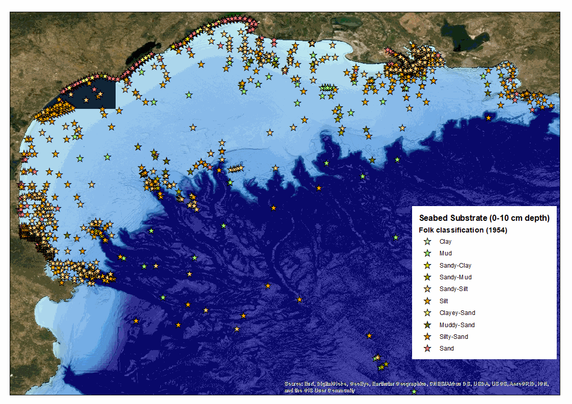
The Gulf of Lion is located in the north-western part of the western Mediterranean basin, between Cap Creus (Pyrenean chain) in the south-west (Spanish border) and Cap Sicié (near Toulon) in the north-east. It is characterised by a wide crescent-shaped continental shelf, 200 km long. The continental shelf reaches a maximum width of 70 km off Cap d'Agde and narrows towards the east and west as it approaches the Provencal and Pyrenean-Catalan margins. It extends between 0 and 120 to 180 m deep and has an average inclination of 0.5° (reaching up to 5° at the deltaic slopes). Numerous canyons notch the edge of the platform. The river Rhône is the main source of terrigenous inflows from the Gulf of Lion, up to about 90% (Bourrin et al., 2006), and the Rhône prodelta is an area of significant accumulation of fluvial solid inflows. The current morphology of the Gulf of Lion is strongly linked to current river flows, but also to the legacy of past environmental conditions from the last low sea level 20,000 years ago. In 2012, Ifremer had planned to produce a map of the seabed substrate in this sector based on a compilation of acoustic and sedimentary data. Indeed, the Gulf of Lion has been the subject of oceanographic studies and campaigns for many years. An inventory of the campaigns at sea had been carried out thanks to the SISMER (Scientific Information Systems for the Sea) community databases and Infoterre internet portal managed by the BRGM (the French Geological Survey). These databases had enabled the referencing of laboratories involved campaigns and samples collection in the Gulf of Lion since 1991: - Ifremer, - Shom - University of Perpignan Via Domitia (Cefrem), - Aix-Marseille University (CEREGE ; MIO Mediterranean Institute of Oceanology), - CNRS (French National Centre for Scientific Research) - Sorbonne University, - IRSN (Institute for Radiological Protection and Nuclear Safety), - the French Office for Biodiversity (OFB) (previously Marine Protected Areas Agency), - the Conseil départmental de l’Hérault in the framework of the European projects Beachmed, - the Rhone-Mediterranean-Corsica Water Agency. Partnership agreements for the provision of samples and data had been signed with these research laboratories or local authorities. If the production of a map had not been successful, a total of 2 110 samples (see xls-sheet1 file) had been recorded in the Gulf of Lion. The sampling tools used were diverse and the techniques used to analyse the samples also varied from one campaign to another. To validate the results of existing analyses, we compared the samples preparation and analysis protocols. When we had no information on these protocols, the granulometric analysis was redone when the sample still existed, or the result was compared with the valid analysis of a geographically close sample. In the absence of these information, the analyses were rejected. The analyses provided by IRSN (150 samples) and CEREGE (321 samples) were acquired using a sample preparation and analysis protocol similar to that adopted for our study and were validated. Out of 144 samples taken by Ifremer, the analyses were redone in order to obtain homogeneity with the sample preparation and analysis protocol of CEREGE and IRSN. Data from the University of Perpignan, resulting from the work of Jean-Claude Aloisi (between 1970 and 1986) which led to the first sediment distribution map of the Gulf of Lion dating from 1986, were analysed by sieving at 40 µm, determining the pelite/ sand limit at this size. Other classifications (Folk, ISO 13 320, Uden and Wentworth, ...) determine a pelite/sand limit at 63µm. It is therefore difficult to compare these data without recalibrating all the data of the 40µm laser granulometers. In the end, in order to guarantee an intercomparison of the analyses, only 1659 samples were validated after harmonisation and standardisation and all the data from the so-called "Aloisi" campaign had to be discarded (see xls-sheet2 file). The composition of the surficial sedimentary cover (of 10 cm thick; which corresponds to the capacity of penetration into the sediments of the acoustic waves emitted by the multibeam echosounders) of the Gulf of Lion shelf is relatively heterogeneous. It is strongly linked to current river inputs, but also to inherited environmental conditions from the last low sea level 20,000 years ago. At present, coarse river inflows feed the sandy coastline near the mouths, while fine inflows are transported by currents and waves over the entire platform. Different sedimentary facies appear from the coast towards the slope, parallel to the shoreline: - The inner shelf is subject to the action of swell and storms (Guizien, 2009) that cause sediment to resuspend. Richly sandy outside of the areas influenced by rivers, this area is relatively poor in clay (from 2 to 16%); clay deposits cannot be made under these conditions. It runs along the coastline, up to 30 m. It gets thinner, until it disappears, opposite the mouth of the Rhône (Gulf of Fos) in its eastern part, and opposite Cap Creus in its western part. - The median shelf, richer in clay (from 16 to 26%) located between 30 and 100 m depth on average, is known as the "median mudflat". The slope break, observed between 40 and 50 m, corresponds to the transition zone between the silto-pelitic deposits and the offshore sediments (clay phase). The particle diameter gradient is quite marked, depending on the bathymetry: 50 to 80 µm between 30 and 50 m and 10 to 15 µm from the 50 m isobath. This tendency is rather marked near the mouths of rivers, particularly the Petit Rhône, the Orb and the Hérault. - The outer shelf (located at the limit between the continental shelf and the slope) presents a sandy to sandy-muddy mixture (60% sand with a median diameter of between 80 and 100 µm and up to 500 µm). These so-called "relict" sands are derived from coastal deposits dated of Ante-Holocene age, when the continental shelf was nearly emerging. At the mouth of the Grand Rhône, the most important source of particles in the Gulf of Lion, the internal plateau does not have the same appearance, as it is the site of significant sedimentation concentrated in the form of a prodelta. At the level of this prodelta, the distribution of sediments shows a significant granulometric gradient near the mouth, with a concentration of coarse sands (>450µm) at the top (mouth bar), followed by a rapid predominance of fine sediments from the 20 m isobath, which in the area corresponds to the depth of closure of the swells. The predominance of the fine fraction occurs much faster than on the rest of the plateau. The average slope of the prodeltaic zone has been evaluated at 5° and the 100 m isobath is about ten kilometres from the mouth of the Rhône, compared with more than 50 km for most of the French Mediterranean coast of the Gulf of Lion. The Rhone's fluvial inflows are also subject to a transport dynamic towards the west and south-west, which leads to a circulation of particles over the entire continental shelf of the Gulf of Lion and their potential transport to deeper area through the heads of submarine canyons (Durrieu de Madron et al., 1990). The hydro-sedimentary functioning of the Gulf of Lion is thus characterised as follows: (i) a forced sedimentation of fine particles in the prodeltas, (ii) an advective transfer of the fine mineral from the continental sources and prodeltas to the sediments of the circalittoral mudflat, and (iii) the export of homogeneous material from the continental shelf, through the outfalls of the south-western shelf. Within this particulate dynamics, the prodelta plays an important role. By its characteristics as an area of decantation and regulation of continent/sea exchanges, the prodelta is apparented to the estuarine turbidity maximum of the macrotidal seas. Finally, as the surface sediments analysed in the Gulf of Lion are mainly composed of fine sediments, the authors believe that the simplified Flemming classification best suited to this type of environment and should be preferred for mapping the distribution of sedimentary facies in the study area. References : Guizien (2009) - Spatial variability of wave conditions in the Gulf of Lions (NW Mediterranean sea). Life and Env. 59 (3-4):1-10. Durrieu de Madron et al. (1990) - Hydrographic structure and nepheloid spatial distribution in the Gulf of Lions continental margin.Continental Shelf Research 10(9-11):915-929. DOI: 10.1016/0278-4343(90)90067-V
-
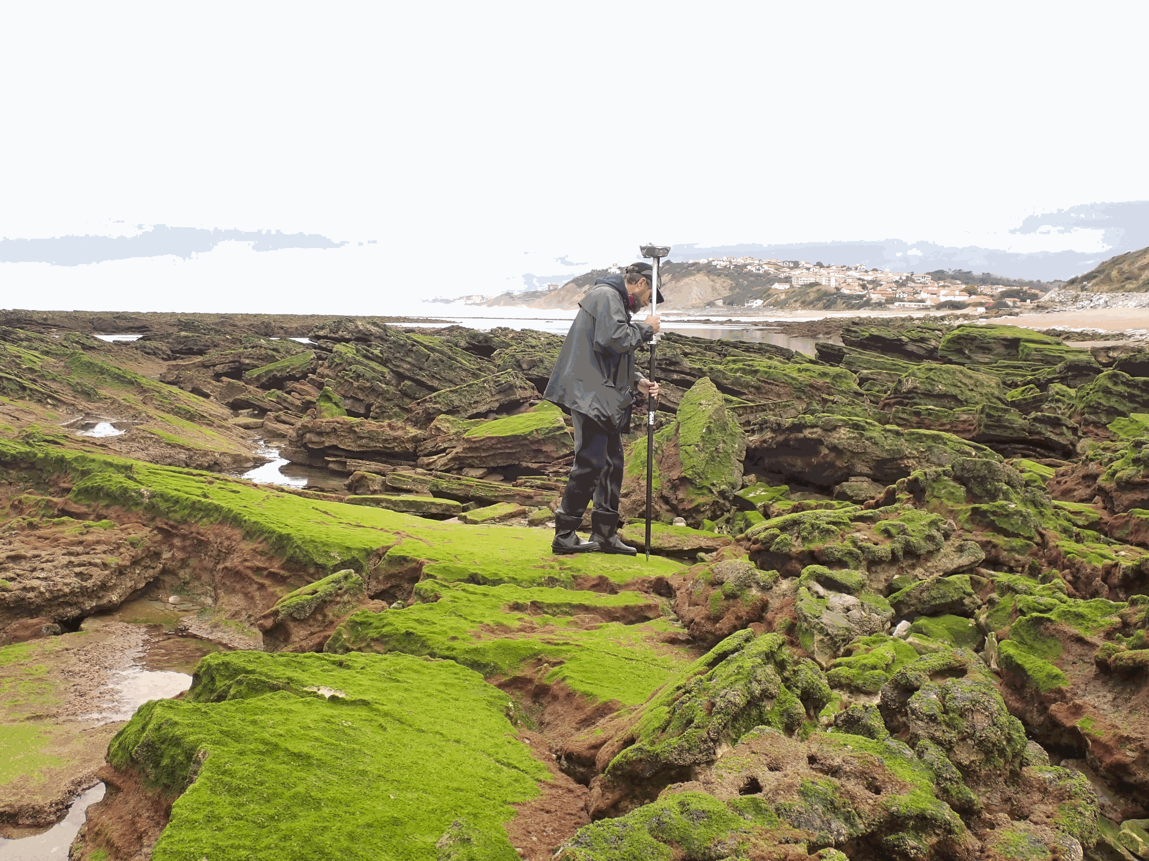
The present dataset is based on a nine site study of fine seabed topography in intertidal zones. Four coral sites (Maupiti A, B and C and Niau islands) and five rocky sites (Ars en Ré, Socoa, Parlementia A and B and Banneg island) have been explored. The data has been gathered using on-foot GNSS RTK for all sites (Trimble R8/R8S and Leica sytems) except Banneg island, where aerial Lidar data from Litto3D program has been used. The horizontal resolution varies between 3.8 and 12cm allowing to describe a wide range of spatial scales (generally over 3 spectral decades). The data has been processed to explore the statistical and spectral metrics which can be used to characterize the architectural complexity of seabeds.
-
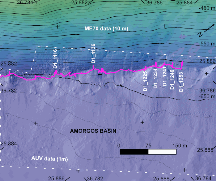
The AMORGOS-23 cruise (https://doi.org/10.17600/18003211) was conducted onboard R/V Europe from April 26th 2023 to May 9th 2023. Using HROV Ariane equipped with 4K cameras, we surveyed the main active faults between Amorgos and Anafi islands in order to identify and quantify recent deformation of the seafloor linked to the 1956 Amorgos earthquake. During dive 244-1, we surveyed the steepest scarp of the Amorgos fault, along its central segment. We provide here seven scaled Digital Outcrop Models (in .obj format) calculated from the HROV videos with MATISSE 3D software. There location (model origin) is also provided in a table, together with information about the portions of the videos used to produce the models. Due to incomplete navigation data, the models are not properly oriented.
-
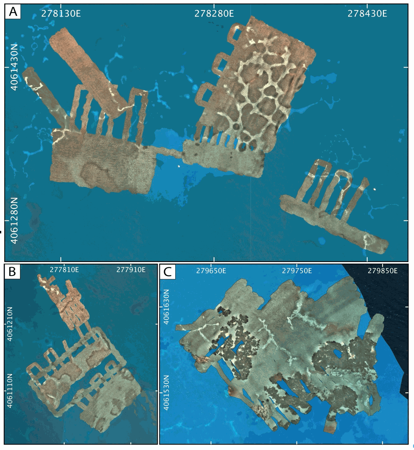
AUV photomosaics of the seafloor at the shallow-water Milos hydrothermal system. Photomosaics were acquired with the Sparus II (Iqua, Girona) AUV and constructed from vertically acquired still images. Images were acquired in July 2019 at the Paleochori and Spathi Bays. Photomosaics are provided as geotiffs (UTM Zone 35). This dataset includes both original photomosaics, that show distortions due to AUV navigation drift, and georeferenced photomosaics, that have been registered with the associated drone photomosaics at these same areas.
-
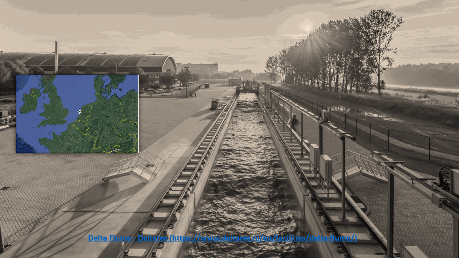
Multifrequency single- and multibeam echosounders are mature technologies for underwater mapping. However, the current scarcity of sediment reference datasets of both bottom backscatter angular response and water column scattering, hampers the generation of applicable information. Reference data derived from measurements in a controlled environment should optimize the use of empirical backscatter data for underwater observation and management. In order to prepare for such comprehensive and ground-breaking experiments, we conducted a feasibility experiment in the Delta Flume, Deltares, Netherlands. Multi-frequency single- and multibeam echosounder data of the flume floor and of fine-grained, in-water sand plumes were recorded. The results revealed that flume reverberation did not interfere significantly with bottom targets and that fine-sand plumes in the water column were clearly detected. Future comprehensive experiments will feature multi-frequency multi-angle measurements on a variety of sediment types, shell densities, interface roughnessess, and plumes of various sediment grain sizes, shapes and concentrations.