 Metadata catalogue
TEXTE
Type of resources
Available actions
Topics
Keywords
Contact for the resource
Provided by
Years
Formats
-
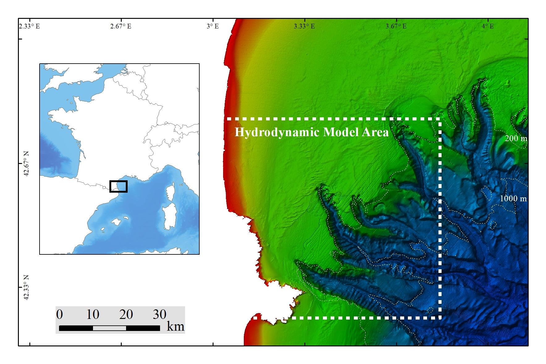
Extreme percentiles (1%, 5%, 95%, 99%) of bottom temperature and salinity, as well as (95%, 99%) of bottom currents, were modeled using SYMPHONIE on a numerical domain covering 65 × 60 km at a resolution of 80 m. The 10-m bathymetry used inside the Lacaze-Duthiers Canyon was collected during the CALADU_2021 cruise (https://doi.org/10.17600/18001575). Statistics of extreme values were derived from hourly fields simulated between November 1, 2012, and April 15, 2014. This period includes two contrasting winters: the winter of 2012–2013, which was cold with dense water cascading, and the winter of 2013–2014, which was warm. This dataset was produced to assess the probable distribution of habitats (habitat suitability modeling) for cold-water corals in the Lacaze-Duthiers Canyon at different resolutions as part of the European H2020 project REDRESS (Restoration of Deep-Sea Habitats to Rebuild European Seas, https://redress-project.eu/, Grant Agreement No. 101135492). SYMPHONIE is a component of the national service SIROCCO (research infrastructure ILICO). This dataset is related to the article "Mapping and Conservation of Cold-Water Corals in the Lacaze-Duthiers Canyon for Transboundary Management", submitted to Mediterranean Marine Science by Fabri et al. in 2025.
-
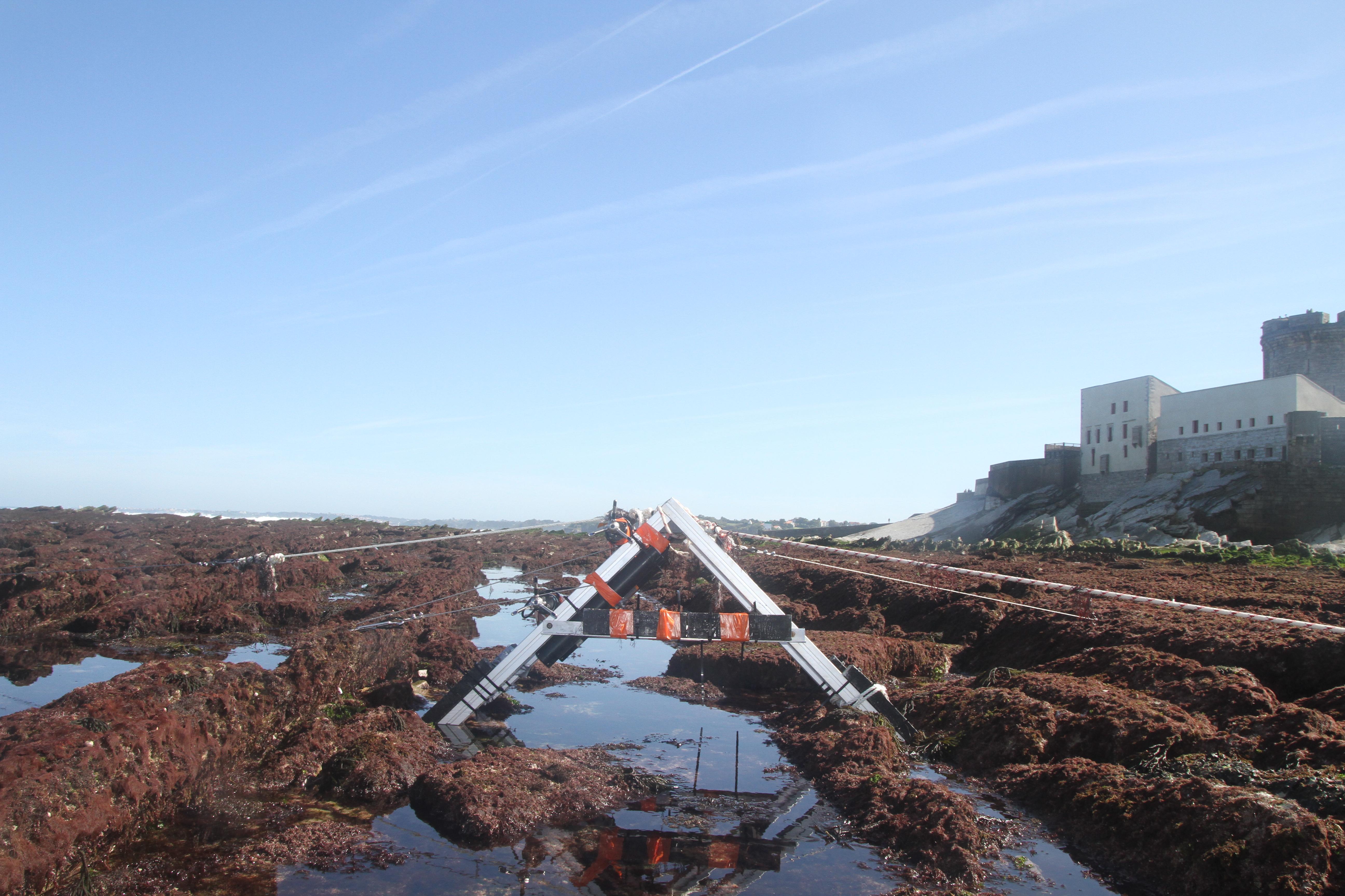
The database displays the field measurements recover during a one-week experiment in October 2021 on the Socoa's rocky platform, France. The general objective of the study was to evaluate the momentum balance over the rocky platform, in particular to quantifiy the combined effect of high seabed roughness and waves on the coupling between circulation, wave force and mean water level. The analysis is performed along a single cross-shore transect. The data include: - the cross-shore bathymetric profile - the time-series of integrated wave parameters, local mean water depth and wave-averaged currents over successive 30-min bursts - the depth- and wave-averaged momentum fluxes following the formulation proposed by Smith 2006 and Bruneau et al. 2011. The fluxes are median values obtained over significant wave height to depth ratio bins
-
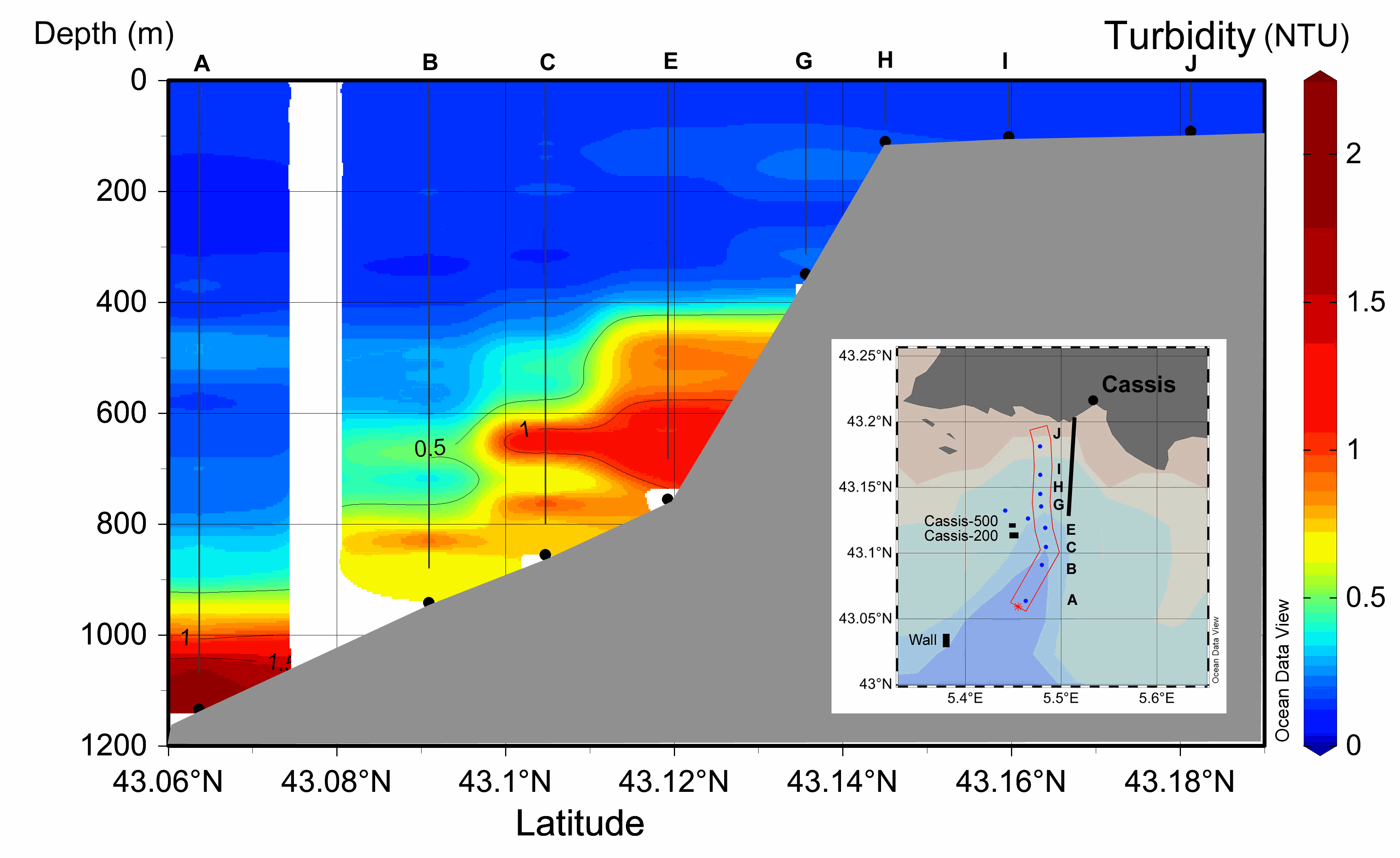
M&M - Turbidity and Suspended Sediment Concentration (SSC) An autonomous optical backscatter sensor (NKE STBD 1200) was installed on the CTD probe in 2014 during the BATHYCOR1 cruise in order to collect ten vertical turbidity profiles along the canyon axis (23th August 2014) (Fig. 1, Table 2). The profiles had to be interrupted at an average altitude of 40 to 70 mab (m above the bottom) for safety issues. The sensor was previously calibrated with Formazin as recommended by NKE marine electronics (www.nke-marine-electronics.com). The results are given in Nephelometric Turbidity Units (NTU). In order to link the NTU values to the Suspended Sediment Concentration we built a calibration curve of our sensor using bottom sediment that had been previously sampled with a push core (CT9) during ROV dive 407-11, cruise ESSROV2010 (Fontanier et al., 2012). Particle grain sizes were analyzed using laser diffraction and median grain size (D50) was 11 µm, although some particles were as large as 150 µm (see (Fontanier et al., 2012) - figure 2D). We first measured the turbidity in a 10-liter container of distilled water in which we added NaCl to obtain a salinity concentration of 38.4 g/l. We checked the concordance with a laboratory turbidimeter (Hatch 2100n IS - Iso Method 7027) to confirm the starting point (0.04 NTU). Then we progressively added a known quantity of particles in the container of salty distilled water. After each addition of particles, the water was mixed and left for 30 seconds before recording the turbidity every second for 5 minutes. We tried to keep a uniformly mixed suspension with no sediment settling but failed to prevent large particles from sinking to the bottom of the container. We then calculated the mean of the recorded turbidity in NTU for each known concentration of particles. This allowed building a calibration curve, starting from 0.04 NTU to 3 NTU, which corresponded to the range of our in situ values (online supp. mat. Fig. A1). Results - Turbidity and Suspended Sediment Concentration (SSC) The ten vertical turbidity profiles (NKE STBD 1200) collected at the CTD stations in the canyon axis show turbidity values ranging from 0.15 NTU on the shelf and in the surface layer to 2.2 NTU at the bottom of the canyon exit ; Turbidity values were very low above 300 m depth (<0.2 NTU) on the whole set of profiles (on the shelf, flanks and canyon axis) while the stations located downstream of the bauxite residue effluent in the canyon axis (Stations A, B, C, D, E) displayed maximum turbidity in the lower layer. Maximum turbidity values were measured above the bottom at the deepest station (A), exceeding 2 NTU at the canyon exit. However, the maximum particle load does not always lie just above the bottom: at stations B and C there was an intermediate maximum between 600 and 700 m, and to a lesser extent at ~500 m at station A. The turbid layer was thicker closer to the pipeline effluent. As the effluent is a mixture of particles of different sizes in freshwater, it is expected that downstream it generates several layers according to water density and particle size. The east-west orientation of the bathymetry around stations C, E, G might also contribute to the dispersion of the particles (cross-axis current), as shown by the multi-layered turbidity profile at station K (bottom depth 770 m; not shown). Thus the coral colonies at Cassis-500 are impacted by the turbidity of the red mud. According to the calibration of our sensor, we roughly correlated a turbidity value of 1 NTU to an SSC=0.6 mg/l, and the maximum measurement of around 2.5 NTU to an SSC=2 mg/l.
-
GraviMob-1 campaign is an underwater gravimetric survey conducted near the southern coast of France in the Mediterranean Sea in March 2016. The AUV Asterx was used to carry the GraviMob system. The operation was performed on board the vessel Europe. The data and processing results of this campaign are supporting the paper "High-resolution gravity measurement on board an Autonomous Underwater Vehicle: Data reduction and accuracy assessment". The dataset thus contains the following elements: 1. The raw data exported from GraviMob 2. The shipborne gravity data provided by SHOM 3. The processing results
-
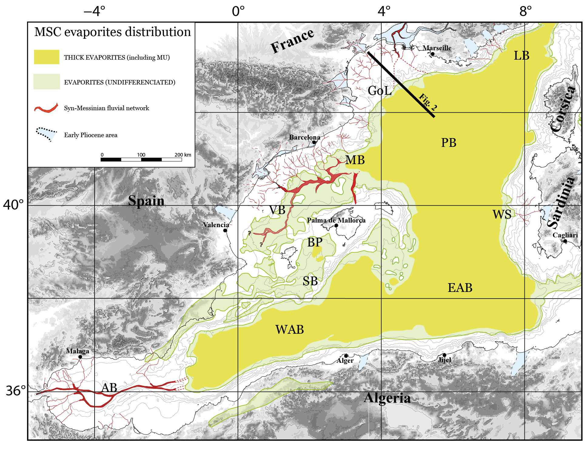
The Western Mediterranean Sea is a natural laboratory to address questions about the formation and evolution of continental margins and the relationship between surface and deep processes. The evaporites deposited during the late Miocene’s Messinian Salinity Crisis (MSC) strongly impact its sedimentological and geomorphological evolution. Hereafter, we present a compilation of some of the main regional seismic stratigraphic markers throughout the Western Mediterranean Sea. We provide in xyz format (z in second twt) the original, not interpolated, points interpretation of the following horizons: i) Acoustic basement, ii) Base and Top of the MSC salt, also known as Mobile Unit (MU), iii) base Pliocene and iv) Seafloor. The available reflection seismic dataset, coming from a collaboration between French, Spanish, Algerian and Italian research institutes, covers most of the Western Mediterranean sub-basins with the exception of the Ligurian Basin. This compilation is currently the most comprehensive and updated available in literature and provides a useful contribution to the scientific community working in sedimentary, tectonics and geodynamics studies in the Western Mediterranean Sea.
-
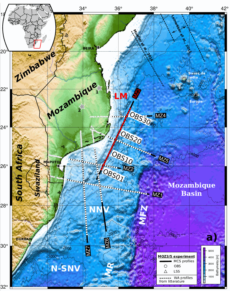
Coincident wide-angle and multi-channel seismic data acquired within the scope of the PAMELA Moz3-5 project allow to reconsider the formation mechanism of East-African margins offshore southern Mozambique. This study most specifically focuses on the sedimentary and deep crustal architecture of the Limpopo margin (LM) that fringes the eastern edge of the Mozambique’s Coastal Plain (MCP) and its offshore southern prolongation the North Natal Valley (NNV). It relies primarily on the MZ3 profile that runs obliquely from the northeastern NNV towards the Mozambique basin (MB) with additional inputs from a tectono-stratigraphy analysis of industrial onshore-offshore seismic lines and nearby or crossing velocity models from companion studies. Over its entire N-S extension the LM appears segmented in (1) a western domain that shows the progressive eastward crustal thinning and termination of the MCP/NNV continental crust and its overlying pre-Neocomien volcano-sedimentary basement; and (2) a central corridor of anomalous crust bounded to the east by the Mozambique fracture zone (MFZ) and the oceanic crust of the MB. A prominent basement high marks the boundary between these two domains. Its development was most probably controlled by a steep and deeply rooted fault, i.e. the Limpopo fault. We infer that strike-slip or slightly trans-tensional rifting occurred along the LM and was accommodated along this Limpopo fault. At depth we propose that ductile shearing was responsible for the thinning of the continental crust and an oceanward flow of lower crustal material. This process was accompanied by intense magmatism that extruded to form the volcanic basement and gave to the corridor its peculiar structure and mixed nature. The whole region remained at a relative high level during the rifting period and a shallow marine environment dominated the pre-Neocomien period during the early phase of continent-ocean interaction. It is only some times after break-up in the MB and the initiation of the MFZ that decoupling occurred between the MCP/NNV and the corridor allowing for the latter to subside and being covered by deep marine sediments. A scenario for the early evolution and formation of the LM is proposed taking into account both recent kinematic and geological constraints. It implies that no or little changes in extensional direction occurred between the intra-continental rifting and subsequent phase of continent-ocean interaction.
-
Maupiti ("the Stuck Twins'') is a diamond-shaped island located in the western part of the Society archipelago in French Polynesia. The present study focuses on the data recovered over a single cross-barrier transect located in the south-west barrier during the MAUPITI HOE field campaign, from 5 to 18 July 2018. The studied area is representative of the reef structure observed along the 4km-long southwestern barrier reef, showing an alongshore-uniform structure exposed to swell approaching with weak incident angles, a healthy reef colony. In the cross-barrier direction, the reef displays a clear partitioning of bottom roughness that ranges from low-crested compact structures at the reef crest to higher and sparser coral bommies on the backreef. The experimental setup was specifically designed to analyse and differentiate the dynamics over three roughness-contrasting sections found over the barrier reef.
-
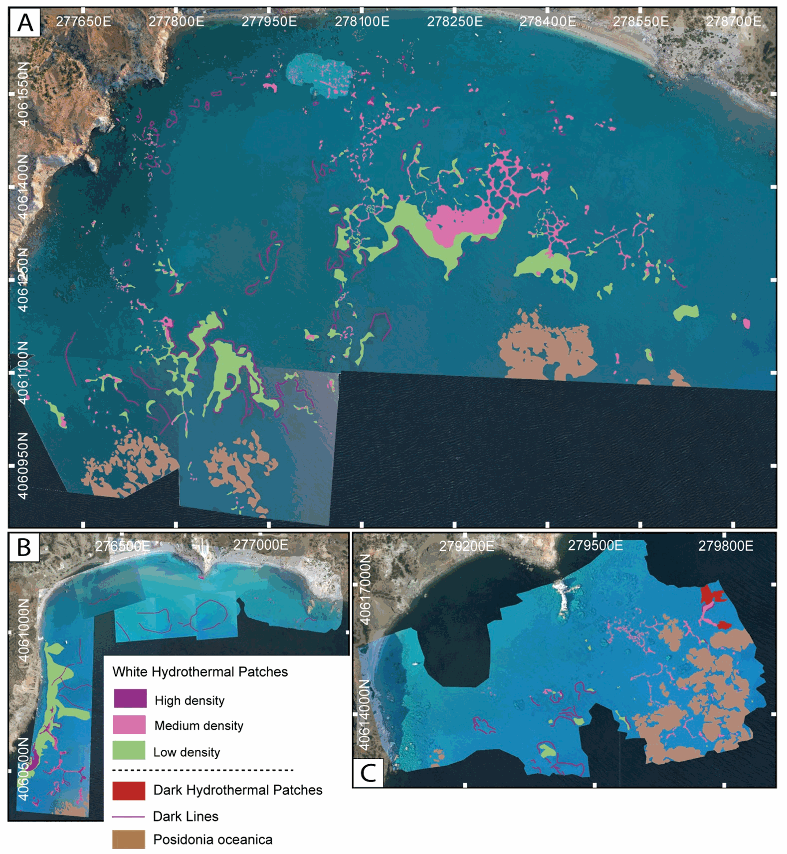
This dataset inscludes shapefiles interpreted from photomosaics over the Milos shallow water hydrothermal system, and instrument locaitons, from fieldwork in July and September 2019. The shapefiles are organized by study areas (Agia Kyria, Paleochori, and Spathi bays). Details are provided in the associated paper (Puzenat et al., 2021) in addition to information in the Readme File associated. a) Shapefiles of seafloor textures interpreted from drone imagery. b) Shapefiles of seafloor texttures interpreted from AUV imagery. c) Shapefiles of instruments deployed in the study area in September 2019.
-
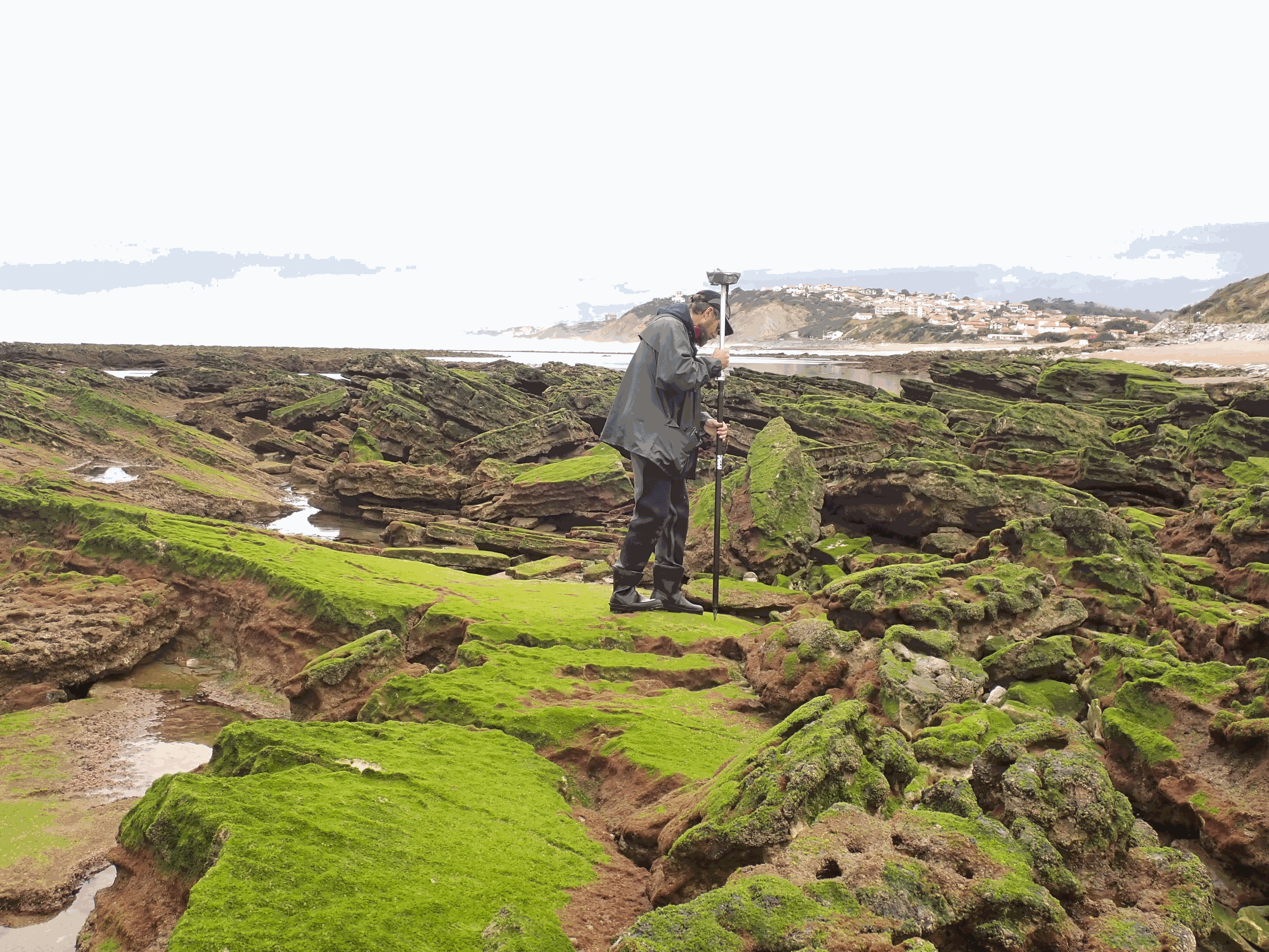
The present dataset is based on a nine site study of fine seabed topography in intertidal zones. Four coral sites (Maupiti A, B and C and Niau islands) and five rocky sites (Ars en Ré, Socoa, Parlementia A and B and Banneg island) have been explored. The data has been gathered using on-foot GNSS RTK for all sites (Trimble R8/R8S and Leica sytems) except Banneg island, where aerial Lidar data from Litto3D program has been used. The horizontal resolution varies between 3.8 and 12cm allowing to describe a wide range of spatial scales (generally over 3 spectral decades). The data has been processed to explore the statistical and spectral metrics which can be used to characterize the architectural complexity of seabeds.
-
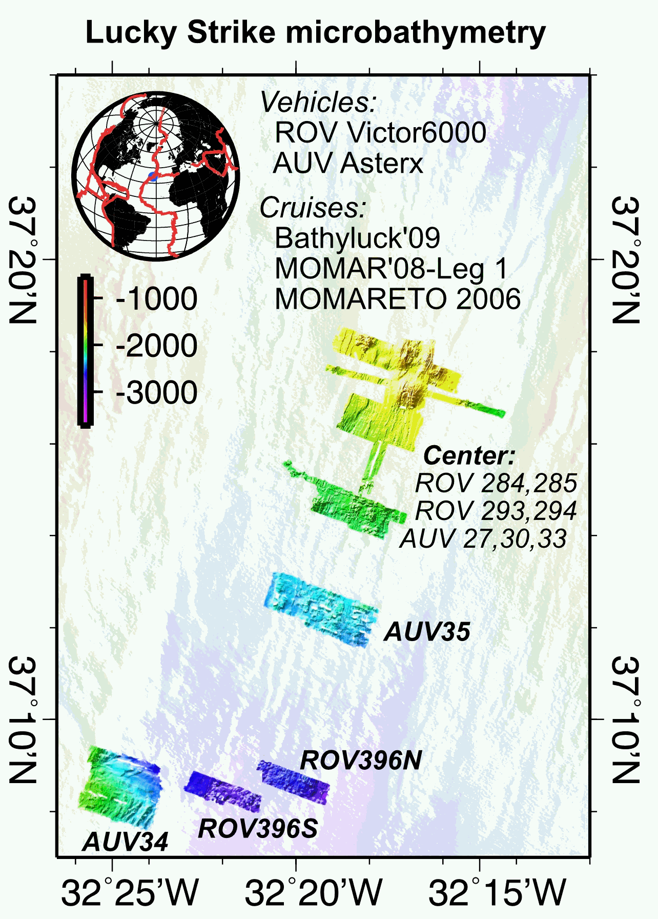
Multibeam near-bottom bathymetry from the Lucky Strike ridge segment along the Mid-Atlantic Ridge. The bathymetry data were acquired during AUV Asterx and ROV Victor6000 surveys during three different cruises (MOMARETO 2006, MOMAR'08-Leg1, & BATHYLUCK'09). The dataset includes a central grid (LuckyStrike_microbathymetry_Centre) that combines data from several AUV and ROV dives, and where original bathymetry grids for each dive have been manually shifted and combined into a single grid, using other datasets (shipboard bathymetry, acoustic sonar data from the Lustre'96 data) for geographical reference. The rest of the grids are from individual ROV or AUV dives. All grids are provided in NETCDF GMT .grd format, and with two associated GEOTIFFS with both the bathymetry DEM and the hillside (illumination) file. All grids are given in WGS84 (WGS 84 - WGS84 - EPSG:4326).