 Metadata catalogue
SEGY
Type of resources
Available actions
Topics
Keywords
Contact for the resource
Provided by
Years
Formats
Representation types
Update frequencies
Scale
-

This seismic data set was recorded in September 2015 on board the R/V Pourquoi Pas? during the GHASS cruise (IFREMER) on the western Black Sea, offshore Romania. The available profiles (part of the collected data) within this deposit are located on the continental slope, bathymetry between 500 to 1200 meters. The pre-processing of the seismic data included common midpoint binning @6.25 meters, trace and shot edition, source delay correction, and a 35-375 Hz band pass filtering. Detailed Root Mean Square Velocity analyses were performed on semblance panels computed using super gathers every 150 m. Normal Move Out time correction was then applied on the Common Mid Point (CMP) using these velocities prior to stack. Interval velocities were computed using the Dix equation. The velocity model was then interpolated every CMP location, converted to depth and smoothed to perform post-stack depth migration. The depth migrated sections and the depth velocity models have been output to standard SEG-Y rev1 format (https://library.seg.org/pb-assets/technical-standards/seg_y_rev1-1686080991247.pdf) with values written using “big-endian” byte ordering and IEEE floating-point. For a given profile, both SEGY files have the same number of traces and the same bin locations. Velocity unit is in meter.second-1. The depth sampling is set to 0.5 meter for both files. The recording delay is zero for the depth migration SEGY files. The delay is coded in meters and constant for a given depth velocity SEGY file, stored within the Trace Header (bytes 109-110). Trace coordinates are also stored within the Trace Header using WGS84 +DDDMMSS.ss format with a scale factor of -100 (bytes 81-88, which means that the value has to divided by 100) . For more convenient access to the location of the profiles, these coordinates are also stored into ASCII files using decimal degrees.
-
The ASTARTE 2014 seismic campaign aims extending the area of previous seismic surveys to a distance of around 20 nautical miles from the coast till the edge of the continental shelf. The survey plan was made for acquisition of 24 profiles divided in two classes: the in-line class perpendicular to the coastline and the cross-line class orthogonal to the in-line lines. The main reason for selecting the offshore Quarteira region is because this region is a target for tsunami in prints on the continental shelf although the entire Algarve coast can be a repository of past tsunami geologic records.
-

The TOPOMED-FREEZE campaign was organized as a joint campaign of the TOPOMED and FREEZE projects sponsored by the Fundação para a Ciência e a Tecnologia (FCT) (Plate reorganization in the western Mediterranean: lithospheric causes and topographic consequences, TOPOEUROPE/0001/2007; Submarine FREshwater dischargEs: characteriZation and Evaluation study on their impact on the Algarve coastal ecosystems, PTDC/MAR/102030/2008). These two projects share complementary study areas and objectives. The first concentrates on the effects of neotectonics on the evolution of landscape and environments and the second on the investigation of Submarine Fresh-Water Discharges.
-
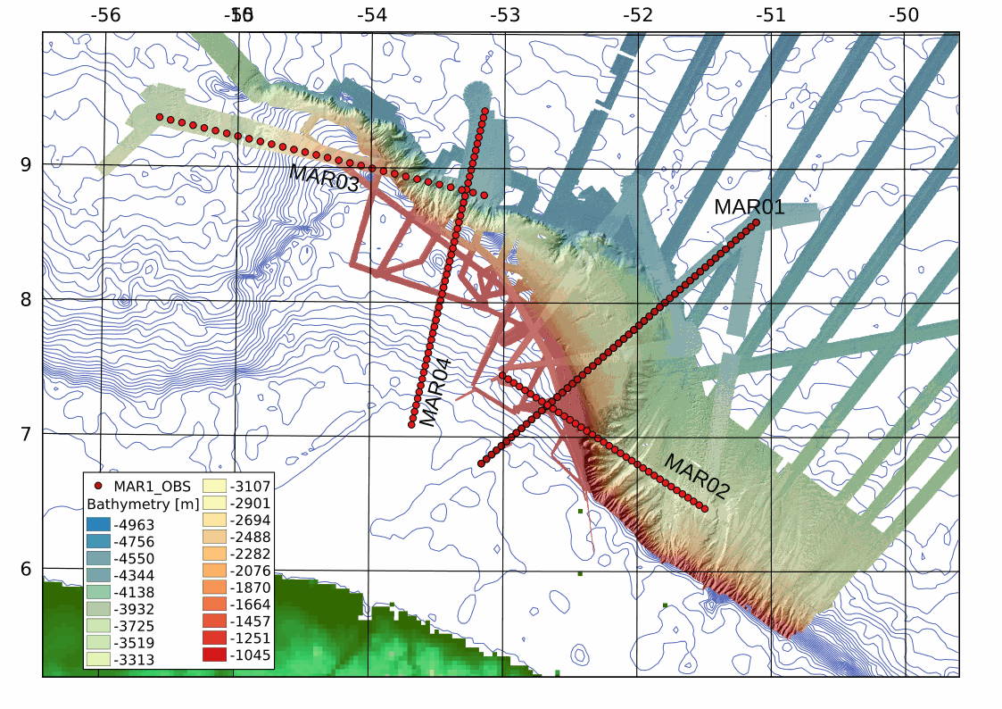
This archive includes wide-angle seismic data from profiles 1, 2, 3 and 2 of the MARGATS cruise offshore French Guyana and Surinam including navigation files. The objective is more precisely to characterize the crustal structure and evolution of marginal plateaux, sub-marine reliefs that are associated to 30 % of the transform margins in the world. These reliefs are systematically observed at the junction of different ages in relay zones between divergent and transform segments. Their building remains enigmatic although they represent reliefs established in geodynamical nubs that are keys ton understand the localisation of transform margins. This project MARGATS intend to image the deep structure of the marginal plateau (wide angle seismic and multichannel seismic MCS). The experimental site proposed is the Demerara plateau offshore French Guyana and Surinam and located at the junction between Central Atlantic locally opened in a divergent mode and Equatorial Atlantic opened mainly in transform mode in the area. Hence, this plateau has recorded at its different borders the divergent opening of the central Atlantic and the tranform opening of the Equatorial Atlantic. It may be this situation itself that leads to the formation of the plateau, but it requires to precisely constraint its deep internal structure. Finally the Demerara plateau is one of the more studied with petroleum seismic data and high resolution seismic data. It is then one of the ideal place to conduct a high resolution wide-angle deep seismic survey.
-
This project aims to characterize the evolution of the coastline during the Quaternary and discern what were the contributions to this evolution: 1) neotectonic, 2) eustatic variations and 3) sedimentary transport; for this purpose was selected as study area the coastal stretch between Cabo da Roca (~ 38 46'N) and the village of Comporta (~ 38 20'N).
-
The ERSTA project intended to study the seismogenic and tsunamigenic bodies and prepare an sismotectonic model for the Algarve region. For this project, in this campaign, was intend to carry out a geophysical survey that will contribute to a more detailed characterization, in the offshore region, of São Marcos-Quarteira and Carcavai faults. The SANDEX project aims to evaluate the physical impact from the extraction of sand and gravel in the coastal sediment balance and evolution of the coastline. The campaign aims to collect bathymetric data that will contribute to monitoring of the impact caused by the exploitation of sand deposits carried off the Quarteira as well as for the assessment of sediment budget of the study area.
-
The FREEZE 2010 geophysical cruise was planned to acquire a detailed bathymetry just off Olhos d'Agua, high resolution seismic and Side Scan Sonar data in order to investigate and define the geological and the tectonic settings off Olhos d'Agua (Algarve coast, South Portugal) and to find any possible evidence of supposed existing submarine groundwater discharges (SGDs) in this area.
-
The Tagusdelta campaign had technical and scientific objectives. The main technical objective was to make the proof of concept of the new proposed method for the acquisition of 3D very high resolution seismic reflection data. The accomplishment of this objective included: deployment and data acquisition systems tests; positioning uncertainty assessment; seismic and positioning data processing for the 3D seismic volume generation. From the scientific point of view the main objective was to acquire very high resolution seismic reflection data that allow the characterization of the frontal area of the Tagus ebb-tide delta seismic stratigraphic facies arquitecture. A special focus was placed in the: identification, characterization and mapping of mass wasting features, in order to allow a first trial of the Pleisto-Holocene mapping and chronostratigraphy of these features in the Tagus delta; imaging the morphologies of landslide structures with 3D seismic, particularly in what concerns the landslide already identified with the previous data, to allow the quantification and precise location of the events, to generate data of unprecedented realism that can be fed into the tsunamigenic mathematical models.
-
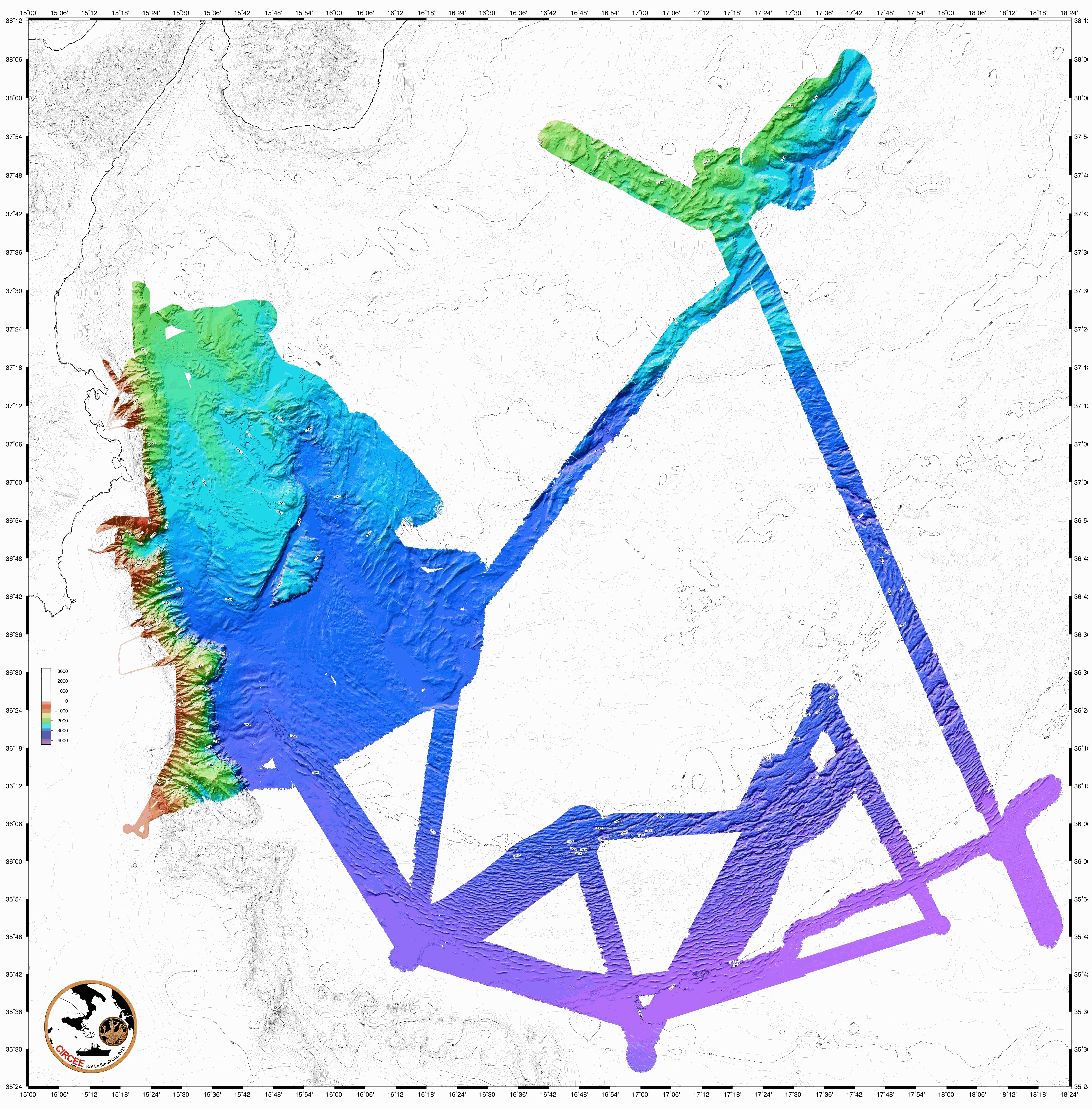
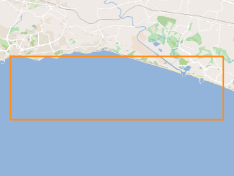
The following data were acquired in 2013 by the french research vessel N/O Suroit during the CIRCEE cruise (see the cruise report): - High-resolution 72-trace seismic data. The files are available in the segy format. A map is provided to locate the 1500 km of seismic profile acquired. - Gridded bathymetry data (resolution : 90m) available in GRD format (software GMT Generic Mapping Software de Wessel & Smith based on NetCDF libraries). A map is available. - Bathymetry data from multibeam echo sounder Kongsberg-Simrad EM302. The data are available in the raw data mbg and include the travel time and amplitude (reflectivity). - Highfrequency chirp-sonar data. The files are available in the segy format. A map is available in the cruise report.