 Metadata catalogue
Raster Dataset
Type of resources
Available actions
Topics
INSPIRE themes
Provided by
Years
Formats
Representation types
Update frequencies
status
Scale
Resolution
-
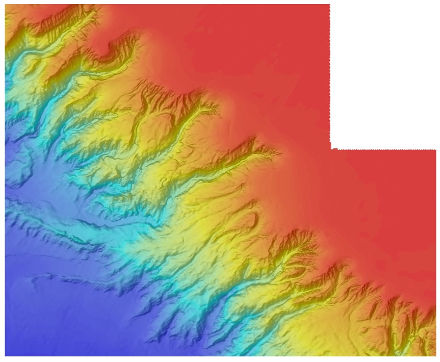
Modelo Digital de Escoamento, criado com base num modelo digital do terreno com pixel de 25X25 metros. Este modelo de escoamento é um produto intermédio do trabalho de GeoCodificação de rios e bacias desenvolvido pelo IST. Serve de base para a geração, entre outros, dos limites das bacias hidrográficas e da rede hidrográfica hidrológicamente correta, que por sua vez serve para a produção das massas de água rios da DQA.
-
Bathymétrie du canyon de Penmarc'h au canyon de Saint-Nazaire, zone BOB2 (synthèse, projet CoralFISH, 2012), au pas de 50 mètres. Traitements réalisés: Les données sont issues de : - BOBGEO1 (2009) : N/O Pourquoi Pas ?,http://dx.doi.org/10.17600/9030060 - BOBGEO2 (2010) : N/O Le Suroît, http://dx.doi.org/10.17600/10020020 - ESSRESON08 (2008) : N/O Pourquoi Pas?, http://dx.doi.org/10.17600/8030070 - ESSNAUT2009(2009) : N/O Pourquoi Pas?, http://dx.doi.org/10.17600/9030020 - VALIDOP (2009) : N/O Atalante, http://dx.doi.org/10.17600/9010030 - ESSINF (2010) : N/O Le Suroit, http://dx.doi.org/10.17600/10020070 - MNTs de la ZEE Atlantique (au pas de 125 m) Traitements réalisés avec le logiciel ISATIS par Laurent de Chambure, Jean-François Bourillet et Benoît Loubrieu.
-
Bathymétrie de la plongée 256-05 de l'AUV (Autonomous Underwater Vehicle) IdefX, au large de Mayotte (campagne MAYOBS4, 2019), au pas de 1 mètre (projection Mercator 13°S). Ce jeu de données est un Modèle Numérique de Terrain bathymétrique, issu de l'acquisition acoustique du sondeur multifaisceau EM2040 de l'AUV IdefX, lors de la campagne MAYOBS4, du 19 juillet au 4 août 2019, sur le N/O Marion Dufresne. Les profondeurs sont rapportées au niveau des plus basses mer astronomiques (PBMA) au point de référence 12°30' S ; 45°39' E. Rapport de traitement : Pierre Delphine (2020). Mission MAYOBS04. Traitement SMF. N/O Marion-Dufresne 19/07/2019 – 31/07/2019. Protocole. DIT.REM/GM/CTDI_20200323-DP01. Description de la campagne : FOUQUET Yves, FEUILLET Nathalie (2019) MAYOBS4 cruise, RV Marion Dufresne, https://doi.org/10.17600/18001238
-
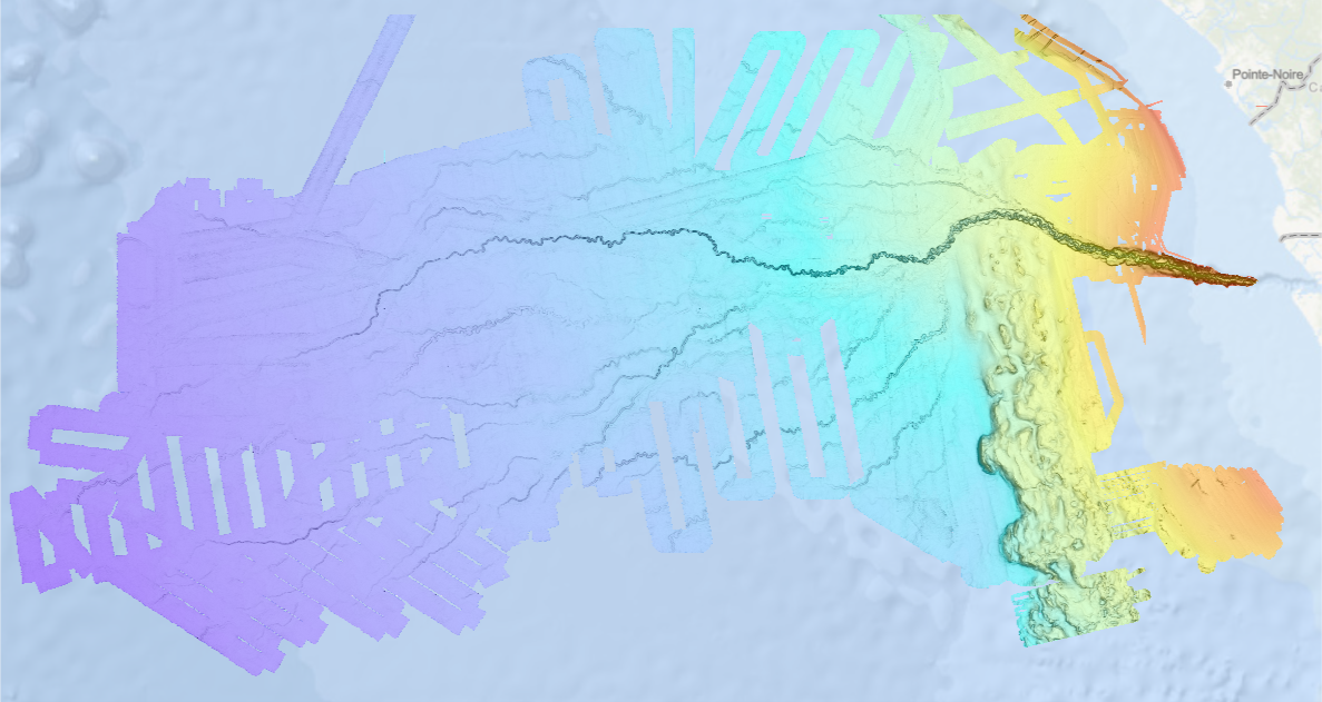
Bathymétrie de l'éventail du Congo, au pas de 100 mètres. Ce Modèle Numérique de Terrain est une compilation de données bathymétriques acquises par sondeur multifaisceau, créée en 2013. Description des campagnes : - VANGRIESHEIM Annick (2005) BIOZRECUP2 cruise, RV Beautemps-Beaupré, https://doi.org/10.17600/5090030 - COCHONAT Pierre, ROBIN Agnès (1992) GUINESS I cruise, RV L'Atalante, https://doi.org/10.17600/92004211 - OPTIC CONGO 2 - MARSSET Tania, DROZ Laurence (2010) REPREZAI_LEG1 cruise, RV Pourquoi pas ?, https://doi.org/10.17600/10030170 - OLU Karine (2011) WACS cruise, RV Pourquoi pas ?, https://doi.org/10.17600/11030010 - SAVOYE Bruno (1998) ZAIANGO1 cruise, RV L'Atalante, https://doi.org/10.17600/98010100 - COCHONAT Pierre (1998) ZAIANGO2 cruise, RV L'Atalante, https://doi.org/10.17600/98010110 - BOURILLET Jean-François (2000) ZAIANGOCAR cruise, RV Le Suroît, https://doi.org/10.17600/20050 - GELI Louis (2000) ZAIANGO-OBS-BIOL cruise, RV Le Suroît, https://doi.org/10.17600/20040
-
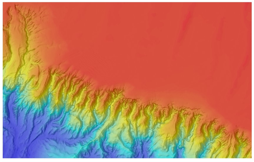
Bathymétrie du canyon de Blackmud au canyon de Douarnenez, zone BOB1 (synthèse, projet CoralFISH), au pas de 50 mètres. Cette résolution spatiale de la grille, à 50 mètres, a été réalisée dans le cadre du projet CoralFISH pour l'édition des cartes "Sur les traces des coraux d'eau froide du golfe de Gascogne, 8 Cartes bathymétriques et géomorphologiques". Les données sont issues des campagnes: - BOBGEO1 (2009) : N/O Pourquoi Pas ? https://doi.org/10.17600/9030060 - BOBGEO2 (2010) : N/O Le Suroît http://dx.doi.org/10.17600/10020020 - ESSRESON08 (2008) : N/O Pourquoi Pas? https://doi.org/10.17600/8030070 - ESSNAUT2009(2009) : N/O Pourquoi Pas? https://doi.org/10.17600/9030020 - VALIDOP (2009) : N/O Atalante http://dx.doi.org/10.17600/9010030 - ESSINF (2010) : N/O Le Suroit http://dx.doi.org/10.17600/10020070 - MNTs de la ZEE Atlantique (au pas de 125 m)
-

Bathymétrie du canyon des Sables d’Olonne au canyon d’Ars, zone BOB3 (synthèse, projet CoralFISH, 2012), au pas de 50 mètres. Les données sont issues des campagnes: - BOBGEO1 (2009) : N/O Pourquoi Pas ?, http://dx.doi.org/10.17600/9030060 - BOBGEO2 (2010) : N/O Le Suroît, http://dx.doi.org/10.17600/10020020 - ESSRESON08 (2008) : N/O Pourquoi Pas?, http://dx.doi.org/10.17600/8030070 - ESSNAUT2009(2009) : N/O Pourquoi Pas?, http://dx.doi.org/10.17600/9030020 - VALIDOP (2009) : N/O Atalante, http://dx.doi.org/10.17600/9010030 - ESSINF (2010) : N/O Le Suroit, http://dx.doi.org/10.17600/10020070 - MNTs de la ZEE Atlantique (au pas de 125 m) Traitements réalisés avec le logiciel ISATIS par Laurent de Chambure, Jean-François Bourillet et Benoît Loubrieu.
-

Bathymétrie du canyon de Cap-Ferret au canyon d’Arcachon, zone BOB4 (synthèse, projet CoralFISH, 2012), au pas de 50 mètres. Les données sont issues de : - BOBGEO1 (2009) : N/O Pourquoi Pas ?,http://dx.doi.org/10.17600/9030060 - BOBGEO2 (2010) : N/O Le Suroît, http://dx.doi.org/10.17600/10020020 - ESSRESON08 (2008) : N/O Pourquoi Pas?, http://dx.doi.org/10.17600/8030070 - ESSNAUT2009(2009) : N/O Pourquoi Pas?, http://dx.doi.org/10.17600/9030020 - VALIDOP (2009) : N/O Atalante, http://dx.doi.org/10.17600/9010030 - ESSINF (2010) : N/O Le Suroit, http://dx.doi.org/10.17600/10020070 - MNTs de la ZEE Atlantique (au pas de 125 m) Traitements réalisés avec le logiciel ISATIS par Laurent de Chambure, Jean-François Bourillet et Benoît Loubrieu.
-
The underground geothermal conditions can be presented, irrespective of the aquifers' position, with the appropriate geothermal maps. This map shows the expected depths of the isotherm of 150 °C and is made with data from 191 boreholes. In a way, it is the inverse of those ordinary temperature maps showing the temperature at certain depths. It is made on the basis of measured temperatures in accessible boreholes throughout the country. However, since the temperature field depends on the geological structure in the depths and tectonic characteristics, the course of contours results of many influences, such as thermal conductivity of rocks, permeability and fracturing of rocks, all of which are reflected in the measured temperatures in boreholes. However, the permeability and fracturing of rocks decrease with greater depths, which are for this map in the west and south and in parts of northern Slovenia quite great to this isotherm. The distribution of boreholes, which were useful for the measurement of temperature, is very uneven, and different as regard the depths. The map of depths to 150 °C isotherm shows a positive anomaly in the northeastern part of Slovenia. As a result of thin Earth's crust in the area and the higher conductive heat flow from the Earth's mantle, there are higher temperatures and thus are inversely smaller depths to the isotherm of 150 °C.
-
The underground geothermal conditions can be presented, irrespective of the aquifers' position, with the appropriate geothermal maps. This map shows the expected depths of the isotherm of 90 °C and is made with data from 191 boreholes. In a way, it is the inverse of those ordinary temperature maps showing the temperature at certain depths. It is made on the basis of measured temperatures in accessible boreholes throughout the country. However, since the temperature field depends on the geological structure in the depths and tectonic characteristics, the course contours result of many influences, such as thermal conductivity of rocks, permeability and fracturing of rocks, all of which are reflected in the measured temperatures in boreholes. The distribution of boreholes, which were useful for the measurement of temperature, is very uneven, and different as regard the depths. The map of depths to 90 °C isotherm shows a positive anomaly in the northeastern part of Slovenia. As a result of thin Earth's crust in the area and the higher conductive heat flow from the Earth's mantle, there are higher temperatures and thus are inversely smaller depths to isotherm of 90 °C.