 Metadata catalogue
OGC:OWS Context
Type of resources
Available actions
INSPIRE themes
Keywords
Contact for the resource
Provided by
Years
Formats
Representation types
status
Service types
-

Satellite images are routinely processed to yield information on clouds properties. The Copernicus Atmosphere Monitoring Service (CAMS) offer access to properties of the cloudless atmosphere every 3h. These sets of information are combined together with site-specific properties, e.g. elevation and shadowing by local relief, to produce estimates of the solar radiation at a given site. Thus, the computation is made on an ad hoc basis on-the-fly. To better account for changes in solar position and possible shadowing effects, computations of the solar radiation are made every 1 min and the results are then aggregated e.g. every 15 min or 1 h, chosen by the user. The operations that are currently working satisfactorily though improvements should be brought to ease access to data by users. A new use case has arisen recently due to the large penetration of PV plants in Europe. Grid operators need a better knowledge of the very local production of electricity by PV plants that are connected to the grid in order to ensure the stability and quality of the electricity delivered to customers. Accordingly, their requests are for time-series of solar radiation over a regular grid of points covering their area of interest which may be nation-wide. Though the time-series may be short, e.g. two days of estimates every 15 min, the number of grid nodes may be high. An area of say 1000 km x 1000 km with a grid cell of 10 km in size means running the model for 10 000 nodes at the same time. The concept of cloud computing supporting the NexGEOSS infrastructure may help in solving this issue in both computational aspects and dissemination aspects.
-
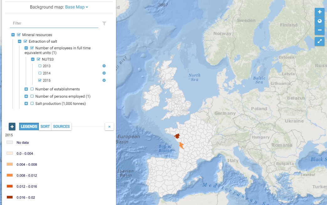
This map presents all layers corresponding to "Extraction of salt" activities in the Atlantic area. For more information about this NACE code : https://ec.europa.eu/eurostat/ramon/nomenclatures/index.cfm?TargetUrl=DSP_NOM_DTL_VIEW&StrNom=NACE_REV2&StrLanguageCode=EN&IntPcKey=18496034&IntKey=18496124&StrLayoutCode=HIERARCHIC&IntCurrentPage=1 Indicators collected are : Number of persons employed and number of employees in full time equivalent units per NUTS 3 unit of the Atlantic Area Salt production per Atlantic NUTS3
-
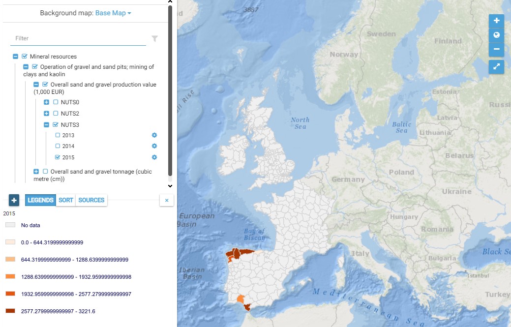
This map presents all layers corresponding to "Operation of gravel and sand pits" activities in the Atlantic area. For more information about this NACE code : https://ec.europa.eu/eurostat/ramon/nomenclatures/index.cfm?TargetUrl=DSP_NOM_DTL_VIEW&StrNom=NACE_REV2&StrLanguageCode=FR&IntPcKey=18495944&IntKey=18496004&StrLayoutCode=HIERARCHIC&IntCurrentPage=1 Indicators collected are : - Total number of jobs for Atlantic dredge areas - Overall production value from Atlantic dredge areas - Overall tonnage from Atlantic dredge areas
-
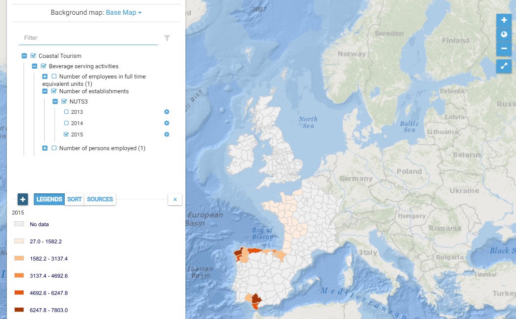
This map presents all layers corresponding to "Beverage serving activities" activities in the Atlantic area. For more information about this NACE code : https://ec.europa.eu/eurostat/ramon/nomenclatures/index.cfm?TargetUrl=DSP_NOM_DTL_VIEW&StrNom=NACE_REV2&StrLanguageCode=EN&IntPcKey=18514154&IntKey=18514184&StrLayoutCode=HIERARCHIC&IntCurrentPage=1 Indicators collected are : Number of persons employed and number of employees in full time equivalent units per NUTS 3 unit of the Atlantic Area Number of establishments per NUTS3 unit of the Atlantic Area
-
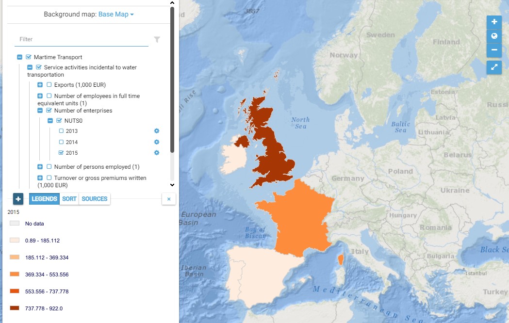
This map presents all layers corresponding to "Service activities incidental to water transportation" activities in the Atlantic area. For more information about this NACE code : https://ec.europa.eu/eurostat/ramon/nomenclatures/index.cfm?TargetUrl=DSP_NOM_DTL_VIEW&StrNom=NACE_REV2&StrLanguageCode=EN&IntPcKey=18513344&IntKey=18513404&StrLayoutCode=HIERARCHIC&IntCurrentPage=1 Indicators collected are : Business indicators per country Number of persons employed and number of employees in full time equivalent units per NUTS 3 unit of the Atlantic Area
-
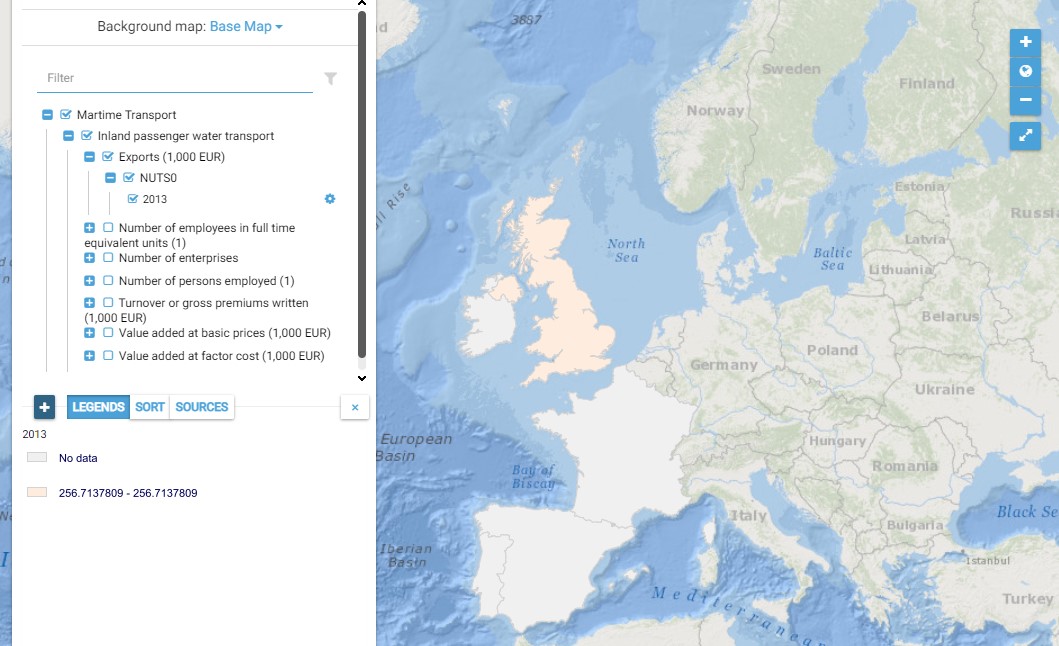
This map presents all layers corresponding to "Inland passenger water transport" activities in the Atlantic area. For more information about this NACE code : https://ec.europa.eu/eurostat/ramon/nomenclatures/index.cfm?TargetUrl=DSP_NOM_DTL_VIEW&StrNom=NACE_REV2&StrLanguageCode=EN&IntPcKey=18512804&IntKey=18512954&StrLayoutCode=HIERARCHIC&IntCurrentPage=1 Indicators collected are : Business indicators per country
-
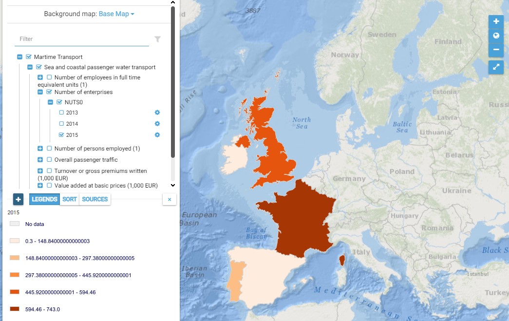
This map presents all layers corresponding to "Sea and coastal passenger water transport" activities in the Atlantic area. For more information about this NACE code : https://ec.europa.eu/eurostat/ramon/nomenclatures/index.cfm?TargetUrl=DSP_NOM_DTL_VIEW&StrNom=NACE_REV2&StrLanguageCode=EN&IntPcKey=18512804&IntKey=18512834&StrLayoutCode=HIERARCHIC&IntCurrentPage=1 Indicators collected are : Business indicators per country Number of persons employed and number of employees in full time equivalent units per NUTS 3 unit of the Atlantic Area Overall passenger traffic per main Atlantic port
-
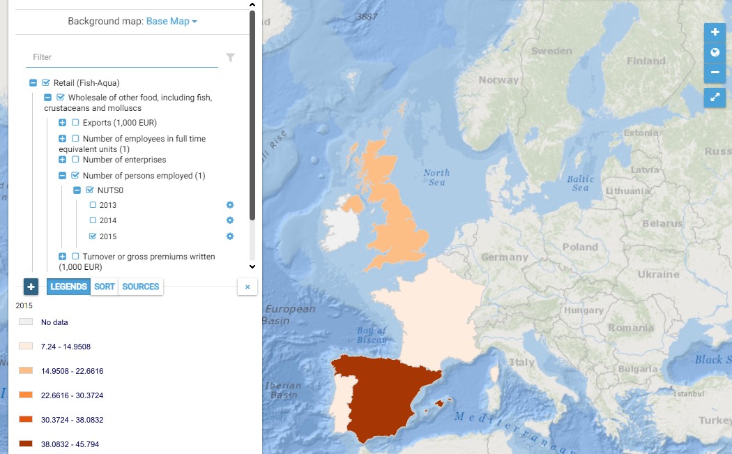
This map presents all layers corresponding to "Wholesale of other food, including fish, crustaceans and molluscs" activities in the Atlantic area. For more information about this NACE code : https://ec.europa.eu/eurostat/ramon/nomenclatures/index.cfm?TargetUrl=DSP_NOM_DTL_VIEW&StrNom=NACE_REV2&StrLanguageCode=EN&IntPcKey=18509714&IntKey=18509954&StrLayoutCode=HIERARCHIC&IntCurrentPage=1 Indicators collected are : Business indicators per country
-
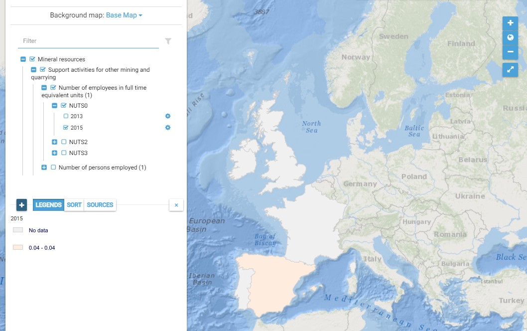
This map presents all layers corresponding to "Support activities for other mining and quarrying" activities in the Atlantic area. For more information about this NACE code : https://ec.europa.eu/eurostat/ramon/nomenclatures/index.cfm?TargetUrl=DSP_NOM_DTL_VIEW&StrNom=NACE_REV2&StrLanguageCode=EN&IntPcKey=18496274&IntKey=18496304&StrLayoutCode=HIERARCHIC&IntCurrentPage=1
-
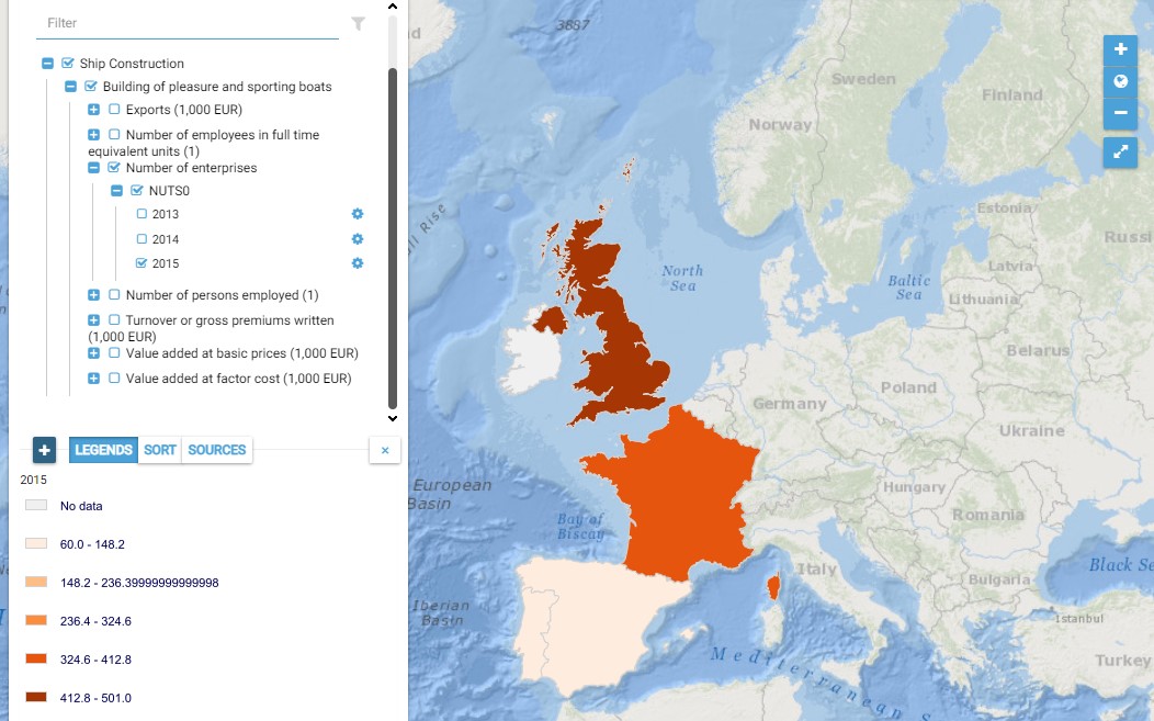
This map presents all layers corresponding to "Building of pleasure and sporting boats" activities in the Atlantic area. For more information about this NACE code : https://ec.europa.eu/eurostat/ramon/nomenclatures/index.cfm?TargetUrl=DSP_NOM_DTL_VIEW&StrNom=NACE_REV2&StrLanguageCode=EN&IntPcKey=18505424&IntKey=18505484&StrLayoutCode=HIERARCHIC&IntCurrentPage=1 Indicators collected are : Business indicators per country Number of persons employed and number of employees in full time equivalent units per NUTS 3 unit of the Atlantic Area