 Metadata catalogue
OBJ
Type of resources
Available actions
Topics
Keywords
Contact for the resource
Provided by
Years
Formats
-
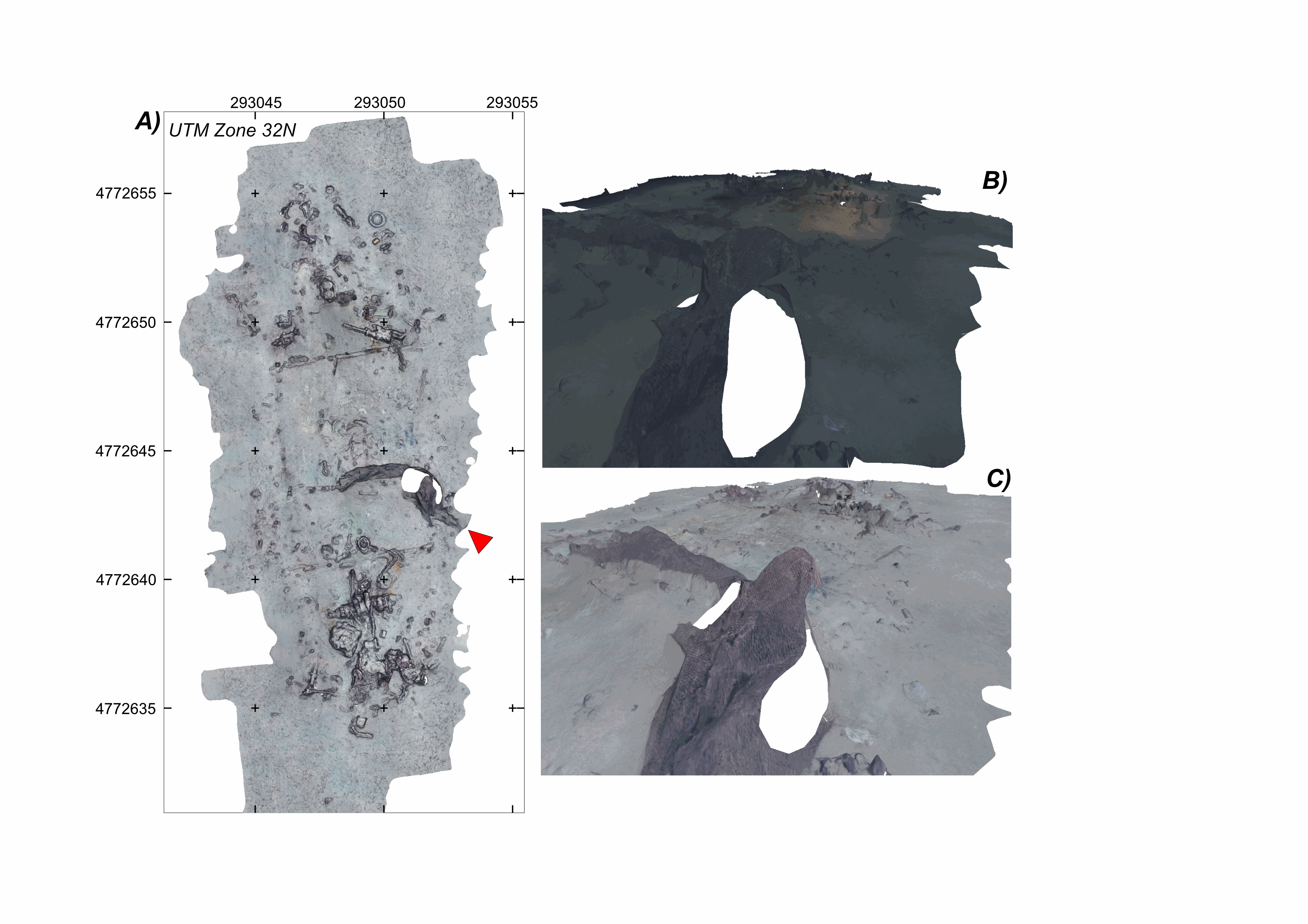
Litter site at the seafloor, off the southern French Mediterranean coast (43.078°N;6.458°E), at a water depth of ~600 m This litter field was surveyed using the HROV Arianne in 2017, deployed from N/O L’Europe, and equipped with a vertical electronic still camera. Two datasets are provided. First, the survey imagery, under a folder named carthorov_dump, that consists of 303 images (jpeg format) and an associated navigation file in dim2 format. Second, 2 folders with 3D textured models of the site (obj format), each with a kml file for georeferencing, and an geotiff orthomosaic. A first model is the result of processing imagery without data correction (folder WithoutAnyCorrection). A second model is processed with image colour correction (folder WithColorAndIlluminationCorrection). This dataset is one of several released with a paper by Arnaubec et al. (submitted March 2021, Computer and Geosciences) presenting the Matisse image processing software and the 3DMetrics Visualization and analysis software and released as open source (ref Github to come). Ref: Arnaubec, A., J. Escartín, J. Opderbecke, M. Matabos, N. Gracias, submitted, Underwater 3D terrain reconstruction from video or still imagery: Processing and exploitation software (MATISSE \& 3DMETRICS), in prep., Computers and Geosciences.
-
Submarine fault scarp and traces of earthquake (Roseau Fault, French Antilles): 3D scene and imagery
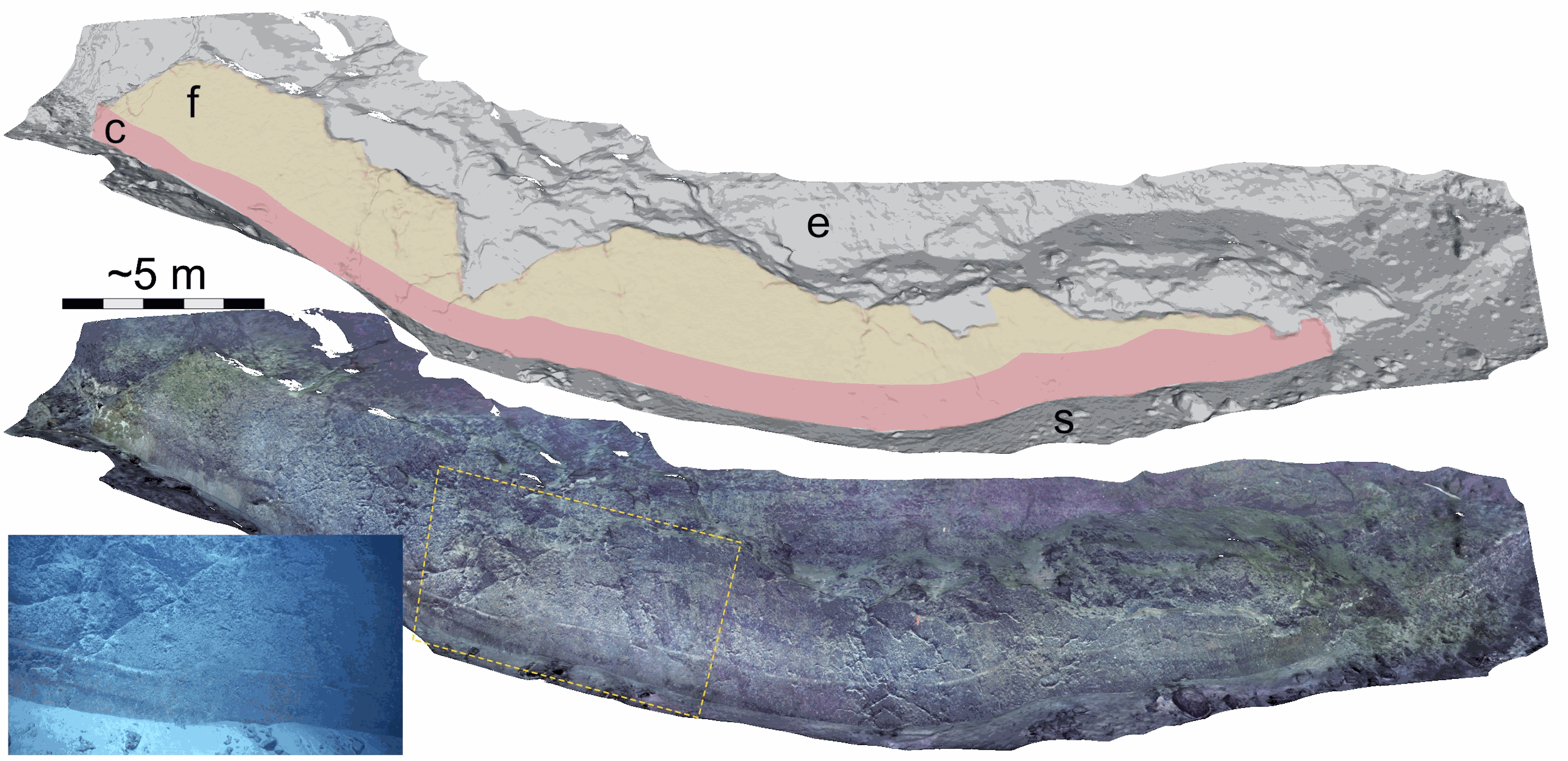
Fault scarp along the Roseau normal fault between Les Saintes and Dominica (French Antilles), at a water depth of 1100 m. This fault scarp is sub-vertical and at its base displays a marker that corresponds to the exposed fault plane during the 2004 Les Saintes Earthquake. The model shows here a coseismic displacement of ~1 m. This scarp was one of several surveyed along the Roseau Fault rupture during the Subsaintes cruise (https://doi.org/10.17600/17001000), with ROV Victor 6000 equipped with an HD Video camera. Two datasets are provided. First, the survey imagery, with a video (mp4 format) and an associated navigation file in txt format. Second, a 3D textured model of the site (obj format), together with the a kml file for georeferencing, and a geotiff orthomosaic. This dataset is one of several sets released with a paper by Arnaubec et al. (submitted March 2021, Computer and Geosciences) presenting the Matisse image processing software, and the 3DMetrics Visualization and analysis software (ref Github to come).
-
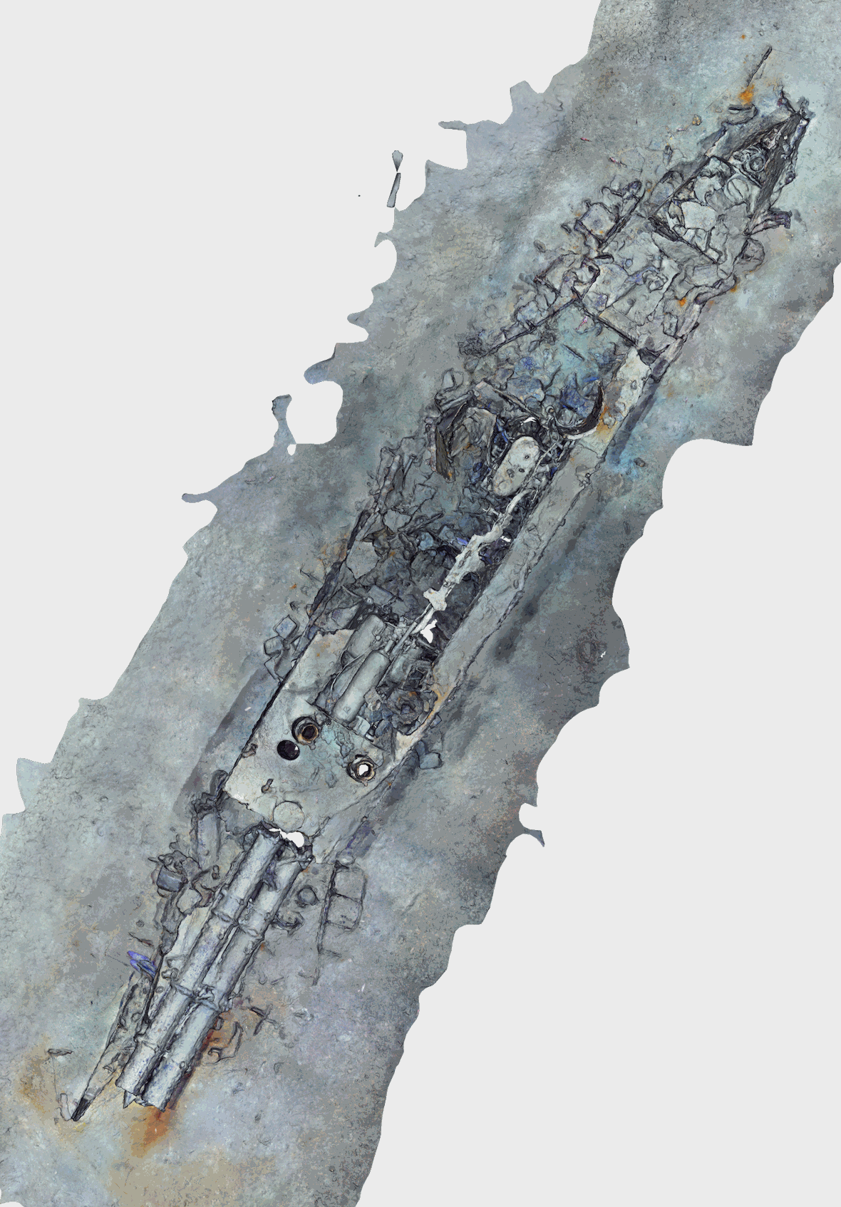
Abstract Torpedo boat wreck off-the southern French Mediterranean coast (43.124°N;6.523°E), at a water depth of ~476 m. This battle ship sank in 1903 (https://www.postenavalemilitaire.com/t11913-torpilleur-059-1881-1903) and the wreck is is ~20 m long and 3 m wide, raising ~2 m above the surrounding seafloor. This shipwreck was surveyed using the HROV Arianne in 2016, deployed from N/O L’Europe, and equipped with a vertical electronic still camera. Two datasets are provided. First, the survey imagery, that consists of 442 images (jpeg format) and an associated navigation file in dim2 format (torpdo_boat_imagery). Second, a 3D textured model of the site (obj format), together with the a kml file for georeferencing, and a geotiff orthomosaic (torpedo_boat_model). This dataset is one of several sets released with a paper by Arnaubec et al. (submitted to Computer and Geosciences) presenting the Matisse image processing software, and the 3DMetrics Visualization and analysis software (ref Github to come). Arnaubec, A., J. Escartín, J. Opderbecke, M. Matabos, N. Gracias, submitted, Underwater 3D terrain reconstruction from video or still imagery: Processing and exploitation software (MATISSE \& 3DMETRICS), Computers and Geosciences
-
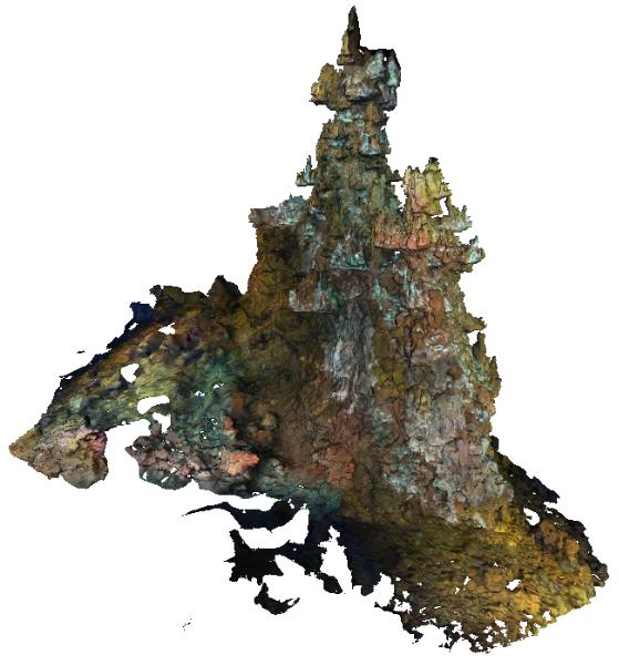
The Capelinhos hydrothermal vent site is a large edifice of 588 m² from its base. Located off axis, 1.5 km east of the central lava lake of the main Lucky Strike Hydrothermal Vent Field (mLSHVF), it is characterised by distinct geochemical and thermal conditions from the others mLSHVF edifices, with notably high iron concentrations compared to sites around the lava lake. The edifice has been surveyed with the remotely operated vehicle Victor6000 for inter-annual monitoring during the 2023 Momarsat cruise. Video transects were collected during dive 844-6 with a forward-looking camera and video sequences were used to build 3D models of the edifice using structure-from-motion techniques. A first dataset includes 2971 images extracted every 2 seconds from the videos. The images are time-stamped and linked to a navigation file, which is generated by interpolating navigation data at the corresponding timestamps. A second dataset includes a 3D textured model of the site (obj format) together with the a kml file for georeferencing. The ROV navigation file (.txt) is provided separately. Point : 37.28948183 (lat) -32.26413676 (long) -1663.487 (depth)
-

The Sintra hydrothermal vent site reconstructed in this dataset is 311.82 m². It is located in the North east of the main Lucky Strike Hydrothermal Vent Field (LSHF). The edifice has been surveyed with the remotely operated vehicle Victor6000 for inter-annual monitoring during the 2023 Momarsat cruise. Video transects were collected during dive 844-6 with a forward-looking camera and video sequences were used to build a 3D model of the edifice using structure-from-motion techniques. A first dataset includes 1561 images extracted every 2 seconds from the videos. The images are time-stamped and linked to a navigation file, which is generated by interpolating navigation data at the corresponding timestamps. A second dataset includes a 3D textured model of the site (obj format) together with the a kml file for georeferencing. The ROV navigation file (.txt) is provided separately. Point : 37.2921244612 (lat) -32.2750499167 (long) -1612.34 (depth)