 Metadata catalogue
NC, NETCDF
Type of resources
Available actions
Topics
Keywords
Contact for the resource
Provided by
Years
Formats
-
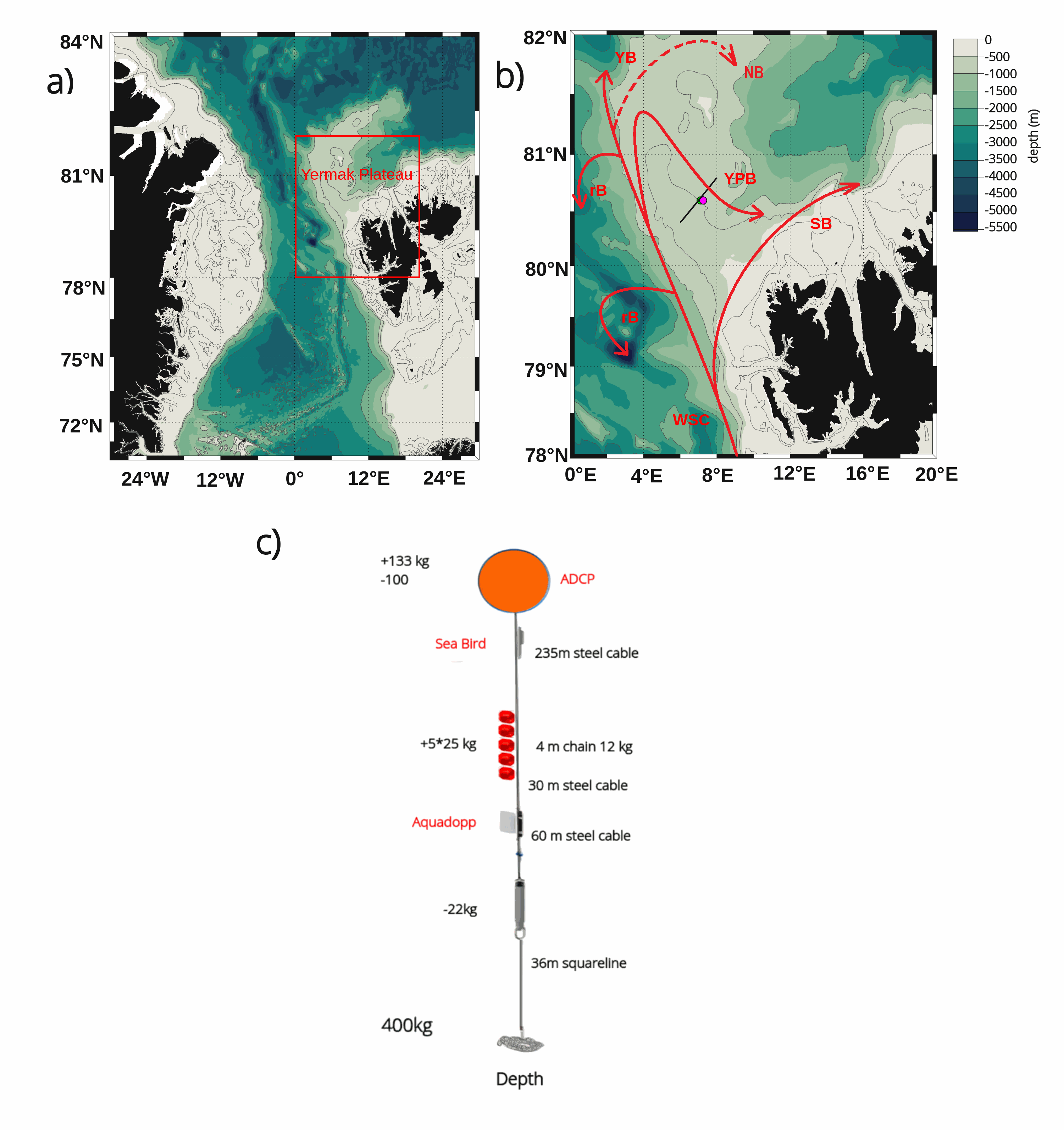
The mooring was deployed on 15 September 2017 from Norwegian Research Vessel Lance at 80.6°N and 7.26°E (depth of 730 m) in the Yermak Pass over the Yermak Plateau north of Svalbard. It comprised 3 instruments: an upward-looking RDI 75kHz, a Long Ranger Acoustic Doppler Current Profiler (ADCP) at 340 m with 16 m vertical resolution (25 bins of 16 m each) and a 2-hour sampling time; a Seabird SBE37 measuring temperature, salinity and pressure at 348 m with 10-minute sampling time; and an Aquadopp current meter at 645 m with a 2-hour sampling time. The mooring was retrieved on the 19 July 2020 by Norwegian Icebreaker K.V. Svalbard. The present dataset features: (i) the ADCP 50-hour smoothed daily velocities, conservative temperature and pressure time series interpolated every 10 meters within the 20-330m layer, (ii) the Aquadopp 50-hour smoothed daily velocities and pressure time series at 645 m; and (iii) the SBE37 50-hour smoothed daily conservative temperature, absolute salinity and pressure time series at 348 m.
-
Arctic Western Eurasian Basin: IAOOS 23 and IAOOS 24 ocean CTD-DO, CDOM and nitrate profiles in 2017
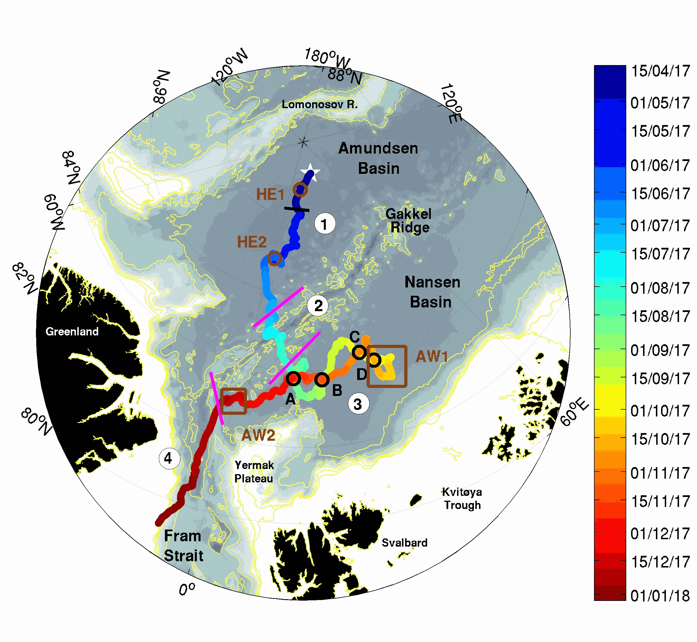
The two platforms IAOOS 23 and IAOOS 24 were deployed within 600 m from each other at the North Pole from the Russia-operated Barneo ice camp on April 12, 2017. They followed a meandering trajectory, reaching as far as 30°E in the Nansen Basin, before turning back to the western Fram Strait. On both IAOOS 23 and 24, the ocean profiler was a PROVOR SPI (from French manufacturer NKE) equipped with a Seabird SBE41 CTD (Conductivity, Temperature, Depth) and a dissolved oxygen (DO) Aandera 4330 optode. For the first time, the profiler on IAOOS 23 also carried biogeochemical sensors. It featured a bio-optics sensor suite and a submersible ultraviolet nitrate analyzer (SUNA, Satlantic-Seabird Inc.). The bio-optics sensor suite (called Pack Rem A) combines a three-optical-sensor instrument (ECO Triplet, WET Labs Inc.) and a multispectral radiometer (OCR-504, Satlantic Inc.). The present dataset is composed of CTD-DO data from IAOOS 23 and 24, corrected from the thermal lag and the sensor lag, despiked and interpolated vertically every 0.5 m. It also comprises nitrate concentrations from the SUNA and CDOM fluorescence from the WETLabs ECO sensor on IAOOS 23. Other biogeochemical data will be added to this dataset. The profilers were set to perform two upward profiles a day from 250 m (IAOOS 23) and 350 m (IAOOS 24) upward starting at approximately 6 am and 6 pm. They provided a unique 8-month long dataset, gathering a total of 793 profiles of the temperature, salinity and oxygen (upper 350m) and 427 profiles of CDOM and nitrates concentrations (upper 250m).
-
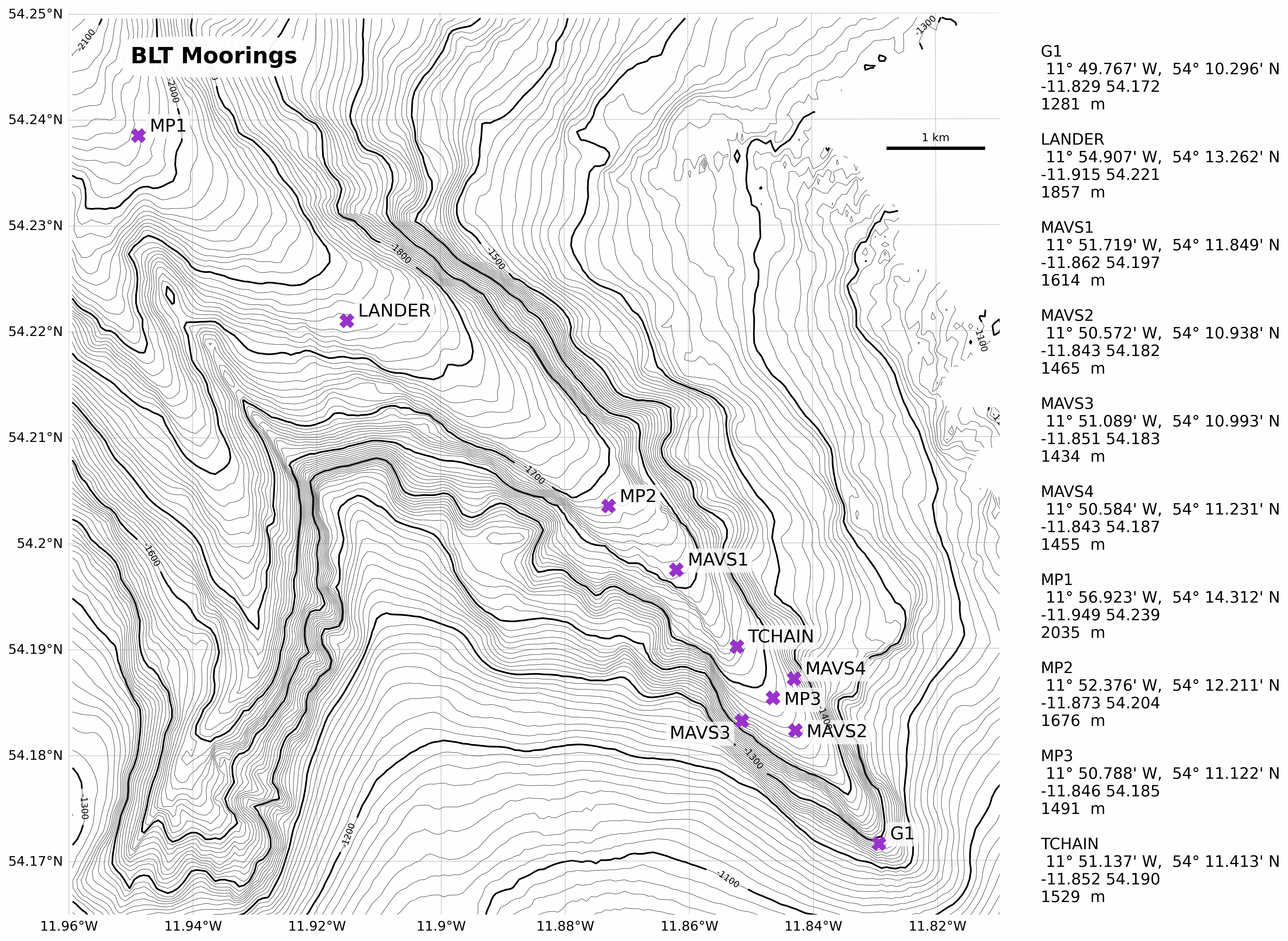
These data were collected as part of the Boundary Layer Turbulence and Abyssal Recipes (BLT Recipes) Experiment which focused on near-bottom processes within a continental slope canyon on the eastern side of the Rockall Trough, off Ireland. This specific dataset contains a bathymetry product based on data collected with the shipboard multibeam on RRS Discovery during cruises in 2021 and 2022.
-
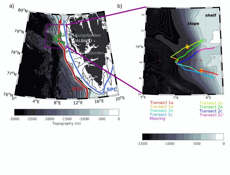
The SeaExplorer glider Sea028 was deployed from the research vessel R/V Lance on the 24 July 2017 at 78.65°N, 9.70°E, on the western slope of Svalbard. The glider was recovered on 7 August 2017 at 79.99°N, 9.51°E. It performed six crossing of the western Svalbard slope. The glider was equipped with a GPCTD (Glider Payload Conductivity Temperature Depth from SeaBird), a dissolved oxygen sensor (Sea Bird SBE43F), and an optical sensor measuring Chlorophyll a (470/695 nm), Colored Dissolved Organic Matter (CDOM, 370/460 nm), and the total particle concentration or backscatter (backscattering at 700 nm) (EcoPuck from Wetlabs). The dataset is composed of the data corrected from the thermal lag and the sensor lag, despiked and interpolated every 1m. The profiles are separated. Please note that the oxygen data are not accurate for the second half of the time series (sensor bias).
-
The SeaExplorer glider Sea028 was deployed from the research vessel R/V Lance on the 15 September 2017 at 79.5°N, 8.6°E, on the western slope of Svalbard. The glider was recovered on 23 September 2017 at 80.62°N, 13.83°E.The glider was equipped with a GPCTD (Glider Payload Conductivity Temperature Depth from SeaBird), a dissolved oxygen sensor (Sea Bird SBE43F), and an optical sensor measuring Chlorophyll a (470/695 nm), Colored Dissolved Organic Matter (CDOM, 370/460 nm), and the total particle concentration or backscatter (backscattering at 700 nm) (EcoPuck from Wetlabs). The dataset is composed of the data corrected from the thermal lag and the sensor lag, despiked and interpolated every 1m. The profiles are separated.
-
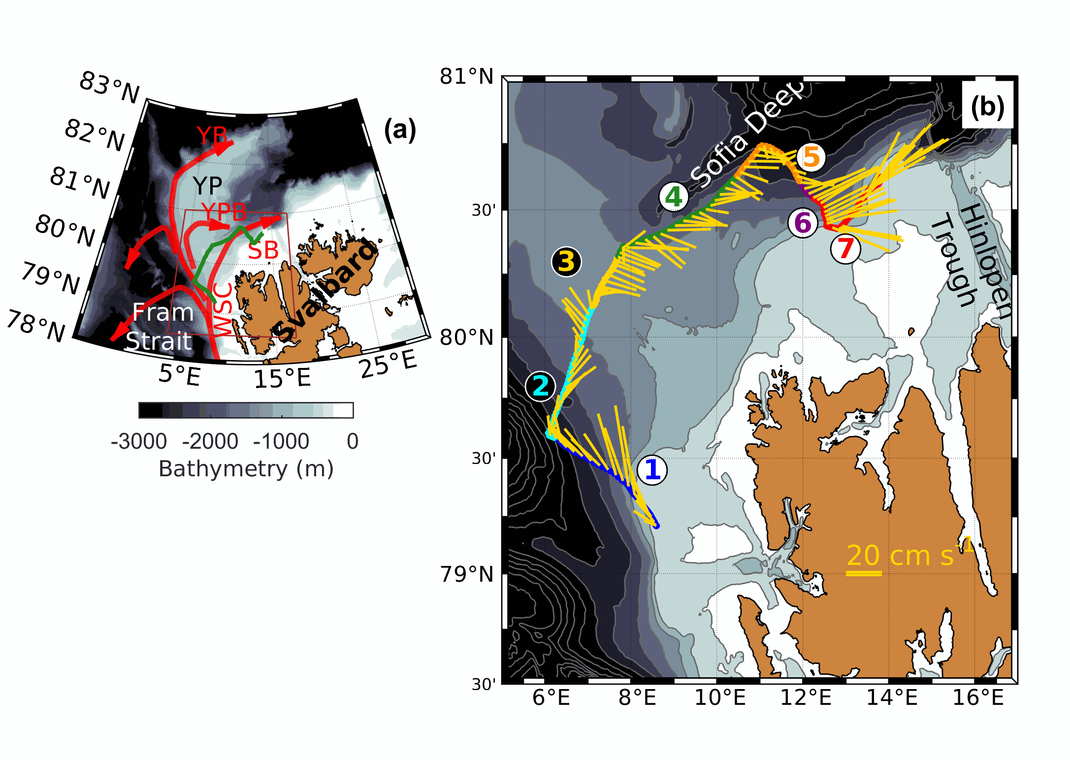
Mooring data at Yermak Pass from September 2017 to July 2020 : raw and 50 hr high pass filtered data

The mooring was deployed on 15 September 2017 from Norwegian Research Vessel Lance at 80.6°N and 7.26°E (depth of 730 m) in the Yermak Pass over the Yermak Plateau north of Svalbard. It comprised 3 instruments: an upward-looking RDI 75kHz, a Long Ranger Acoustic Doppler Current Profiler (ADCP) at 340 m with 16 m vertical resolution (25 bins of 16 m each) and a 2-hour sampling time; a Seabird SBE37 measuring temperature, salinity and pressure at 348 m with 10-minute sampling time; and an Aquadopp current meter at 645 m with a 2-hour sampling time. The mooring was retrieved on the 19 July 2020 by Norwegian Icebreaker K.V. Svalbard. The present dataset features: The ADCP 50-hour high pass filtered velocities and the Aquadopp 50-hour high pass filtered velocities.
-
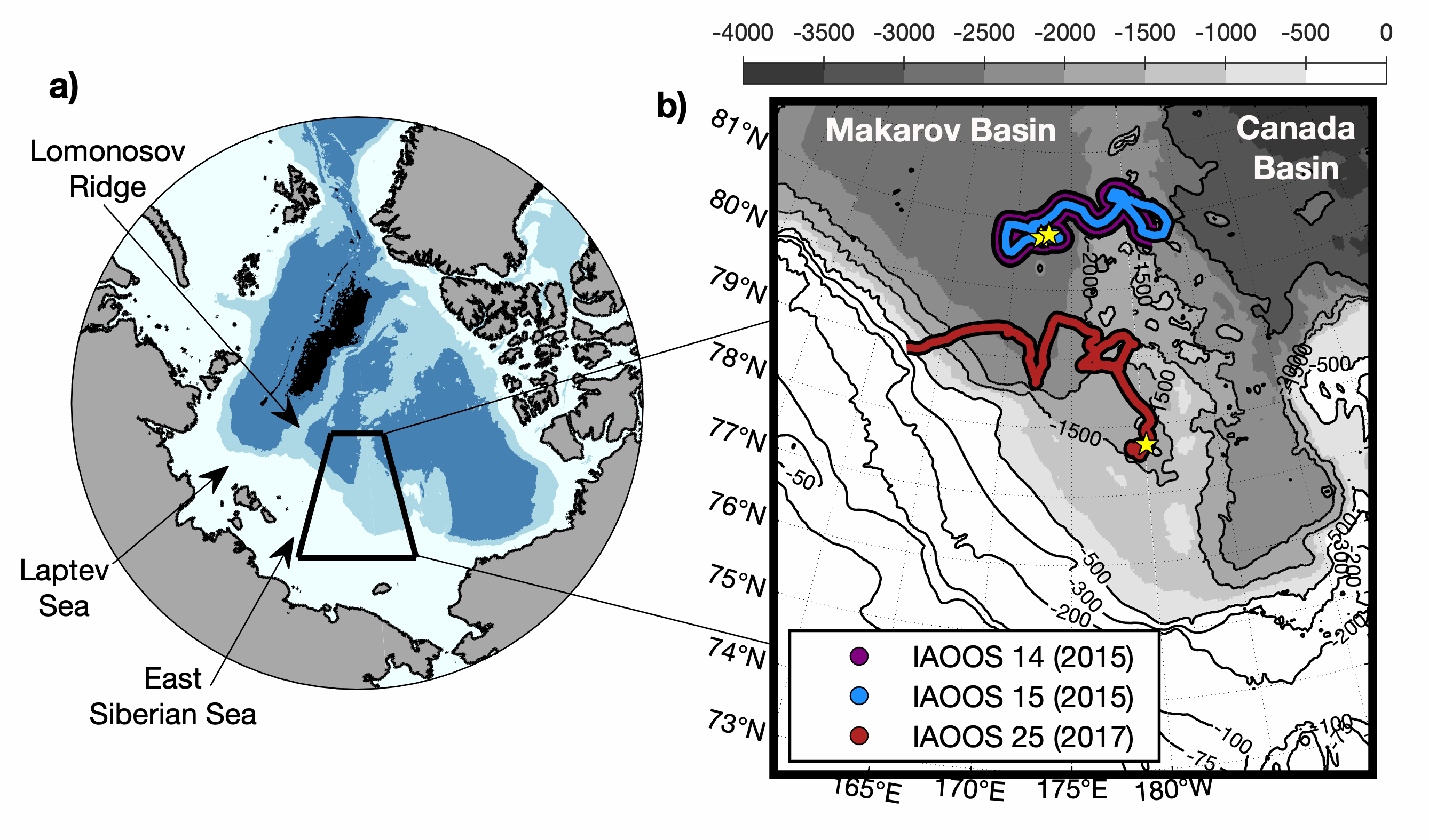
IAOOS14, IAOOS15 and IAOOS25 were deployed from the Korean Icebreaker R/V Araon during cruises in the northern Chukchi Sea. IAOOS14 and IAOOS15 were deployed 300 m apart on the same floe on 12 August 2015 in the Makarov Basin (80.8°N;173°E) and they drifted together remaining always less than 6 km apart. IAOOS25 was deployed on 15 August 2017 south-west Mendeleev Ridge (77.7°N;180°E) and drifted westward to the continental slope of the East Siberian Sea. IAOOS14 and IAOOS25 stopped transmitting on 9 October 2015 and 19 November 2017 respectively, likely due to the loss of their profilers while crossing relatively shallow bathymetry. IAOOS15 dataset ends in 15 October 2015. Ocean profilers were PROVOR SPI (from French manufacturer NKE) equipped with a Seabird SBE41 CTD (Conductivity, Temperature, Depth) and a dissolved oxygen (DO) Aandera 4330 optode. The profilers were set to perform two upward profiles a day from 800 m (IAOOS 14), 300 m (IAOOS 15) and 420 m (IAOOS 25), upward starting at approximately 6 am and 6 pm. The present dataset is composed of CTD-DO data from IAOOS 14 and 15, and CTD data from IAOOS 25 in the Makarov Basin, corrected from salinity errors and interpolated vertically every 0.5 m.
-

The Gambier lagoon has a diamond-shaped form and surrounds seven high islands that are very exposed to the ocean. It is bordered by a barrier reef, which is submerged along the southern and western sides and by an intertidal to emerged barrier reef along the northern and eastern sides. The northern side is cut in some sections by several hoa, (shallow passages) allowing connections between the lagoon and the open ocean. The average depth of the domain is 25 m, with a maximum depth of 80 m along the southeastern coast of Mangareva Island. The bathymetry is complex, forming several basins, including the Rikitea enclosed lagoon, which is bordered by Mangareva and Aukena islands. The bathymetry of the Gambier Islands lagoon was generated using three data sources: SHOM soundings acquired in the 1960s, multi-beam data from Geopolynesie (5 m resolution) collected between 2020 and 2021, and satellite-derived bathymetry (SDB) at 10 m resolution using Sentinel-2 imagery to fill depth gaps in shallow areas. The final bathymetric grid was produced for implementation in the numerical hydrodynamic model MARS3D at a resolution of 100 m, using the compiled sounding datasets described above. The interpolation process included a Hanning low-pass filter applied five consecutive times for depths below 50 m, followed by an additional low-pass filter (ROMS) with a factor of 0.25.
-
Maupiti ("the Stuck Twins'') is a diamond-shaped island located in the western part of the Society archipelago in French Polynesia. The present study focuses on the data recovered over a single cross-barrier transect located in the south-west barrier during the MAUPITI HOE field campaign, from 5 to 18 July 2018. The studied area is representative of the reef structure observed along the 4km-long southwestern barrier reef, showing an alongshore-uniform structure exposed to swell approaching with weak incident angles, a healthy reef colony. In the cross-barrier direction, the reef displays a clear partitioning of bottom roughness that ranges from low-crested compact structures at the reef crest to higher and sparser coral bommies on the backreef. The experimental setup was specifically designed to analyse and differentiate the dynamics over three roughness-contrasting sections found over the barrier reef.
-
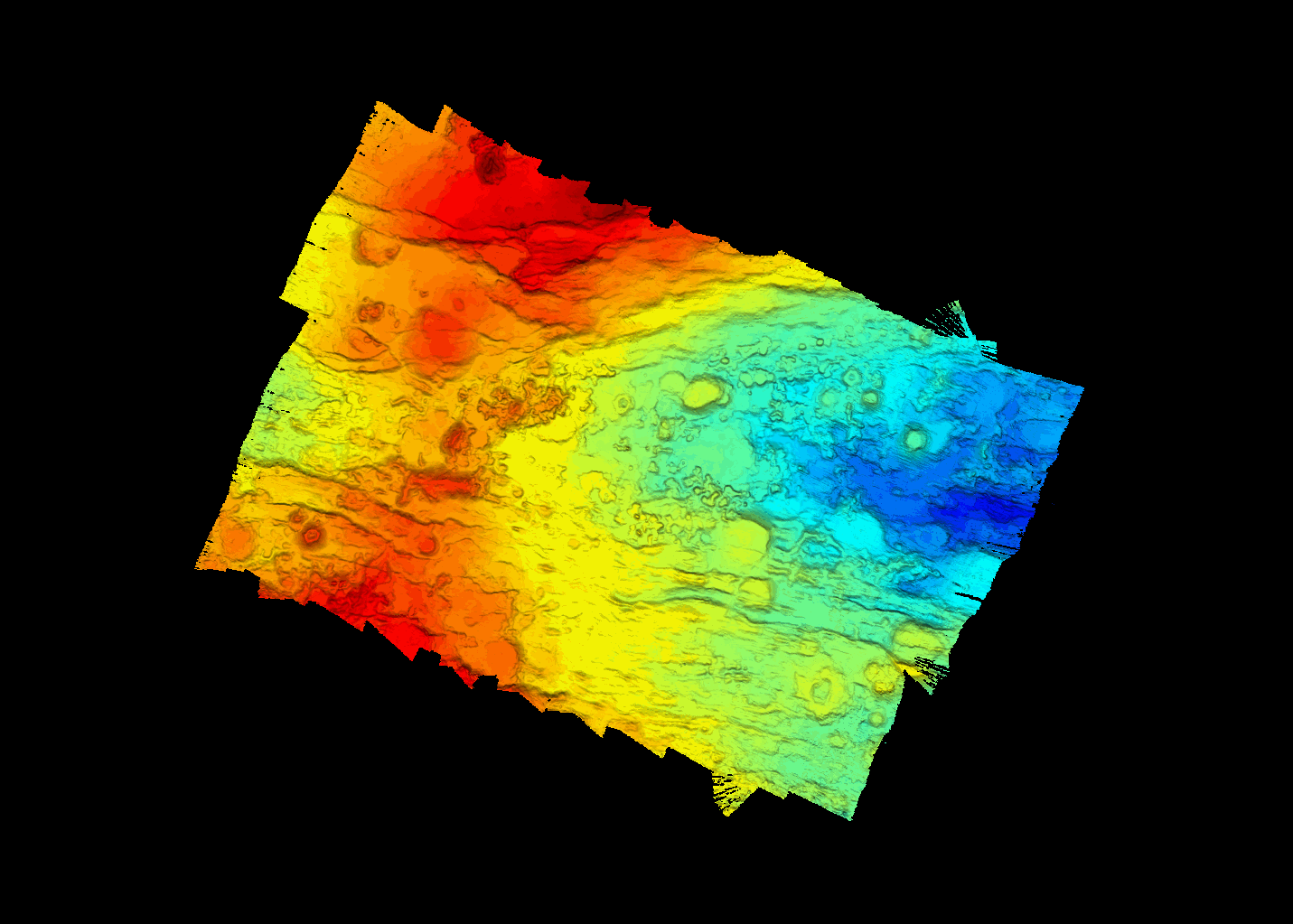
A MBES acoustic coverage of the PE-1 segment of the SWIR (South West Indian Ridge), more specifically in the vicinity of the dredge 5 location of the SWIFT cruise (2001), was carried out during the SWINGS cruise (https://doi.org/10.17600/18001925) with the French research vessel Marion Dufresne in 2021. SWINGS data were acquired with the hull-mounted multibeam echosounder Kongsberg EM122 12 kHz using an optimised configuration for bathymetry data collection: vessel speed of 5 knots, dual swath, CW signal and an angular opening of 120°. Acoustic data were processed with GLOBE software (https://doi.org/10.17882/70460) to provide a high-resolution bathymetry map (grid resolution of 15 m).