 Metadata catalogue
1
Type of resources
Available actions
Topics
INSPIRE themes
Keywords
Contact for the resource
Provided by
Years
Formats
Representation types
Update frequencies
status
Scale
-
The data comprise unprocessed raw data (level 0 data) containing image and spectral data acquired by scanning of drillcores at SGU. Level 0 is typically the level at which raw hyperspectral data is captured during the scanning campaign and the data has not been processed i.e. no data correction, normalization or band subsetting has been performed on this data. The cameras in the scanner cover the visible-near infrared and short-wave infrared (VNIR-SWIR) and the long-wave infrared (LWIR). The combination of different infrared wavelength ranges increases the mineral detection capability. Objective information about the mineralogical composition of the drillcores is fundamental basics for interpretation and modeling of the rock and the geological evolution.
-
The data comprise image and spectral data acquired by scanning of drillcores at SGU. The cameras in the scanner cover the visible, short wavelength and long wavelength parts of the infrared spectrum. The combination of different infrared wavelength ranges increases the mineral detection capability. Objective information about the mineralogical composition of the drillcores is fundamental basics for interpretation and modeling of the rock and the geological evolution. Level 2 is a processing level where data has been prepared for further spectral processing and product generation. Note that mineral identification is not included in level 2. This requires further processing and interpretation of the data.
-
MIN4EU DB consists of two parts: Minerals Inventory data and Minerals Yearbook data. Minerals Inventory covers mineral occurrences and mines in Europe (onshore). The European Union has identified security of supply, improving environmental management and resource efficiency as key challenges for the raw materials sector. Data on the location and spatial distribution of primary and secondary raw materials in relation to exploration, exploitation, production and trading activities form the basis for decision-making in government and industry. Given the dynamic nature of such data, regular updates of comprehensive, reliable and harmonized information across borders are required, as there are several sources of non-harmonized data with different coverages developed over the last decades by national and international projects for different purposes. Data have been prepared and collected in the projects Minerals4EU, EURare, ProSUM, ORAMA, RESEERVE and MINTELL4EU, and others and are shared in the European Geological Data Infrastructure (EGDI).
-
Mediterranean and Black Sea fisheries feature a great variety of target species, vessels and fishing gears and play an important socioeconomic role in the whole region. The mandate of the General Fisheries Commission for the Mediterranean (GFCM) is to ensure the sustainability of fisheries activities through the adoption of adequate management measures. The assessment of the size and state of the stocks exploited by fisheries is one of the pillars of modern management. The GFCM as the responsible Regional Fisheries Management Organisations (RFMO) of the Mediterranean and Black Sea has established permanent working groups on dermersal and small pelagic fish species where fisheries scientists perform their analysis and provide the best scientific advice to better manage fisheries and fish stocks. The groups, in cooperation with regional programs under the Regional Sea Conventions, set standards and guidelines for the collection, transmission and analysis of these data.
-
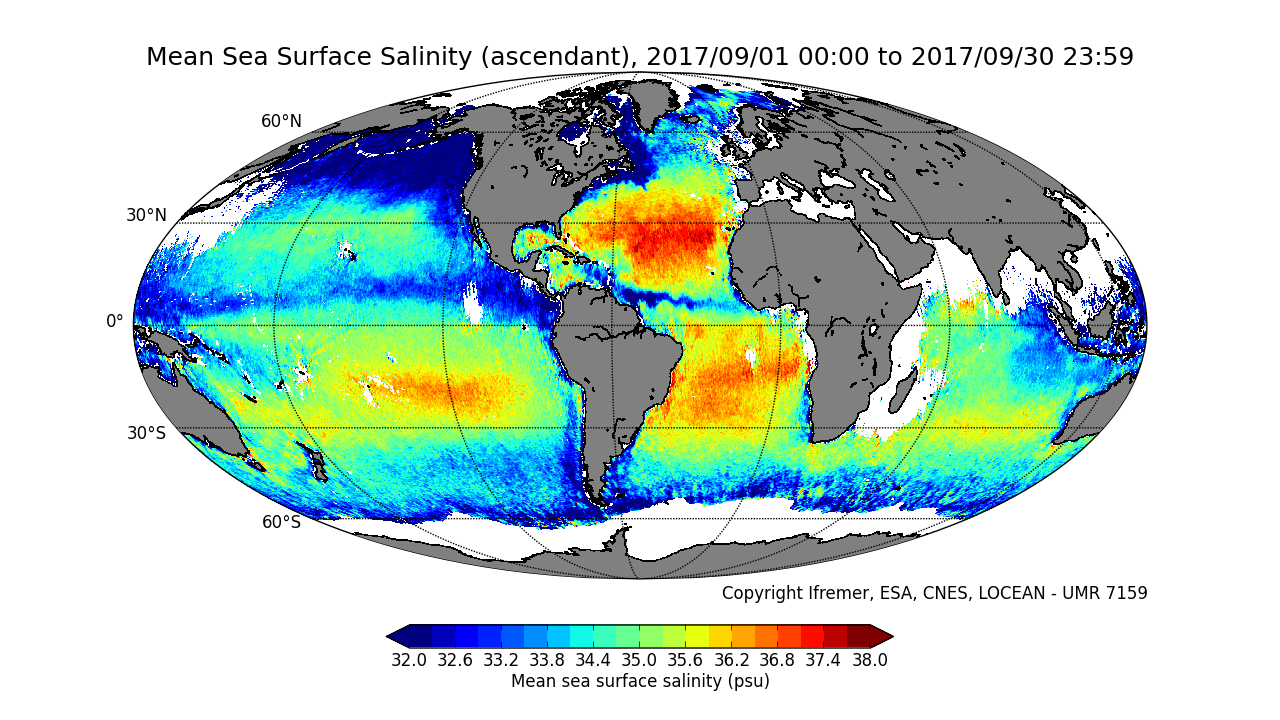
This product contains average 10 days & monthly salinity field based on L2P products, ascending and descending orbits being processed separately. ** This product is no longer available, see below **
-
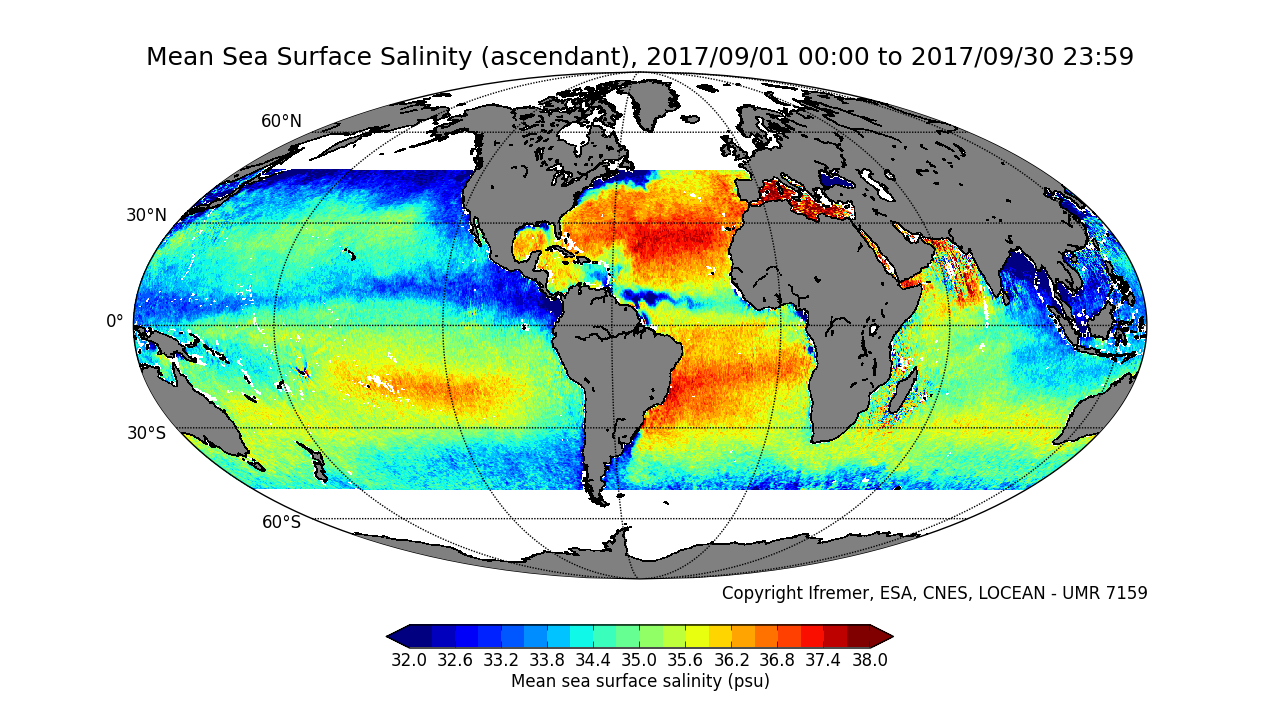
This product contains average 10 days & monthly salinity field corrected from land-sea contamination and latitudinal bias, based on L2Q products, ascending and descending orbits being processed separately. ** This product is no longer available, see below **
-
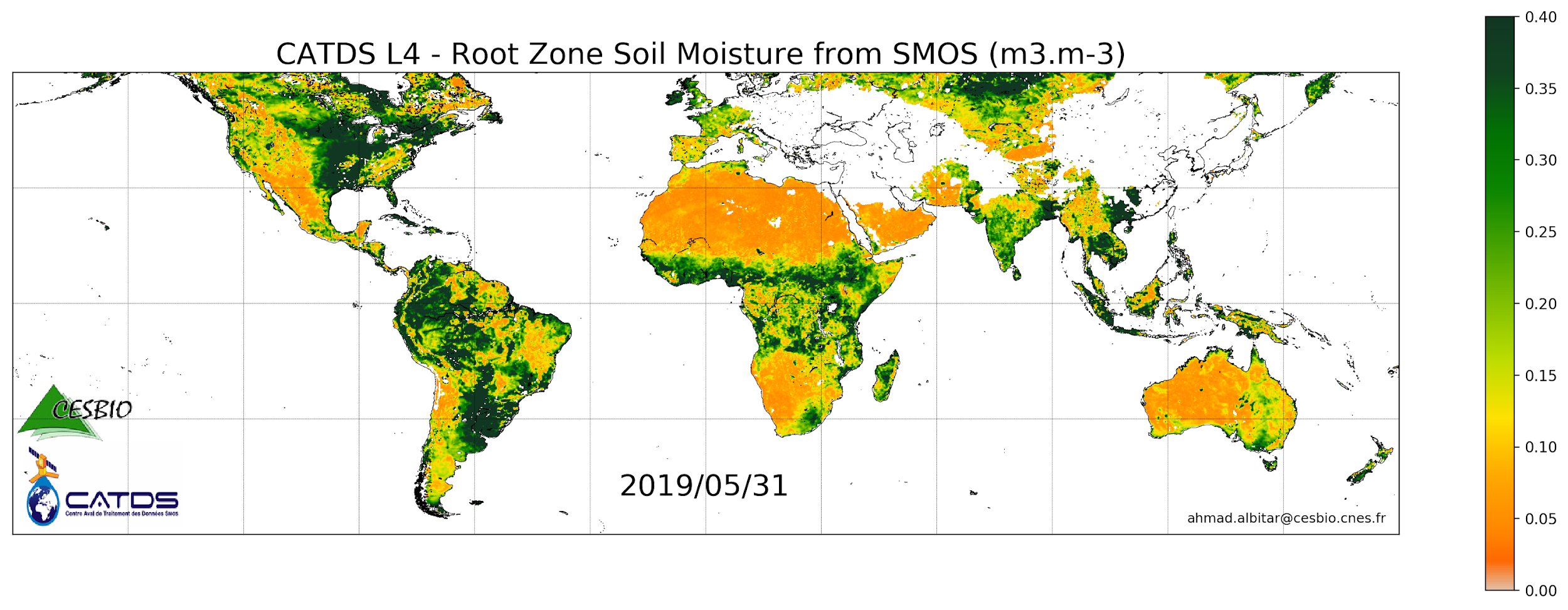
This product is a daily product of root zone soil moisture representative of the 0-1 m depth of the soil. Only descending orbits are processed.
-
Samba contains information on drilling and geophysical surveys on Danish territory, carried out according to license under the Danish underground law. That is: seismic surveys as well as boreholes for exploration, delimitation and production wells concerning oil/gas, geothermal energy, gas storage and salt as well as scientific drilling. The data sets contain technical, administrative and geological information from drillings and geophysical measurements undertaken in boreholes (boreholelogs and reports) as well as metadata (location, recording and processing parameters, etc.) for seismic studies. Data are reported by the companies who carries out the drillings and surveys. The database is updated on an ongoing basis.
-
Jupiter is GEUS ' nationwide database for groundwater, drinking water, raw materials, environmental and geotechnical data. The database is the single public data base in the field and is included in the National Environmental Portal. The database is publicly available.
-
This product contains average 10 days & monthly salinity field based on L2P products, mixing ascending and descending orbits. ** This product is no longer available, see below **