 Metadata catalogue
1981
Type of resources
Available actions
Topics
INSPIRE themes
Keywords
Contact for the resource
Provided by
Years
Formats
Representation types
Update frequencies
status
Scale
-
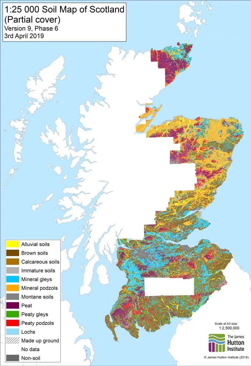
This is the digital dataset which was created by digitising the Soils of Scotland 1:25,000 Soil maps and the Soils of Scotland 1:25,000 Dyeline Masters. The Soils of Scotland 1:25,000 Soil maps were the source documents for the production of the Soils of Scotland 1:63,360 and 1:50,000 published map series. The classification is based on Soil Associations, Soil Series and Phases which reflect parent material, major soil group, and soil sub-groups, drainage and (for phases), texture, stoniness, land use, rockiness, topography and organic matter. Phases are not always mapped. In general terms this dataset primarily covers the cultivated land of Scotland but also includes some upland areas . Not all of the available source documents have been digitised. Should there be a requirement for other areas to be captured, the Internal Contact should be contacted in the first instance. Attribute definitions: The attributes on each map (coverage) are specific to that map sheet, but in general terms the following categories are mapped: soil association, soil series, parent material, soil complexes, soil phases, skeletal soils, alluvial soils, organic soils, miscellaneous soils, mixed bottom land, built-up area, quarries/disturbed ground, collieries/bings, golf courses.
-

The systematic survey of the soils of Scotland was commenced in 1947 by staff of the Macaulay Institute for Soil Research. This dataset is the digital (vector) version of the Soils of Scotland 1:250,000 maps, which is a generalised soil map, partly derived from a 1:50,000 map of the soils of Scotland. This dataset is an inventory of the soils of Scotland and was intended for use by planners etc. This dataset has the soil lines extrapolated over the built-up areas. The soil classification used was updated in 2013 to provide a unified classification across all Soil Survey of Scotland soil maps and profile datasets(UCSS).Version 1.1 of the data includes both the original 1984 and the 2013 soil classification.
-

The Land Capability Classification for Agriculture has as its objective the presentation of detailed information on soil, climate and relief in a form which will be of value to land use planners, agricultural advisers, farmers and others involved in optimising the use of land resources. The classification ranks land on the basis of its potential productivity and cropping flexibility determined by the extent to which its physical characteristics (soil, climate and relief) impose long term restrictions on its agricultural use. THE CLASSES Class 1. Land capable of producing a very wide range of crops with high yields Class 2. Land capable of producing a wide range of crops with yields less high than Class 1. Class 3. Land capable of producing good yields from a moderate range of crops. Class 4. Land capable of producing a narrow range of crops. Class 5. Land suited only to improved grassland and rough grazing. Class 6. Land capable only of use as rough grazing. Class 7. Land of very limited agricultural value. THE DIVISIONS A division is a ranking within a class. As the requirements of the crops suited to Classes 1 and 2 are fairly stringent, land in these classes has inherently low degrees of internal variability and no divisions are present. The requirements of crops grown in the remaining classes are less rigorous, consequently land included is more variable in character.
-

The National Soils Inventory for Scotland (NSIS1) dataset has been collected using sampling points arranged as a 10 km grid. A wide range of attributes are described, measured and analysed for each site. These range from contextual information describing the surrounding landscape (such as slope and vegetation), down to detailed chemical analyses of each horizon within the soil profile. There are 721 sites in total where soil occurs; where there is no soil at a particular 10 km sampling point, this point has not been included.
-

Planta Aerofotogramétrica à escala 1:2000 da Zona Central do Concelho de Vale de Cambra, composta por 20 plantas
-
Carta Geomorfologica d'Italia alla scala 1:25.000: sono disponibili le banche dati di n.4 fogli, a partire dal 1981 al 2005.
-
.gif)
La BD Scan-Géol-50 est la base de données géoréférencées des cartes géologiques "papier" à 1/50 000.
-
La BD Scan-Géol-50 est la base de données géoréférencées des cartes géologiques "papier" à 1/50 000.
-
La BD Scan-Géol-50 est la base de données géoréférencées des cartes géologiques "papier" à 1/50 000.
-
La BD Scan-Géol-50 est la base de données géoréférencées des cartes géologiques "papier" à 1/50 000.