 Metadata catalogue
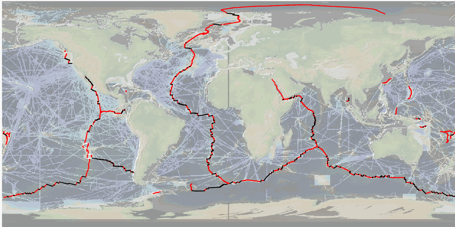
MAPRIDGES: Global Database of Mid-Oceanic Ridges Segments and Transform Faults
The precise location and geometry of oceanic spreading centers and associated transform faults or discontinuities' boundary has fundamental implications in our understanding of oceanic accretion, the accommodation of deformation around rigid lithospheric blocks, and the distribution of magmatic and volcanic processes. The now widely used location of mid oceanic ridges worldwide, published by P. Bird in 2003, can be updated based on recent publicly available and published ship-based multibeam swath bathymetry data (100-m resolution or better), now available to ~25% of the ocean seafloor, but covering a significant proportion of the mid-ocean ridge system (>70%).
Here we publish the MAPRIDGES database built under the coordination of CGMW (Commission for the Geological Map of the World), with a first version V1.0 (06/2024) that provides high resolution and up-to-date datasets of mid-ocean ridge segments and associated transform faults, and follow-up updates that will also include non-transform offsets.
The detailed mapping of individual mid oceanic ridge segments was conducted using GMRT (Ryan et al., 2009) (version 4.2 for MAPRIDGES V1.0), other publicly available datasets (e.g., NCEI, Pangaea, AWI), and existing literature. MAPRIDGES will be revised with the acquisition of additional datasets, new publications, and correction of any errors in the database.
The MAPRIDGE database was built in a GIS environment, where each feature holds several attributes specific to the dataset. We include three different georeferenced shapefile layers: 1) Ridge Segments, 2) Transform Faults, and 3) Transform Zones. The latest corresponds to zones of distributed strike-slip deformation that lack a well-defined fault localizing strain, but that are often treated as transform faults.
1) The Ridge Segments Layer contains 1461 segments with 9 attributes:
- AREA_LOCA: The Name of the Ridge System
- LOC_SHORT: The short form of the Ridge System using 3 characters
- LAT: The maximum latitude of the ridge segment
- LONG: the maximum longitude of the ridge segment
- LENGTH: the length of the ridge segment in meters
- CONFIDENCE: the degree of confidence on digitization based on the availability of high-resolution bathymetry data: 1 = low to medium confidence, 2 = high confidence
- REFERENCES: supporting references used for the digitization
- NAME_CODE: unique segment code constructed from the LOC_SHORT and LAT attributes in degree, minute, second coordinate format
- NAME_LIT: name of the segment from the literature if it exists
2) The Transform Fault Layer contains 260 segments with 4 attributes:
- NAME_TF: Name of the transform fault according to the literature
- LENGTH: length of the transform fault in meters
- LAT: The maximum latitude of the fault segment
- LONG: the maximum longitude of the fault segment
3) The Transform Zone layer contains 10 segments with 4 attributes:
- NAME_TF: Name of the transform zone according to the literature
- LENGTH: length of the transform fault in meters
- LAT: The maximum latitude of the fault segment
- LONG: the maximum longitude of the fault segment
To facilitate revisions and updates of the database, relevant information, corrections, or data could be sent to B. Sautter (benjamin.sautter@univ-ubs.fr ) and J. Escartín (escartin@geologie.ens.fr ).
|
|
Citation proposal
SAUTTER Benjamin (Laboratoire Geo-Ocean (UMR 6538), Université Bretagne Sud, Vannes, France Commission for the Geological Map of the World (CGMW), Paris, France) - ESCARTIN Javier (Laboratoire de Géologie (CNRS UMR8538), Ecole Normale Supérieure de Paris, PSL University, Paris, France Commission for the Geological Map of the World (CGMW), Paris, France) - PETERSEN Sven (GEOMAR, Helmholtz Centre for Ocean Research Kiel, Kiel, Germany) - GAINA Carmen (PHAB, Centre for Planet Habitability, Department of Geosciences, University of Oslo, Norway) - GRANOT Roi (Department of Earth and Environmental Sciences, Ben‐Gurion University of the Negev, Beer‐Sheva, Israel) - PUBELLIER Manuel (Laboratoire de Géologie (CNRS UMR8538), Ecole Normale Supérieure de Paris, PSL University, Paris, France Commission for the Geological Map of the World (CGMW), Paris, France) (2024) . MAPRIDGES: Global Database of Mid-Oceanic Ridges Segments and Transform Faults. https://services.mspdata.eu:/geonetwork/srv/api/records/seanoe:99981 |
Simple
- Date ( Publication )
- 2024-06-21
- Date ( Revision )
- 2025-05-22
- Other citation details
- Sautter Benjamin, Escartin Javier, Petersen Sven, Gaina Carmen, Granot Roi, Pubellier Manuel (2024). MAPRIDGES: Global Database of Mid-Oceanic Ridges Segments and Transform Faults. SEANOE. https://doi.org/10.17882/99981
Publisher
- Keywords ( Theme )
-
- Ridge segment , Transform Faults , Non Transform Offset , Transform Zone , Oceanic Plate Boundary , Digitization , High Resolution , Marine geology
- ODATIS aggregation parameters and Essential Variable names ( Theme )
-
- Bathymetry
- SeaDataNet Parameter Disciplines ( parameter )
-
- Marine geology
- Type de jeux de donnée ODATIS ( Theme )
-
- Aggregate data
- Use constraints
- Other restrictions
- Other constraints
- Metadata language
- English
- Topic category
-
- Oceans
))
- Distribution format
-
- SHP ( )
- DOC, DOCX ( )
- OnLine resource
-
MAPRIDGES_V1 [RESTRICTED] - 292 KB
MAPRIDGES_V1 [RESTRICTED] - 292 KB
- OnLine resource
-
README [RESTRICTED] - 25 KB
README [RESTRICTED] - 25 KB
- OnLine resource
- DOI of the product
- OnLine resource
- Seanoe
- Hierarchy level
- Dataset
- Statement
Metadata
- File identifier
- seanoe:99981 XML
- Metadata language
- English
- Character set
- UTF8
- Hierarchy level
- Dataset
- Date stamp
- 2025-05-22
- Metadata standard name
- ISO 19115:2003/19139
- Metadata standard version
- 1.0
Overviews
Provided by
