Metadata catalogue
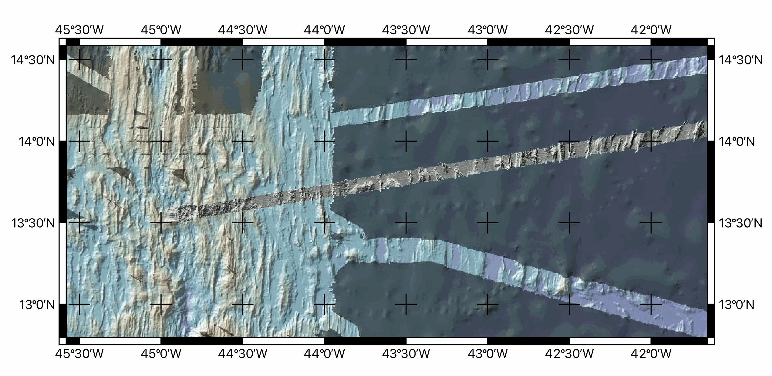
Transit shipboard bathymetry from the ODEMAR cruise (Pourquoi Pas?, 2013)
Multibeam bathymetry data, gridded at ~100m, acquired around during the transit towards the Mid-Atlantic ridge axis (13°20'N and 13°30'N oceanic detachments area) during the ODEMAR cruise (2013). Bathymetric data was acquired by the PourQUoi Pas? multibeam system (RESON SEABAT 7150).
Data is provided as geotiffs (WGS84)
ODM_transit_16Nov.tif
Extent -27.8375538800000015,16.3530121699999995 : -26.3755538800000018,16.6860121699999979 Width 1463 Height 334 Data type Float32 - Thirty two bit floating point GDAL Driver Description GTiff GDAL Driver Metadata GeoTIFF Dataset Description /Users/jescartin/WORK/Proyectos/ODEMAR/DATA/Bathygrids/Transit/ODM_transit_16Nov.tif Compression PACKBITS Band 1 STATISTICS_MAXIMUM=-4139.5639648438 STATISTICS_MEAN=-4612.4823849892 STATISTICS_MINIMUM=-4866.7373046875 STATISTICS_STDDEV=121.40234041923 STATISTICS_VALID_PERCENT=29.85 Scale: 1 Offset: 0 More information AREA_OR_POINT=Area TIFFTAG_SOFTWARE=MATLAB 9.14, Mapping Toolbox 5.5 Dimensions X: 1463 Y: 334 Bands: 1 Origin -27.8375538800000015,16.6860121699999979 Pixel Size 0.0009993164730006834189,-0.0009970059880239474058
ODM_transit_17Nov.tif
Extent -32.4955601099999996,15.5934151199999995 : -27.8195601099999976,16.4454151199999998 Width 4677 Height 853 Data type Float32 - Thirty two bit floating point GDAL Driver Description GTiff GDAL Driver Metadata GeoTIFF Dataset Description /Users/jescartin/WORK/Proyectos/ODEMAR/DATA/Bathygrids/Transit/ODM_transit_17Nov.tif Compression PACKBITS Band 1 STATISTICS_APPROXIMATE=YES STATISTICS_MAXIMUM=-4458.8168945312 STATISTICS_MEAN=-5144.8000932272 STATISTICS_MINIMUM=-5562.1850585938 STATISTICS_STDDEV=164.55246561258 STATISTICS_VALID_PERCENT=50.04 Scale: 1 Offset: 0 More information AREA_OR_POINT=Area TIFFTAG_SOFTWARE=MATLAB 9.14, Mapping Toolbox 5.5 Dimensions X: 4677 Y: 853 Bands: 1 Origin -32.4955601099999996,16.4454151199999998 Pixel Size 0.0009997861877271759391,-0.0009988276670574447458
ODM_transit_18Nov.tif
Extent -36.9279732571747630,14.8264479347363469 : -32.4729732571747647,15.7054479347363465 Width 4456 Height 880 Data type Float32 - Thirty two bit floating point GDAL Driver Description GTiff GDAL Driver Metadata GeoTIFF Dataset Description /Users/jescartin/WORK/Proyectos/ODEMAR/DATA/Bathygrids/Transit/ODM_transit_18Nov.tif Compression PACKBITS Band 1 STATISTICS_APPROXIMATE=YES STATISTICS_MAXIMUM=-5171.58203125 STATISTICS_MEAN=-5712.1738558372 STATISTICS_MINIMUM=-5946.1611328125 STATISTICS_STDDEV=139.45706418798 STATISTICS_VALID_PERCENT=7.565 Scale: 1 Offset: 0 More information AREA_OR_POINT=Area TIFFTAG_SOFTWARE=MATLAB 9.14, Mapping Toolbox 5.5 Dimensions X: 4456 Y: 880 Bands: 1 Origin -36.9279732571747630,15.7054479347363465 Pixel Size 0.0009997755834829438748,-0.0009988636363636358394
ODM_transit_19Nov.tif
Extent -41.3188024399999989,14.0843680599999992 : -36.8828024399999990,14.9493680599999994 Width 4437 Height 866 Data type Float32 - Thirty two bit floating point GDAL Driver Description GTiff GDAL Driver Metadata GeoTIFF Dataset Description /Users/jescartin/WORK/Proyectos/ODEMAR/DATA/Bathygrids/Transit/ODM_transit_19Nov.tif Compression PACKBITS Band 1 STATISTICS_APPROXIMATE=YES STATISTICS_MAXIMUM=-4540.5317382812 STATISTICS_MEAN=-5176.2961468757 STATISTICS_MINIMUM=-5426.123046875 STATISTICS_STDDEV=183.14492125461 STATISTICS_VALID_PERCENT=7.674 Scale: 1 Offset: 0 More information AREA_OR_POINT=Area TIFFTAG_SOFTWARE=MATLAB 9.14, Mapping Toolbox 5.5 Dimensions X: 4437 Y: 866 Bands: 1 Origin -41.3188024399999989,14.9493680599999994 Pixel Size 0.0009997746224926751767,-0.0009988452655889147342
ODM_transit_20Nov.tif
Extent -44.9630377200000027,13.5018919999999998 : -41.3030377200000061,14.1828919999999989 Width 3661 Height 682 Data type Float32 - Thirty two bit floating point GDAL Driver Description GTiff GDAL Driver Metadata GeoTIFF Dataset Description /Users/jescartin/WORK/Proyectos/ODEMAR/DATA/Bathygrids/Transit/ODM_transit_20Nov.tif Compression PACKBITS Band 1 STATISTICS_APPROXIMATE=YES STATISTICS_MAXIMUM=-3173.7924804688 STATISTICS_MEAN=-4347.3027374804 STATISTICS_MINIMUM=-4821.65625 STATISTICS_STDDEV=276.6463937856 STATISTICS_VALID_PERCENT=42.31 Scale: 1 Offset: 0 More information AREA_OR_POINT=Area TIFFTAG_SOFTWARE=MATLAB 9.14, Mapping Toolbox 5.5 Dimensions X: 3661 Y: 682 Bands: 1 Origin -44.9630377200000027,14.1828919999999989 Pixel Size 0.0009997268505872703662,-0.000998533724340174662
|
|
Citation proposal
Escartin Javier (Laboratoire de Geologie, ENS/CNRS, Paris) (2023) . Transit shipboard bathymetry from the ODEMAR cruise (Pourquoi Pas?, 2013). https://services.mspdata.eu:/geonetwork/srv/api/records/seanoe:97230 |
Simple
- Date ( Publication )
- 2023-11-20
- Date ( Revision )
- 2025-04-03
- Other citation details
- Escartin Javier (2023). Transit shipboard bathymetry from the ODEMAR cruise (Pourquoi Pas?, 2013). SEANOE. https://doi.org/10.17882/97230
- Credit
- ODEMAR Cruise, funded by the Flotte Océanographique Française (FOF)
Publisher
- Keywords ( Theme )
-
- Multibeam bathymetry , seafloor , topography , faulting , Marine geology
- ODATIS aggregation parameters and Essential Variable names ( Theme )
-
- Bathymetry
- SeaDataNet Parameter Disciplines ( parameter )
-
- Marine geology
- Research Infrastructure ( Theme )
-
- IR-FOF
- Type de jeux de donnée ODATIS ( Theme )
-
- /Observational data/in-situ
- Use constraints
- Other restrictions
- Other constraints
- Not for navigation
- Date ( Publication )
- 2023
Publisher
Author
Author
Author
Author
Author
Author
- Association Type
- Cross reference
- Initiative Type
- dataset
- Date ( Publication )
- 2023
Publisher
Author
Author
Author
Author
- Association Type
- Cross reference
- Initiative Type
- dataset
- Date ( Publication )
- 2017
Publisher
Author
Author
- Association Type
- Cross reference
- Initiative Type
- dataset
- Date ( Publication )
- 2017
Publisher
Author
Author
Author
Author
- Association Type
- Cross reference
- Initiative Type
- dataset
- Association Type
- Cross reference
- Initiative Type
- Platform
- Metadata language
- English
- Topic category
-
- Oceans
))
- Distribution format
-
- GEOTIFF ( )
- OnLine resource
-
Processed data
Zipped file of gridded multibeam bathymetry, in GEOTIFF format, of processed grids of the transit of the ODEMAR cruise towards the ridge axis (grids split by days, 16, 17, 18, 19 and 20 Nov 2013) - 5 MB
- OnLine resource
- DOI of the product
- OnLine resource
- Seanoe
- Hierarchy level
- Dataset
- Statement
- Multibeam RESON SEABAT 7150
Metadata
- File identifier
- seanoe:97230 XML
- Metadata language
- English
- Character set
- UTF8
- Hierarchy level
- Dataset
- Date stamp
- 2025-04-03
- Metadata standard name
- ISO 19115:2003/19139
- Metadata standard version
- 1.0