Metadata catalogue
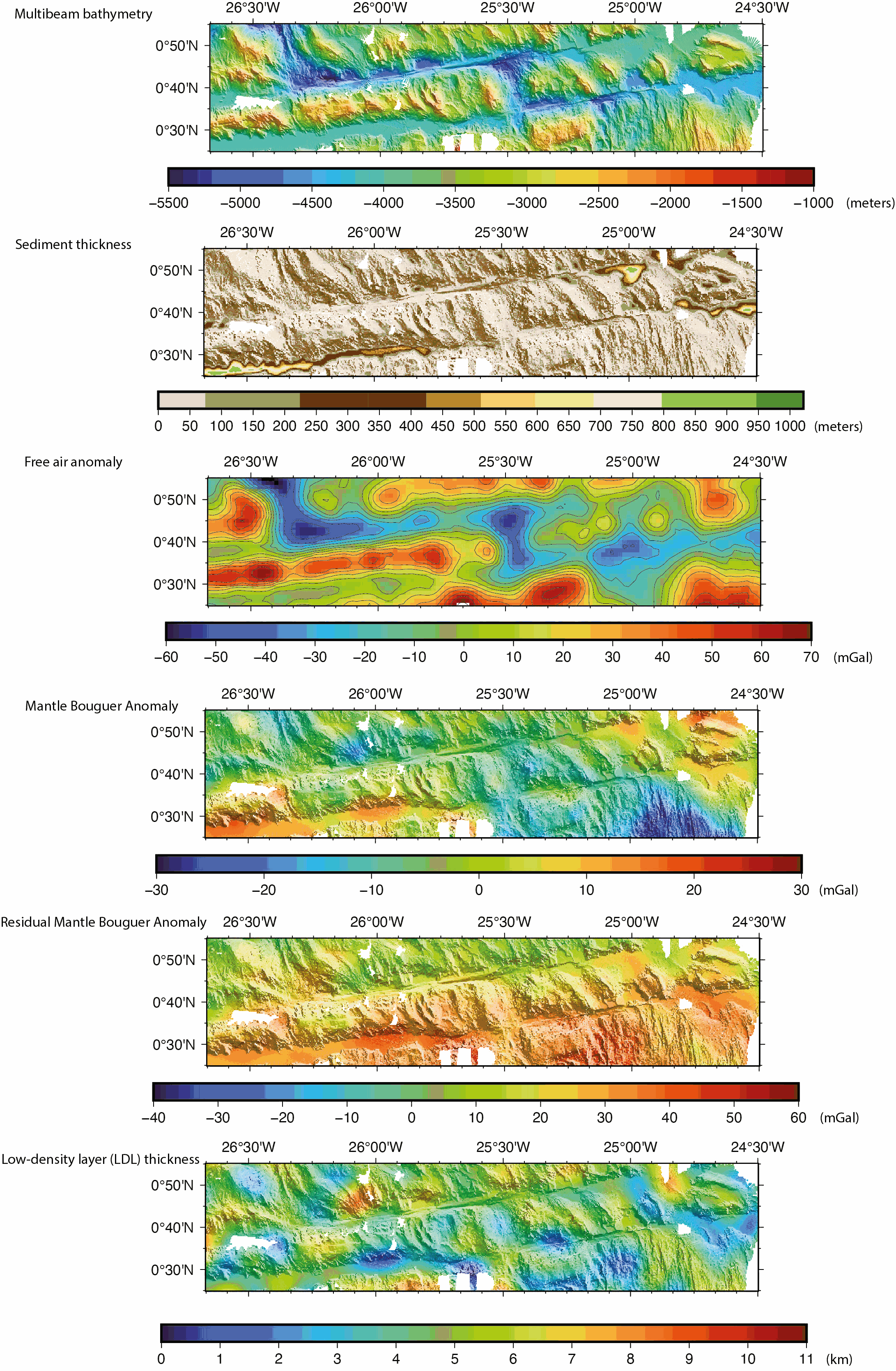
Gridded geophysical shipboard data on the South Intra-Transform segment of the St. Paul transform system (COLMEIA cruise)
Gridded shipboard multibeam bathymetry and gravity datasets acquired during the COLMEIA cruise (2013). Gridded sediment thickness derived from seismic data. Gridded crustal thickness computed from gravity. The gridded datasets cover the South intra-transform segment of the St. Paul transform fault system.
Grids created with the GMT software.
Grid details as follows:
Bathymetry: Grid file format: nf = GMT netCDF format (32-bit float), CF-1.7
x_min: -26.6678081446 x_max: -24.4991923884 x_inc: 0.000898349526186 name: longitude n_columns: 2415
y_min: 0.416125587833 y_max: 0.917145899441 y_inc: 0.000904368793517 name: latitude n_rows: 555
Sediment thickness: Grid file format: nf = GMT netCDF format (32-bit float), CF-1.7
x_min: -26.6697086826 x_max: -24.4984586826 x_inc: 0.00225 name: longitude n_columns: 966
y_min: 0.4154644221 y_max: 0.9194644221 y_inc: 0.00225 name: latitude n_rows: 225
Free air anomaly (merged shipboard and satellite data): Grid file format: nf = GMT netCDF format (32-bit float), CF-1.7
x_min: -26.6666666667 x_max: -24.5 x_inc: 0.0166666666667 (1 min) name: longitude n_columns: 131
y_min: 0.416666666667 y_max: 0.916666666667 y_inc: 0.0166666666667 (1 min) name: latitude n_rows: 31
Gravity anomalies (Mantle Bouguer, Residual Mantle Bouguer): Grid file format: nf = GMT netCDF format (32-bit float), CF-1.7
x_min: -26.6666666667 x_max: -24.5 x_inc: 0.00333333333333 (12 sec) name: longitude n_columns: 651
y_min: 0.416666666667 y_max: 0.916666666667 y_inc: 0.00333333333333 (12 sec) name: latitude n_rows: 151
Crustal thickness derived from the gravity anomalies: Grid file format: nf = GMT netCDF format (32-bit float), CF-1.7
x_min: -26.6666666667 x_max: -24.5 x_inc: 0.00333333333333 (12 sec) name: longitude n_columns: 651
y_min: 0.416666666667 y_max: 0.916666666667 y_inc: 0.00333333333333 (12 sec) name: latitude n_rows: 151
|
|
Citation proposal
MAIA Marcia (CNRS, Laboratoire Geo-Ocean UMR 6538 CNRS-IFREMER-UBO-UBS, F-29280, Plouzané, France) - VINCENT Clément (Univ. Bretagne Occidentale, Laboratoire Geo-Ocean UMR 6538 CNRS-IFREMER-UBO-UBS, F-29280, Plouzané, France) - BRIAIS Anne (CNRS, Laboratoire Geo-Ocean UMR 6538 CNRS-IFREMER-UBO-UBS, F-29280, Plouzané, France) - LIGI Marco (CNR, ISMAR, I-40129, Bologna, Italy) (2023) . Gridded geophysical shipboard data on the South Intra-Transform segment of the St. Paul transform system (COLMEIA cruise). https://services.mspdata.eu:/geonetwork/srv/api/records/seanoe:92690 |
Simple
- Date ( Publication )
- 2023
- Date ( Revision )
- 2023-07-25
- Other citation details
- Maia Marcia, Vincent Clément, Briais Anne, Ligi Marco (2023). Gridded geophysical shipboard data on the South Intra-Transform segment of the St. Paul transform system (COLMEIA cruise). SEANOE. https://doi.org/10.17882/92690
Author
Author
Publisher
- Keywords ( Theme )
-
- Mid-Oceanic Ridge , Transform faults , Mid-Atlantic Ridge , Saint Paul transform fault systm , Equatorial Atlantic , Multibeam bathymetry , Gravity anomaly , Crustal thickness , Marine geophysics , Tectonics , Detachment faults , Oceanic Core Complex , Oceanic lithosphere , Oceanic crust , Marine geology
- ODATIS aggregation parameters and Essential Variable names ( Theme )
-
- Bathymetry
- SeaDataNet Parameter Disciplines ( parameter )
-
- Marine geology
- Type de jeux de donnée ODATIS ( Theme )
-
- Observational data
- Use constraints
- Other restrictions
- Other constraints
- Date ( Publication )
- 2023
Publisher
Author
Author
Author
Author
Author
Author
- Association Type
- Cross reference
- Initiative Type
- document
- Association Type
- Cross reference
- Initiative Type
- Platform
- Metadata language
- English
- Topic category
-
- Oceans
))
- Distribution format
-
- GRD (GMT NETCDF) ( )
- OnLine resource
-
Processed data
NetCDF grid of the multibeam bathymetry (St. Paul transform fault system, South Intra-transform segment) - 3 MB
- OnLine resource
-
Processed data
Combined shipboard and satellite free air anomaly grid (St. Paul transform system South Intra-transform segment) - 17 KB
- OnLine resource
-
Processed data
Mantle Bouguer Anomaly (St. Paul transform fault system, South Intra-transform segment) - 261 KB
- OnLine resource
-
Processed data
Sediment thickness (St. Paul transform fault system, South Intra-transform segment) - 115 KB
- OnLine resource
-
Processed data
Residual Mantle Bouguer Anomaly (St. Paul transform fault system, South Intra-transform segment) - 243 KB
- OnLine resource
-
Processed data
Crustal (Low density layer) thickness (St. Paul transform fault system, South Intra-transform segment) - 267 KB
- OnLine resource
- DOI of the product
- OnLine resource
- Seanoe
- Hierarchy level
- Dataset
- Statement
-
Multibeam bathymetry acquired with NO L'Atalante Kongsberg EM122 echosounder.
Shipboard gravity data acquired with a Bodenseewerk KSS30 sensor.
Metadata
- File identifier
- seanoe:92690 XML
- Metadata language
- English
- Character set
- UTF8
- Hierarchy level
- Dataset
- Date stamp
- 2023-07-25
- Metadata standard name
- ISO 19115:2003/19139
- Metadata standard version
- 1.0