 Metadata catalogue
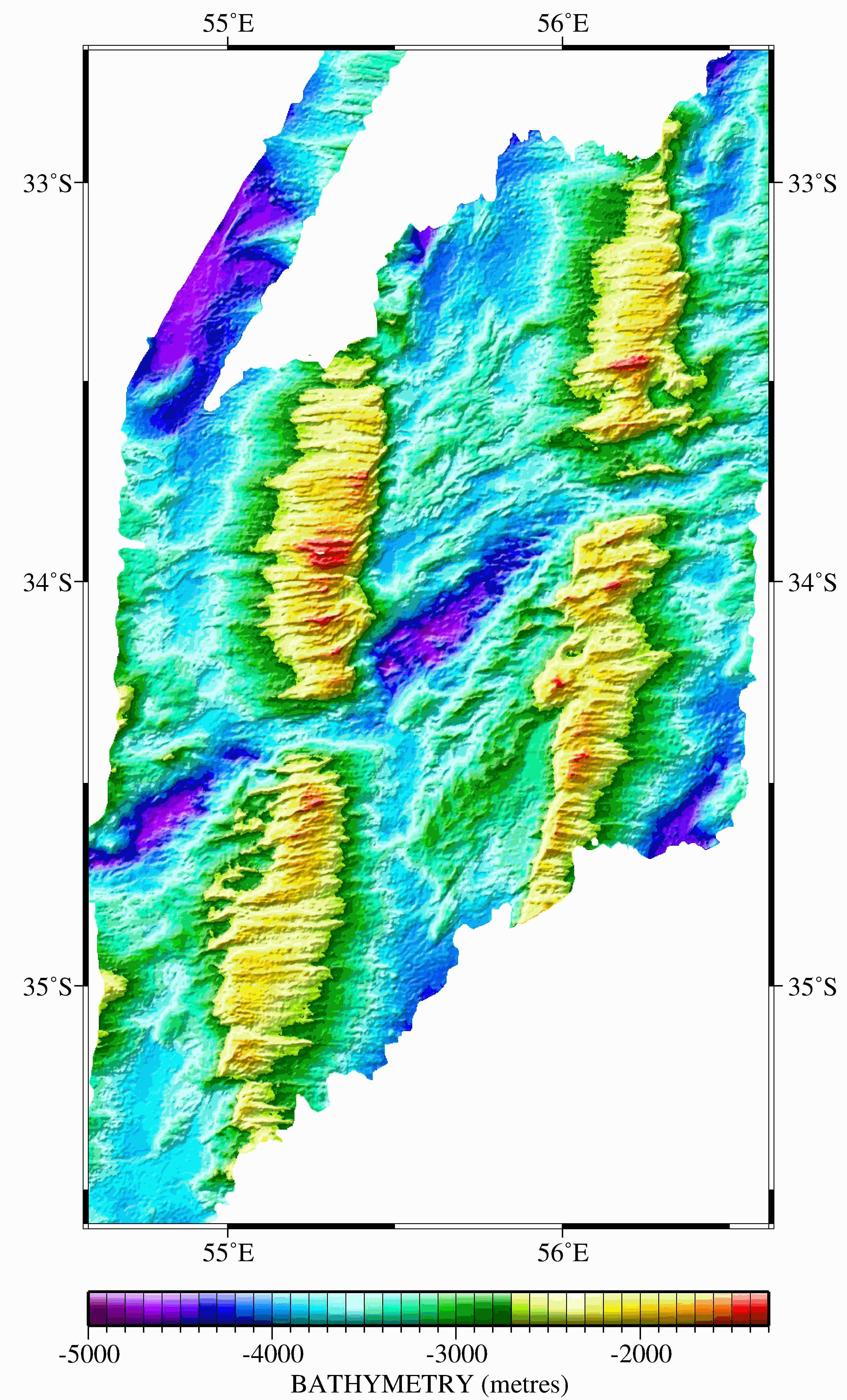
Gridded bathymetric data along the ultraslow spreading Southwest Indian Ridge between the Gallieni TF and the Rodrigues triple Junction
Six large grids were obtained by merging multibeam bathymetric data from several international cruises along the Southwest Indian Ridge from the Gallieni Transform Fault (54°E) to the Rodrigues Triple Junction (70°E). The spatial resolution is about 150 m. This dataset was used in several scientific papers.
|
|
Citation proposal
Sauter Daniel (Institut Terre et Environnement de Strasbourg ITES Université de Strasbourg CNRS UMR 7063 5 rue Descartes FR-67084 Strasbourg) - Cannat Mathilde (Université de Paris, Institut de Physique du Globe de Paris, UMR CNRS, Paris, France) (2022) . Gridded bathymetric data along the ultraslow spreading Southwest Indian Ridge between the Gallieni TF and the Rodrigues triple Junction. https://services.mspdata.eu:/geonetwork/srv/api/records/seanoe:90631 |
Simple
- Date ( Publication )
- 2022
- Date ( Revision )
- 2022-09-27
- Other citation details
-
Sauter Daniel, Cannat Mathilde (2022). Gridded bathymetric data along the ultraslow spreading Southwest Indian Ridge between the Gallieni TF and the Rodrigues triple Junction. SEANOE. https://doi.org/10.17882/906 31
In addition to properly cite this dataset, it would be appreciated that the following work(s) be cited too, when using this dataset in a publication :
Sauter Daniel, Sloan Heather, Cannat Mathilde, Goff John, Patriat Philippe, Schaming Marc, Roest Walter (2011). From slow to ultra-slow: How does spreading rate affect seafloor roughness and crustal thickness? GEOLOGY, 39(10), 911-914. https://doi.org/10.1130/G32028 .1
- Credit
-
We thank M. Maia, C. Hemond, and J. Dyment for providing unpublished data from the PLURIEL and GEISEIR cruises, and H. Kinoshita, S. Arai, T. Matsumoto, and H. Fujimoto, who agreed to provide YK98-08, KR00-06, YK01-14, and YK98-07 (Indoyo) cruise data to us. We also thank X. Morin and B. Ollivier of IPEV (Institut Polaire Français), R. Iwase of JAMSTEC (Japan Agency for Marine-Earth Science and Technology), and B. Loubrieu of Ifremer (Institut Français de Recherche Pour l’Exploitation de la Mer), who helped us to gather the data.
Publisher
- Keywords ( Theme )
-
-
Multibeam bathymetric data
,grids
,ultraslow spreading
,Southwest Indian Ridge
,Marine geology
-
- ODATIS aggregation parameters and Essential Variable names ( Theme )
-
- Bathymetry
- SeaDataNet Parameter Disciplines ( parameter )
-
- Marine geology
- Type de jeux de donnée ODATIS ( Theme )
-
- Aggregate data
- Use constraints
- Other restrictions
- Other constraints
-
This bathymetric grids are published without any warranty, express or implied. The user assumes all risk arising from his/her use of this data set. It is the sole responsibility of the user to assess if the data are appropriate for his/her use, and to interpret the data, data quality, and data accuracy accordingly.
- Date ( Publication )
- 2011
Publisher
Author
Author
Author
Author
Author
Author
Author
- Association Type
- Cross reference
- Initiative Type
- Study
- Date ( Publication )
- 2009
Publisher
Author
Author
Author
Author
Author
- Association Type
- Cross reference
- Initiative Type
- Study
- Date ( Publication )
- 2006
Publisher
Author
Author
Author
Author
Author
Author
Author
Author
- Association Type
- Cross reference
- Initiative Type
- Study
- Date ( Publication )
- 2004
Publisher
Author
Author
Author
Author
Author
Author
Author
- Association Type
- Cross reference
- Initiative Type
- Study
- Date ( Publication )
- 2003
Publisher
Author
Author
Author
Author
Author
Author
- Association Type
- Cross reference
- Initiative Type
- Study
- Association Type
- Cross reference
- Initiative Type
- Platform
- Association Type
- Cross reference
- Initiative Type
- Platform
- Association Type
- Cross reference
- Initiative Type
- Platform
- Association Type
- Cross reference
- Initiative Type
- Platform
- Association Type
- Cross reference
- Initiative Type
- Platform
- Association Type
- Cross reference
- Initiative Type
- Platform
- Association Type
- Cross reference
- Initiative Type
- Platform
- Association Type
- Cross reference
- Initiative Type
- Platform
- Association Type
- Cross reference
- Initiative Type
- Platform
- Association Type
- Cross reference
- Initiative Type
- Platform
- Association Type
- Cross reference
- Initiative Type
- Platform
- Metadata language
- English
- Topic category
-
- Oceans
))
- Distribution format
-
-
GRD (GMT NETCDF)
()
-
- OnLine resource
-
Processed data
grid of the SWIR section from Atlantis II TF to Novara TF - 87 MB
- OnLine resource
-
Processed data
grid of the SWIR section from Gallieni TF to Atlantis II TF - 87 MB
- OnLine resource
-
Processed data
grid of the SWIR section from Melville TF to 66°E - 87 MB
- OnLine resource
-
Processed data
grid of the SWIR section from Novara TF to Melville TF - 87 MB
- OnLine resource
-
Processed data
grid of the SWIR section from 68°E to the Rodrigues Triple Junction - 21 MB
- OnLine resource
-
Processed data
grid of the SWIR section from 62°30'E to 69°30'E - 102 MB
- OnLine resource
- DOI of the product
- OnLine resource
- Seanoe
- Hierarchy level
- Dataset
- Statement
-
The following Table is from the Sauter et al. 2011 Geology paper.
Metadata
- File identifier
- seanoe:90631 XML
- Metadata language
- English
- Character set
- UTF8
- Hierarchy level
- Dataset
- Date stamp
- 2022-09-27
- Metadata standard name
-
ISO 19115:2003/19139
- Metadata standard version
-
1.0
Overviews
Provided by
