Metadata catalogue
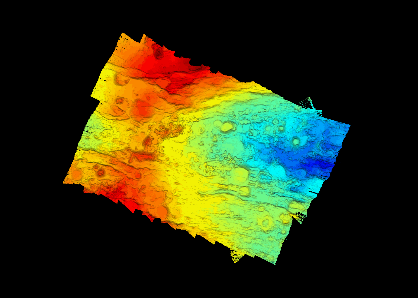
High-resolution bathymetry map (15-m grid) of a segment of the SWIR provided by MBES data acquired during the 2021 SWINGS marine expedition on the Marion Dufresne vessel
A MBES acoustic coverage of the PE-1 segment of the SWIR (South West Indian Ridge), more specifically in the vicinity of the dredge 5 location of the SWIFT cruise (2001), was carried out during the SWINGS cruise ( https://doi.org/10.17600/180019 25) with the French research vessel Marion Dufresne in 2021.
SWINGS data were acquired with the hull-mounted multibeam echosounder Kongsberg EM122 12 kHz using an optimised configuration for bathymetry data collection: vessel speed of 5 knots, dual swath, CW signal and an angular opening of 120°. Acoustic data were processed with GLOBE software ( https://doi.org/10.17882/70460 ) to provide a high-resolution bathymetry map (grid resolution of 15 m).
|
|
Citation proposal
JEANDEL catherine (CNRS-LEGOS, 31055 Toulouse) - PLANQUETTE Hélène (CNRS-LEMAR, 29280 Plouzané) - BRIAIS Anne (CNRS, GEO-OCEAN, 29280 Plouzané) - BOULART Cédric (CNRS, Station Biologique de Roscoff, France) - PONCELET Cyrille (IFREMER, GEO-OCEAN, 29280 Plouzané, France) - SCALABRIN Carla (IFREMER, Navire et Systèmes Embarqués, 29280 Plouzané, France) - BISQUAY Herve (GENAVIR, 29280 Plouzané) (2021) . High-resolution bathymetry map (15-m grid) of a segment of the SWIR provided by MBES data acquired during the 2021 SWINGS marine expedition on the Marion Dufresne vessel. https://services.mspdata.eu:/geonetwork/srv/api/records/seanoe:89462 |
Simple
- Date ( Publication )
- 2021-02-01
- Date ( Revision )
- 2024-06-06
- Other citation details
-
Jeandel Catherine, Planquette Hélène, Briais Anne, Boulart Cédric, Poncelet Cyrille, Scalabrin Carla, Bisquay Herve (2021). High-resolution bathymetry map (15-m grid) of a segment of the SWIR provided by MBES data acquired during the 2021 SWINGS marine expedition on the Marion Dufresne vessel. SEANOE. https://doi.org/10.17882/8946 2
Publisher
- Keywords ( Theme )
-
-
SWIR
,South West Indian Ridge
,acoustic coverage
,bathymetry
,MBES 12kHz
,Chemical oceanography
,Marine geology
-
- ODATIS aggregation parameters and Essential Variable names ( Theme )
-
- Bathymetry
- SeaDataNet Parameter Disciplines ( parameter )
-
- Chemical oceanography , Marine geology
- Type de jeux de donnée ODATIS ( Theme )
-
- /Observational data/in-situ
- Use constraints
- Other restrictions
- Other constraints
- Date ( Publication )
- 2024
Publisher
Author
Author
Author
Author
Author
Author
Author
Author
Author
Author
Author
Author
Author
Author
Author
Author
Author
Author
Author
- Association Type
- Cross reference
- Initiative Type
- Study
- Date ( Publication )
- 2023
Publisher
Author
Author
Author
Author
Author
Author
Author
Author
Author
Author
- Association Type
- Cross reference
- Initiative Type
- Study
- Date ( Publication )
- 2024
Publisher
Author
Author
Author
Author
Author
Author
Author
Author
- Association Type
- Cross reference
- Initiative Type
- dataset
- Association Type
- Cross reference
- Initiative Type
- Platform
- Metadata language
- English
- Topic category
-
- Oceans
))
- Distribution format
-
-
NC, NETCDF
() -
GEOTIFF
()
-
- OnLine resource
-
Processed data
Bathymetry map in netcdf4 format - 19 MB
- OnLine resource
-
Processed data
Bathymetry map elevation layer geotiff - 6 MB
- OnLine resource
-
Quality controlled data
Bathymetry map backscatter layer geotiff - 6 MB
- OnLine resource
- DOI of the product
- OnLine resource
- Seanoe
- Hierarchy level
- Dataset
- Statement
-
echosounder Kongsberg EM122 12 kHz
Metadata
- File identifier
- seanoe:89462 XML
- Metadata language
- English
- Character set
- UTF8
- Hierarchy level
- Dataset
- Date stamp
- 2024-06-06
- Metadata standard name
-
ISO 19115:2003/19139
- Metadata standard version
-
1.0