 Metadata catalogue
SeaExplorer glider SEA028 observations North of Svalbard in September 2017
The SeaExplorer glider Sea028 was deployed from the research vessel R/V Lance on the 15 September 2017 at 79.5°N, 8.6°E, on the western slope of Svalbard. The glider was recovered on 23 September 2017 at 80.62°N, 13.83°E.The glider was equipped with a GPCTD (Glider Payload Conductivity Temperature Depth from SeaBird), a dissolved oxygen sensor (Sea Bird SBE43F), and an optical sensor measuring Chlorophyll a (470/695 nm), Colored Dissolved Organic Matter (CDOM, 370/460 nm), and the total particle concentration or backscatter (backscattering at 700 nm) (EcoPuck from Wetlabs). The dataset is composed of the data corrected from the thermal lag and the sensor lag, despiked and interpolated every 1m. The profiles are separated.
|
|
Citation proposal
Koenig Zoe (Norwegian Polar Institute, Fram Centre, Tromsø, Norway Geophysical Institute and Bjerknes Center for Climate Research, University of Bergen, Bergen, Norway Laboratoire LOCEAN-IPSL, Sorbonne Universites (UPMC, Univ. Paris 6)-CNRS-IRD-MNHN, Paris, France) - Beguery Laurent (Alseamar, Rousset, France) - Provost Christine (Laboratoire LOCEAN-IPSL, Sorbonne Universites (UPMC, Univ. Paris 6)-CNRS-IRD-MNHN, Paris, France) - Meyer Amelie (University of Tasmania, Hobart, Australia) - Sundfjord Arild (Norwegian Polar Institute, Fram Centre, Tromsø, Norway) - Gascard Jean-Claude (Laboratoire LOCEAN-IPSL, Sorbonne Universites (UPMC, Univ. Paris 6)-CNRS-IRD-MNHN, Paris, France) (2017) . SeaExplorer glider SEA028 observations North of Svalbard in September 2017. https://services.mspdata.eu:/geonetwork/srv/api/records/seanoe:81755 |
Simple
- Date ( Publication )
- 2017-09
- Date ( Revision )
- 2022-06-13
- Other citation details
- Koenig Zoe, Beguery Laurent, Provost Christine, Meyer Amelie, Sundfjord Arild, Gascard Jean-Claude (2017). SeaExplorer glider SEA028 observations North of Svalbard in September 2017. SEANOE. https://doi.org/10.17882/81755
- Credit
- We thank ACCESS FP7 programme Grant 265863. We thank Norwegian Polar Institute and the captain and crew on board the R/V Lance for the logistics of the glider deployment and recovery. We also thank all the glider pilots from Alseamar
Publisher
- Keywords ( Theme )
-
- SeaExplorer glider , Svalbard Branch , Arctic Ocean , Svalbard , CTD , Optical sensor , Chlorophyll , CDOM , Yermak Plateau , Physical oceanography
- Keywords ( project )
-
- FP7 ACCESS (Agreement: 265863)
- ODATIS aggregation parameters and Essential Variable names ( Theme )
-
- Sea temperature , Dissolved oxygen , Dissolved Organic Matter , Suspended matter , Salinity , Pigments
- SeaDataNet Parameter Disciplines ( parameter )
-
- Physical oceanography
- Type de jeux de donnée ODATIS ( Theme )
-
- Analysis data
- Use constraints
- Other restrictions
- Other constraints
- Date ( Publication )
- 2022
Publisher
Author
Author
Author
Author
Author
Author
- Association Type
- Cross reference
- Initiative Type
- document
- Metadata language
- English
- Topic category
-
- Oceans
N
S
E
W
))
- Distribution format
-
- NC, NETCDF ( )
- OnLine resource
-
Processed data
SeaExplorer glider SEA028 observations North of Svalbard in September 2017 - 9 MB
- OnLine resource
- DOI of the product
- OnLine resource
- Seanoe
- Hierarchy level
- Dataset
- Statement
- The glider was equipped with a GPCTD (Glider Payload Conductivity Temperature Depth from SeaBird), a dissolved oxygen sensor (Sea Bird SBE43F), and an optical sensor measuring Chlorophyll a (470/695 nm), Colored Dissolved Organic Matter (CDOM, 370/460 nm), and the total particle concentration or backscatter (backscattering at 700 nm) (EcoPuck from Wetlabs).
Metadata
- File identifier
- seanoe:81755 XML
- Metadata language
- English
- Character set
- UTF8
- Hierarchy level
- Dataset
- Date stamp
- 2022-06-13
- Metadata standard name
- ISO 19115:2003/19139
- Metadata standard version
- 1.0
Overviews
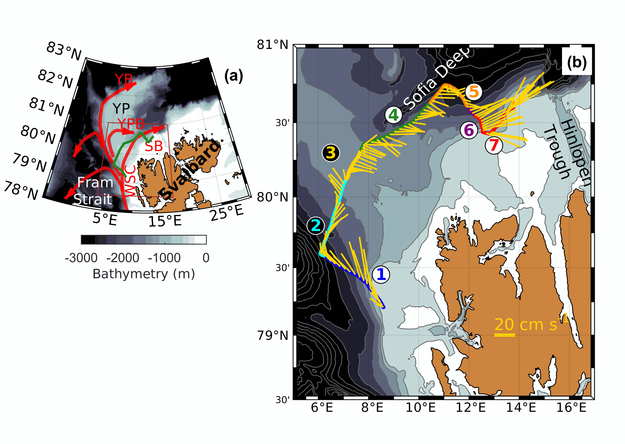
a) Atlantic Water path around the Yermak Plateau (YP). YB: Yermak Branch. YPB: Yermak Pass Branch. SB: Svalbard Branch. WSC: West Spitsbergen Current. The glider trajectory is indicated in green. b) In detail trajectory of the glider, with blue color at the beginning of the trajectory and red when the glider is picked up. Background is bathymetry from IBCAO-v3. Contours are bathymetry isolines every 200m. The yellow arrows are the depth-averaged current intensities deduced from the dead-reckoning data from the glider.
Provided by

Associated resources
Not available