Metadata catalogue
Raw data from a wide-angle seismic survey offshore French Guyana and Surinam
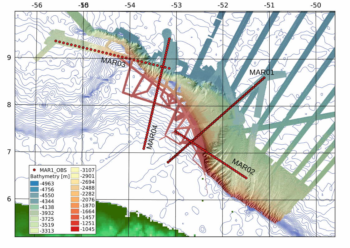
This archive includes wide-angle seismic data from profiles 1, 2, 3 and 2 of the MARGATS cruise offshore French Guyana and Surinam including navigation files. The objective is more precisely to characterize the crustal structure and evolution of marginal plateaux, sub-marine reliefs that are associated to 30 % of the transform margins in the world. These reliefs are systematically observed at the junction of different ages in relay zones between divergent and transform segments. Their building remains enigmatic although they represent reliefs established in geodynamical nubs that are keys ton understand the localisation of transform margins. This project MARGATS intend to image the deep structure of the marginal plateau (wide angle seismic and multichannel seismic MCS). The experimental site proposed is the Demerara plateau offshore French Guyana and Surinam and located at the junction between Central Atlantic locally opened in a divergent mode and Equatorial Atlantic opened mainly in transform mode in the area. Hence, this plateau has recorded at its different borders the divergent opening of the central Atlantic and the tranform opening of the Equatorial Atlantic. It may be this situation itself that leads to the formation of the plateau, but it requires to precisely constraint its deep internal structure. Finally the Demerara plateau is one of the more studied with petroleum seismic data and high resolution seismic data. It is then one of the ideal place to conduct a high resolution wide-angle deep seismic survey.
|
|
Citation proposal
KLINGELHOEFER Frauke (Ifremer, Geosciences Marines, ZI de la Pointe de Diable, 29280 Plouzané) - ROEST Walter (Ifremer, Geosciences Marines, ZI de la Pointe de Diable, 29280 Plouzané) - GRAINDORGE David (UMR6538, Domaines Océaniques, European Institute for Marine, Université) (2021) . Raw data from a wide-angle seismic survey offshore French Guyana and Surinam. https://services.mspdata.eu:/geonetwork/srv/api/records/seanoe:79396 |
Simple
- Date ( Publication )
- 2021-08-30
- Date ( Revision )
- 2022-10-10
- Other citation details
-
Klingelhoefer Frauke, Roest Walter, Graindorge David (2021). Raw data from a wide-angle seismic survey offshore French Guyana and Surinam. SEANOE. https://doi.org/10.17882/79396
In addition to properly cite this dataset, it would be appreciated that the following work(s) be cited too, when using this dataset in a publication :
Museur Thomas, Graindorge David, Klingelhoefer Frauke, Roest Walter, Basile C., Loncke L., Sapin F. (2021). Deep structure of the Demerara Plateau: From a volcanic margin to a Transform Marginal Plateau. Tectonophysics, 803, 228645 (22p.). https://doi.org/10.1016/j.tecto.2020.22864 5
- Credit
-
We would like to thank the captain and the crew of R/V L'Atalante as well as the technical team of Genavir and Ifremer for their help in data acquisition during the MARGATS cruise. We also acknowledge Région Bretagne and Ifremer for funding the PhD scholarship associated with this cruise.
Author
Publisher
- Keywords ( Theme )
-
-
Demerara Plateau
,Wide-angle seismic data
,french Guyana and Surinam
,Marine geology
-
- ODATIS aggregation parameters and Essential Variable names ( Theme )
-
- Bathymetry , Seismic
- SeaDataNet Parameter Disciplines ( parameter )
-
- Marine geology
- Type de jeux de donnée ODATIS ( Theme )
-
- /Observational data/in-situ
- Use constraints
- Other restrictions
- Other constraints
-
Although all data in this archive have been used by the authors, no warranty, expressed or implied, is made as to the accuracy of the data and/or related materials.
- Date ( Publication )
- 2022
Publisher
Author
Author
Author
Author
Author
Author
Author
Author
Author
Author
- Association Type
- Cross reference
- Initiative Type
- Study
- Date ( Publication )
- 2021
Publisher
Author
Author
Author
Author
Author
Author
Author
- Association Type
- Cross reference
- Initiative Type
- Study
- Association Type
- Cross reference
- Initiative Type
- Platform
- Metadata language
- English
- Topic category
-
- Oceans
))
- Distribution format
-
-
TEXTE
() -
SEGY
() -
SEGGY
()
-
- OnLine resource
-
Processed data
obs locations of the profile MAR 01 - 3 KB
- OnLine resource
-
Processed data
obs locations of the profile MAR 02 - 1 KB
- OnLine resource
-
Processed data
Shotfile for the MARGATS profile 01 - 108 KB
- OnLine resource
-
Processed data
Shotfile for the MARGATS profile 02 - 227 KB
- OnLine resource
-
Raw data
MAR01 - 10 GB
- OnLine resource
-
Raw data
MAR02 - 16 GB
- OnLine resource
-
Raw data
MAR03 - 15 GB
- OnLine resource
-
Raw data
MAR04 - 11 GB
- OnLine resource
- DOI of the product
- OnLine resource
- Seanoe
- Hierarchy level
- Dataset
- Statement
-
The ocean bottom seismometers (OBS) have been developed by Ifremer (French Research Institute for Exploitation of the Sea). For the first time, the acquisition and release electronics have been integrated to decrease the size, weight and cost of the equipment. Downloading of data by USB cable and recharging of batteries is accomplished from the outside allowing redeployment of the equipment without opening the glass sphere.
Auffret, Y., Pelleau, P., Klingelhoefer, F., Geli, L., Crozon, J., Lin, J. Y., & Sibuet, J. C. (2004). MicrOBS: A new generation of ocean bottom seismometer. First Break, 22(7).
Metadata
- File identifier
- seanoe:79396 XML
- Metadata language
- English
- Character set
- UTF8
- Hierarchy level
- Dataset
- Date stamp
- 2022-10-10
- Metadata standard name
-
ISO 19115:2003/19139
- Metadata standard version
-
1.0