 Metadata catalogue
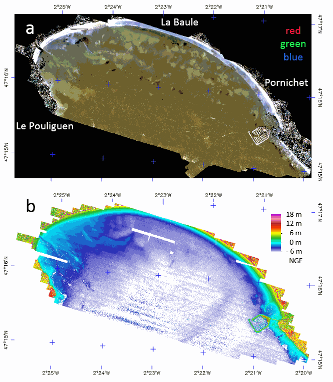
Full-waveform LiDAR bathymetry of the La Baule bay
The LiDAR used is the Titan DW 600 from Teledyne Optech of the “Platform topo-bathymétrique aéroportée Nantes-Rennes”. Both 532-nm and 1064-nm LiDAR swath were acquired 6th and 7th of October 2017, at 400 m above ground with a FOV of 28° giving strip image width of 199.5 m with a nominal footprint of 0.49 m along-track and 0.29 m cross-track. A mirror compensation and a sidelap of 30% was used to prevent empty space between strips. The effective incident angle range was from 4 to 20°. The aircraft speed being 201.7 km/h the down track footprint rise up to 0.98 m on sideway what justify a final spatial resolution of 1 m. The laser pulse frequency was set to 50 kHz (100 kHz locally) giving an overall mean point density of 3.52 points/m². The full-waveform (FWF) was recorded only in 532-nm with a maximum length of 60 m, at 1 GHz frequency, resulting in a vertical resolution of 0.15 m. The Optech LiDAR Mapping Suite (LMS) combines a Global Positioning System (GPS) and Inertial Measurement Unit (IMU) to provide a georeferenced point cloud and associated FWF with strip optimization. To compute the complete point cloud, LMS uses an analogous approach to photogrammetric block adjustment. On overlap areas between each flight line, planes (typically roofs in land) are extracted and used in a least squares adjustment model provided by LMS. The trajectory accuracy provided by GEOFIT Company was better than 0.15 m in planimetry and 0.08 m on elevation.
The set of data is stored in a zip file composed of the following image files associated with ENVI headers which are text files describing the image format.
- LaBaule_2017106-7-orthophoto: contain the mosaic of RGB image acquired with the camera associated to the LiDAR.
- LaBaule_2017106-7_536nm_raytracing-incident_angles_2m: contains the effective incident angle of each pixel retained in the mosaic with a pixel FOV of 0.3° and with a tilling of image strips in the top of each other from the North to the South.
- LaBaule_2017106-7_1064nm_raytracing_discrete_echo_ranges_2m: contains the elevation of the water surface of each pixel.
- LaBaule_2017106-7_536nm_raytracing_FWF_2m: contains the row FWF projected on the image plane at 0 m NGF with an offset of 30 m for easy spectral processing of the FWF (true range are stored in band names).
- LaBaule_2017106-7_536nm_raytracing_FWF_2m_intensity_stats: contains the basic statistics of the FWF intensities.
- LaBaule_2017106-7_536nm_raytracing_FWF_2m_range_stats: contains the min, max and thickness of the FWF ranges.
- LaBaule_2017106-7_536nm_raytracing_FWF_2m_row_results: contains the row results of water surface and method 1 (dddNCFWF echoes) and method 2 (NCFWFT-1 bottoms) bathymetries as defined in https://doi.org/10.3390/rs11020117.
- LaBaule_2017106-7_536nm_raytracing_FWF_4m_final_bathymetry: contains the final (cleaned NCFWFT-1 bottoms) bathymetry.
The same data were acquired the 11th of August 2018 during a low tide with the same settings without RGB camera but with a new FWF recorder giving a lot less noisy signal allowing a constant spatial resolution of 1 m. The set of data is stored in a zip file composed of the following image files associated with ENVI headers which are text files describing the image format.
- LaBaule_20180811_536nm_raytracing-incident_angles_1m: contains now 3 channels for the effective incident angle, the strip number and the GPS time.
- LaBaule_20180811_1064nm_raytracing_discrete_echo_ranges_1m: contains the elevation of the water surface and all echoes above it in each pixel.
- LaBaule_20180811_536nm_raytracing_FWF_1m: contains the row FWF projected on the image plane at 0 m NGF with an offset of 30 m for easy spectral processing of the FWF (true range are stored in band names).
- LaBaule_20180811_536nm_raytracing_FWF_1m_intensity_stats: contains the basic statistics of the FWF intensities.
- LaBaule_20180811_536nm_raytracing_FWF_1m_range_stats: contains the min, max and thickness of the FWF ranges.
- LaBaule_20180811_536nm_raytracing_FWF_1m_row_results: contains the row results of water surface and method 1 (dddNCFWF echoes) and method 2 (NCFWFT-1 bottoms) bathymetries as defined in https://doi.org/10.3390/rs11020117.
- LaBaule_20180811_536nm_raytracing_FWF_1m_final_bathymetry: contains the best of dddNCFWF echoes and NCFWFT-1 bottoms simply presented with the application of a 5x5 median filter.
-
|
|
Citation proposal
Launeau Patrick (Laboratoire de Planétologie et Géodynamique, UMR CNRS 6112, Université de Nantes, 2 rue de la Houssinière, 44322 Nantes, France) - Giraud Manuel (Laboratoire de Planétologie et Géodynamique, UMR CNRS 6112, Université de Nantes, 2 rue de la Houssinière, 44322 Nantes, France) - Robin Marc (Littoral Environnement Télédétection Géomatique, UMR CNRS 6554, Université de Nantes, Campus Tertre, 44312 Nantes, France) - Baltzer Agnes (Littoral Environnement Télédétection Géomatique, UMR CNRS 6554, Université de Nantes, Campus Tertre, 44312 Nantes, France) (2019) . Full-waveform LiDAR bathymetry of the La Baule bay. https://services.mspdata.eu:/geonetwork/srv/api/records/seanoe:58968 |
Simple
- Date ( Publication )
- 2019-04
- Date ( Revision )
- 2021-05-12
- Other citation details
-
Launeau Patrick, Giraud Manuel, Robin Marc, Baltzer Agnes (2019). Full-waveform LiDAR bathymetry of the La Baule bay. SEANOE. https://doi.org/10.17882/58968
In addition to properly cite this dataset, it would be appreciated that the following work(s) be cited too, when using this dataset in a publication :
Launeau Patrick, Giraud Manuel, Robin Marc, Baltzer Agnes (2019). Full-Waveform LiDAR Fast Analysis of a Moderately Turbid Bay in Western France. Remote Sensing, 11(2), 117 (23p.). https://doi.org/10.3390/rs11020117
Publisher
- Keywords ( Theme )
-
- Physical oceanography
- ODATIS aggregation parameters and Essential Variable names ( Theme )
-
- Bathymetry
- SeaDataNet Parameter Disciplines ( parameter )
-
- Physical oceanography
- Type de jeux de donnée ODATIS ( Theme )
-
- Observational data
- Use constraints
- Other restrictions
- Other constraints
- Date ( Publication )
- 2019
Publisher
Author
Author
Author
Author
- Association Type
- Cross reference
- Initiative Type
- document
- Metadata language
- English
- Topic category
-
- Oceans
))
- Distribution format
-
- ENVI ( )
- OnLine resource
-
Processed data
2019 version (1m resolution) - 1 GB
- OnLine resource
-
Processed data
2018 version (2-4m resolution) - 474 MB
- OnLine resource
- DOI of the product
- OnLine resource
- Seanoe
- Hierarchy level
- Dataset
- Statement
Metadata
- File identifier
- seanoe:58968 XML
- Metadata language
- English
- Character set
- UTF8
- Hierarchy level
- Dataset
- Date stamp
- 2021-05-12
- Metadata standard name
- ISO 19115:2003/19139
- Metadata standard version
- 1.0
Overviews
Provided by
