 Metadata catalogue
Processed AsterX AUV data from the Sea of Marmara: high-resolution bathymetry and seafloor backscatter images
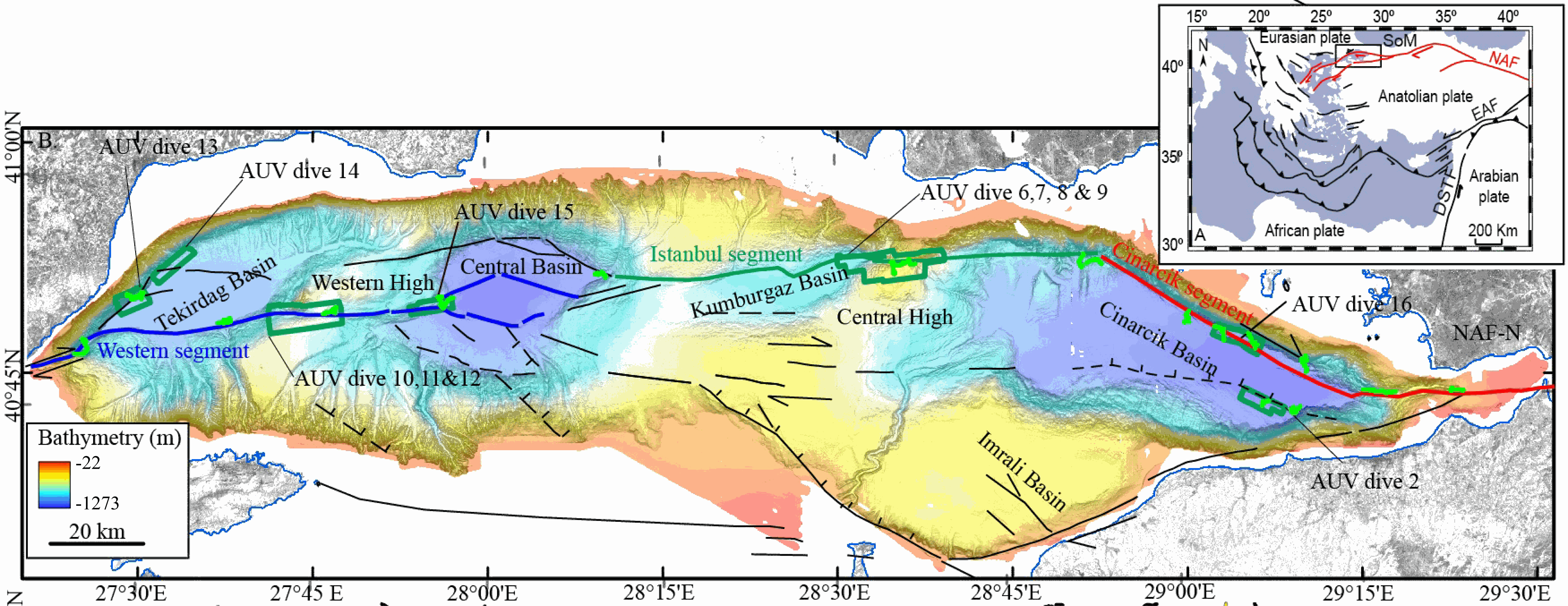
This data set contains processed multibeam sounder data from 12 dives of AsterX AUV performed on active faults scarps of the North Anatolian Fault system in the Sea of Marmara during the Marmesonet cruise (2009). The AUV carried a SIMRAD EM2000 multibeam echosounder, operating at 200 kHz, and surveyed at 50 to 70 m altitude, allowing a swath width of 150-200 m. Digital Elevation Models (DEM, in meters below sealevel) and seafloor backscatter intensity mosaics (relative amplitude in dB) are provided for 7 zones: Tekirdağ Basin W (dive 13), Tekirdağ Basin NW (dive 14), Western High (dives 10, 11 and 12), Western High E (dive 15), Central High (dive 6,7,8 and 9), Çınarcık Basin N (dive 16), Çınarcık Basin S (dive 2) (see figure). The horizontal resolution and grid pixel size of the DEM is 2 m. That of the backscatter intensity image is 1 m. Two versions of the DEM are provided. Version 1 is consistent with the backscatter image. Version 2 was updated applying a Fofonoff correction to the depths and relocating part of the AUV multibeam sounding points to fit EM302 shipborne multibeam maps. Version 2 depths and absolute positions are more accurate (10 m in the WGS-84 reference frame), but Version 1 will give better results if the backscatter image is applied as a texture or shading on the DEM. DEM and Backscatter raster files are provided in GeoTIFF format (readable with ArcGis 10.3 and QGIS 3) and use projected cartesian coordinates. They were converted from CARAIBES (Ifremer bathymetry and imagery processing software) output raster files with QGIS using GDAL translator. The Coordinate Reference System is a world Mercator projection based on WGS-84 datum, using meter units and a standard parallel at N40° latitude (latitude of preserved scale) {proj4: +proj=merc +lon_0=0 +lat_ts=+40 +x_0=0 +y_0=0 +datum=WGS84 +units=m +no_defs}. For GIS skeptics, one possible way to use these grids with Generic Mapping Tools is to perform a reverse projection back to geographic coordinates. Assuming the default PROJ_ELLIPSOID is properly set to WGS-84, the reverse projection can be applied (using gmt version 5) with the following command line:
gmt grdproject AUV_XXX.tif=gd -GAUV_XXX.grd -Jm0/40/1:1 -F -C -I -V
|
|
Citation proposal
GRALL Celine (Aix Marseille Univ, CNRS, IRD, INRA, Coll France, CEREGE, Aix-en-Provence, France Ifremer, Centre de Bretagne, Marine Geoscience Unit, Plouzané, France) - DUPRE Stephanie (Ifremer, Centre de Bretagne, Marine Geoscience Unit, Plouzané, France) - GUERIN Charline (Ifremer, Centre de Bretagne, Marine Geoscience Unit, Plouzané, France) - NORMAND Alain (Ifremer, Centre de Bretagne, Marine Geoscience Unit, Plouzané, France) - GAILLOT Arnaud (Ifremer, Centre de Bretagne, Marine Geoscience Unit, Plouzané, France) - Fleury Jules (Aix Marseille Univ, CNRS, IRD, INRA, Coll France, CEREGE, Aix-en-Provence, France) - Henry Pierre (Aix Marseille Univ, CNRS, IRD, INRA, Coll France, CEREGE, Aix-en-Provence, France) (2018) . Processed AsterX AUV data from the Sea of Marmara: high-resolution bathymetry and seafloor backscatter images. https://services.mspdata.eu:/geonetwork/srv/api/records/seanoe:55744 |
Simple
- Date ( Publication )
- 2018-07
- Date ( Revision )
- 2021-05-12
- Other citation details
-
Grall Celine, Dupre Stephanie, Guerin Charline, Normand Alain, Gaillot Arnaud, Fleury Jules, Henry Pierre (2018). Processed AsterX AUV data from the Sea of Marmara: high-resolution bathymetry and seafloor backscatter images. SEANOE. https://doi.org/10.17882/55744
In addition to properly cite this dataset, it would be appreciated that the following work(s) be cited too, when using this dataset in a publication :
Grall Celine, Henry Pierre, Dupre Stephanie, Geli Louis, Scalabrin Carla, Zitter Tiphaine A. C., Sengor A. M. Celal, Cagatay M. Namik, Cifci Gunay (2018). Upward migration of gas in an active tectonic basin: an example from the Sea of Marmara. Deep-sea Research Part Ii-topical Studies In Oceanography, 153, 17-35. https://doi.org/10.1016/j.dsr2.2018.06.007
- Credit
-
Genavir AsterX team (Xavier Placaud, Olivier Fauvin, Yann Houard) operated the AsterX AUV. Cruise logistics and post-cruise work were in part funded by European Network of Excellence ESONET (FP6 contract N° 036851) through demonstration mission MARMESONET, and by CNRS/INSU support fund for oceanographic cruises.
Author
Author
Publisher
- Keywords ( Theme )
-
-
Marine geology
-
- ODATIS aggregation parameters and Essential Variable names ( Theme )
-
- Bathymetry
- SeaDataNet Parameter Disciplines ( parameter )
-
- Marine geology
- Type de jeux de donnée ODATIS ( Theme )
-
- /Observational data/in-situ
- Use constraints
- Other restrictions
- Other constraints
-
Data are published without any warranty, express or implied. The user assumes all risk arising from his/her use of data. Data are intended to be research-quality and include estimates of data quality and accuracy, but it is possible that these estimates or the data themselves contain errors. It is the sole responsibility of the user to assess if the data are appropriate for his/her use, and to interpret the data, data quality, and data accuracy accordingly. Authors welcome users to ask questions and report problems.
- Date ( Publication )
- 2021
Publisher
Author
Author
Author
Author
Author
- Association Type
- Cross reference
- Initiative Type
- Study
- Date ( Publication )
- 2020
Publisher
Author
Author
Author
Author
Author
Author
Author
- Association Type
- Cross reference
- Initiative Type
- Study
- Date ( Publication )
- 2019
Publisher
Author
- Association Type
- Cross reference
- Initiative Type
- Study
- Date ( Publication )
- 2018
Publisher
Author
Author
Author
Author
Author
Author
Author
Author
Author
- Association Type
- Cross reference
- Initiative Type
- Study
- Date ( Publication )
- 2021
Publisher
Author
Author
Author
Author
Author
- Association Type
- Cross reference
- Initiative Type
- dataset
- Date ( Publication )
- 2019
Publisher
Author
Author
Author
Author
- Association Type
- Cross reference
- Initiative Type
- dataset
- Association Type
- Cross reference
- Initiative Type
- Platform
- Metadata language
- English
- Topic category
-
- Oceans
))
- Distribution format
-
-
TIFF
()
-
- OnLine resource
- Quality controlled data
- OnLine resource
- DOI of the product
- OnLine resource
- Seanoe
- Hierarchy level
- Dataset
- Statement
Metadata
- File identifier
- seanoe:55744 XML
- Metadata language
- English
- Character set
- UTF8
- Hierarchy level
- Dataset
- Date stamp
- 2021-05-12
- Metadata standard name
-
ISO 19115:2003/19139
- Metadata standard version
-
1.0
Overviews
Provided by
