 Metadata catalogue
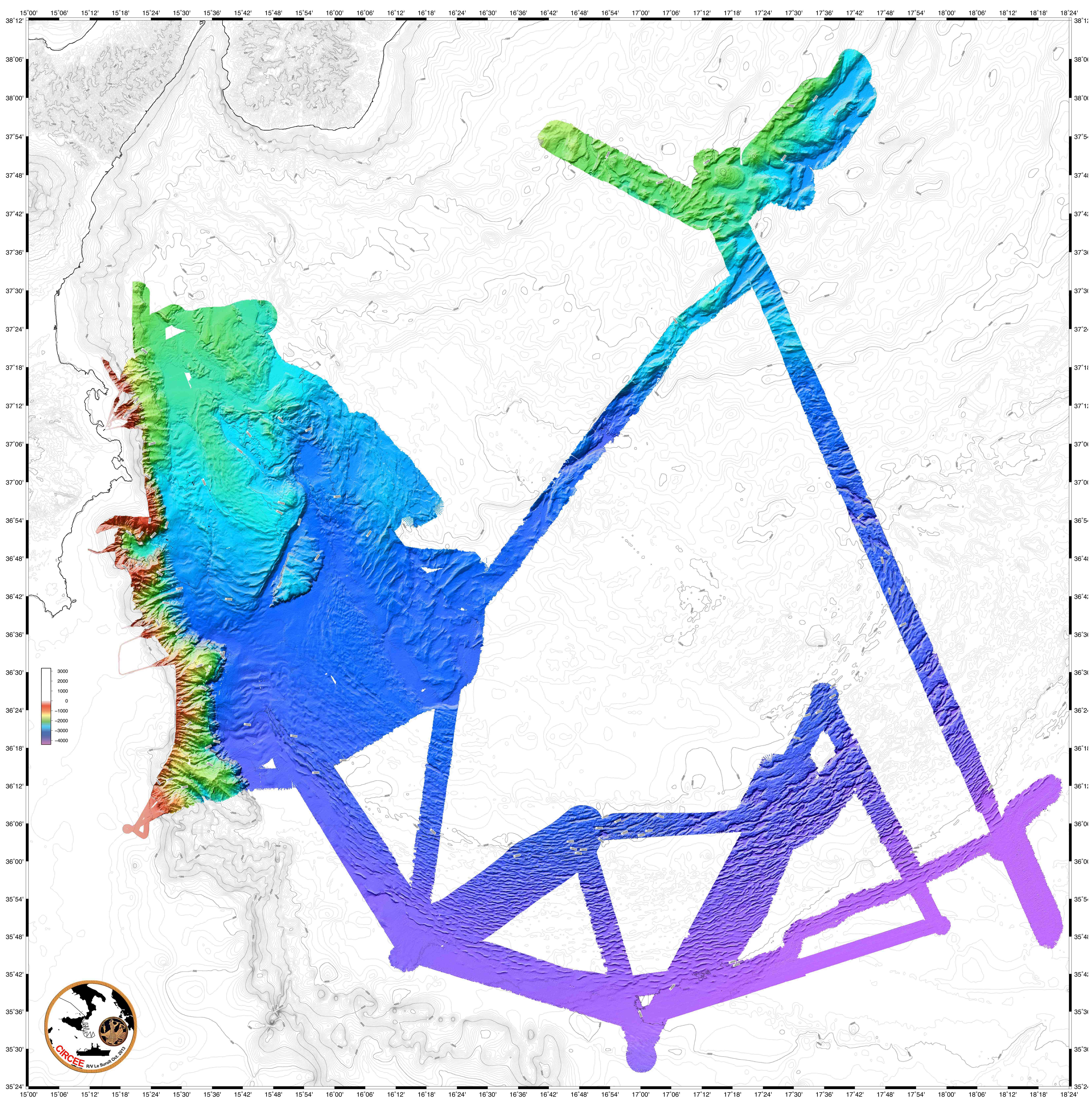
Circee marine geophysical survey: Ionian Sea (Eastern Sicily - Calabria)
The following data were acquired in 2013 by the french research vessel N/O Suroit during the CIRCEE cruise (see the cruise report):
- High-resolution 72-trace seismic data. The files are available in the segy format. A map is provided to locate the 1500 km of seismic profile acquired.
- Gridded bathymetry data (resolution : 90m) available in GRD format (software GMT Generic Mapping Software de Wessel & Smith based on NetCDF libraries). A map is available.
- Bathymetry data from multibeam echo sounder Kongsberg-Simrad EM302. The data are available in the raw data mbg and include the travel time and amplitude (reflectivity).
- Highfrequency chirp-sonar data. The files are available in the segy format. A map is available in the cruise report.
|
|
Citation proposal
Gutscher M.A (Domaines Océaniques, Université de Brest/CNRS, IUEM, Plouzané, France) - Mercier de Lepinay B (GeoAzur, Université de Nice/CNRS, Sophia-Antipolis, Valbonne, France) - Pinheiro L (Department of Geosciences and CESAM, University of Aveiro, Aveiro, Portugal) - LeFaou Y (Service Hydrographique et Océanographique de la Marine, Brest, France) - GALLAIS F (Domaines Océaniques, Université de Brest/CNRS, IUEM, Plouzané, France Ifremer, Institut Carnot Géosciences Marines, Ifremer EDROME Géosciences Marines, Plouzané, France) - Dominguez S (Geosciences Montpellier, University of Montpellier II/CNRS, Montpellier, France) - Babonneau N (Domaines Océaniques, Université de Brest/CNRS, IUEM, Plouzané, France) - Barreca G (Department of Biology, Geology and Environmental Science, University of Catania, Catania, Italy) - Micallef A (Department of Geosciences, University of Malta, Msida, Malta, 9Institute for Marine Sciences/CNR via Gobetti, Bologna, Italy) - San Pedro L (Domaines Océaniques, Université de Brest/CNRS, IUEM, Plouzané, France) (2013) . Circee marine geophysical survey: Ionian Sea (Eastern Sicily - Calabria). https://services.mspdata.eu:/geonetwork/srv/api/records/seanoe:49652 |
Simple
- Date ( Publication )
- 2013
- Date ( Revision )
- 2025-04-16
- Other citation details
- Gutscher M.A, Mercier De Lepinay B, Pinheiro L, Lefaou Y, Gallais F, Dominguez S, Babonneau N, Barreca G, Micallef A, San Pedro L (2013). Circee marine geophysical survey: Ionian Sea (Eastern Sicily - Calabria). SEANOE. https://doi.org/10.17882/49652
Author
Publisher
- Keywords ( Theme )
-
- Marine geology
- Keywords ( project )
-
- FP7 ASTARTE (Agreement: 603839)
- ODATIS aggregation parameters and Essential Variable names ( Theme )
-
- Bathymetry , Seismic
- SeaDataNet Parameter Disciplines ( parameter )
-
- Marine geology
- Research Infrastructure ( Theme )
-
- IR-FOF
- Type de jeux de donnée ODATIS ( Theme )
-
- /Observational data/in-situ
- Use constraints
- Other restrictions
- Other constraints
- Date ( Publication )
- 2023
Publisher
Author
Author
Author
Author
Author
Author
- Association Type
- Cross reference
- Initiative Type
- Study
- Date ( Publication )
- 2021
Publisher
Author
Author
Author
Author
Author
- Association Type
- Cross reference
- Initiative Type
- Study
- Date ( Publication )
- 2017
Publisher
Author
Author
Author
Author
Author
Author
Author
Author
Author
Author
Author
Author
Author
Author
Author
Author
- Association Type
- Cross reference
- Initiative Type
- Study
- Date ( Publication )
- 2016
Publisher
Author
Author
Author
Author
Author
Author
Author
Author
Author
Author
Author
- Association Type
- Cross reference
- Initiative Type
- Study
- Association Type
- Cross reference
- Initiative Type
- Platform
- Metadata language
- English
- Topic category
-
- Oceans
))
- Distribution format
-
- SEGY ( )
- PDF ( )
- GRD ( )
- IMAGE ( )
- MBG ( )
- OnLine resource
-
Quality controlled data
High-resolution 72-trace seismic data [RESTRICTED] - 4 GB
- OnLine resource
-
High-resolution 72-trace seismic map - 3 MB
High-resolution 72-trace seismic map - 3 MB
- OnLine resource
-
Quality controlled data
Gridded bathymetry data [RESTRICTED] - 164 MB
- OnLine resource
-
Gridded bathymetry map - 2 MB
Gridded bathymetry map - 2 MB
- OnLine resource
-
Raw data
Bathymetry data from multibeam echo sounder Kongsberg-Simrad EM302 [RESTRICTED] - 1 GB
- OnLine resource
-
Quality controlled data
Highfrequency chirp-sonar data [RESTRICTED] - 1 GB
- OnLine resource
- Cruise report
- OnLine resource
- DOI of the product
- OnLine resource
- Seanoe
- Hierarchy level
- Dataset
- Statement
Metadata
- File identifier
- seanoe:49652 XML
- Metadata language
- English
- Character set
- UTF8
- Hierarchy level
- Dataset
- Date stamp
- 2025-04-16
- Metadata standard name
- ISO 19115:2003/19139
- Metadata standard version
- 1.0

