 Metadata catalogue
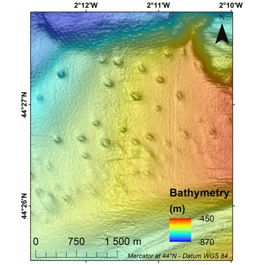
Pockmark morphological attributes at the Aquitaine slope, GAZCOGNE1 (2013) and BOBGEO2 (2010) marine expeditions
Pockmarks are defined as depressions on the seabed and are usually formed by fluid expulsions. Recently discovered, pockmarks along the Aquitaine slope within the French EEZ, were manually mapped although two semi-automated methods were tested without convincing results. In order to potentially highlight different groups and possibly discriminate the nature of the fluids involved in their formation and evolution, a morphological study was conducted, mainly based on multibeam data and in particular bathymetry from the marine expedition GAZCOGNE1, 2013. Bathymetry and seafloor backscatter data, covering more than 3200 km², were acquired with the Kongsberg EM302 ship-borne multibeam echosounder of the R/V Le Suroît at a speed of ~8 knots, operated at a frequency of 30 kHz and calibrated with ©Sippican shots. Precision of seafloor backscatter amplitude is +/- 1 dB. Multibeam data, processed using Caraibes (©IFREMER), were gridded at 15x15 m and down to 10x10 m cells, for bathymetry and seafloor backscatter, respectively. The present table includes 11 morphological attributes extracted from a Geographical Information System project (Mercator 44°N conserved latitude in WGS84 Datum) and additional parameters related to seafloor backscatter amplitudes. Pockmark occurrence with regards to the different morphological domains is derived from a morphological analysis manually performed and based on GAZCOGNE1 and BOBGEO2 bathymetric datasets.
The pockmark area and its perimeter were calculated with the “Calculate Geometry” tool of Arcmap 10.2 (©ESRI) ( https://desktop.arcgis.com/en/arcmap/10.3/manage-data/tables/calculating-area-length-and-other-geometric-properties.htm ). A first method to calculate pockmark internal depth developed by Gafeira et al. was tested (Gafeira J, Long D, Diaz-Doce D (2012) Semi-automated characterisation of seabed pockmarks in the central North Sea. Near Surface Geophysics 10 (4):303-315, doi:10.3997/1873-0604.2012018). This method is based on the “Fill” function from the Hydrology toolset in Spatial Analyst Toolbox Arcmap 10.2 (©ESRI), ( https://pro.arcgis.com/en/pro-app/tool-reference/spatial-analyst/fill.htm ) which fills the closed depressions. The difference between filled bathymetry and initial bathymetry produces a raster grid only highlighting filled depressions. Thus, only the maximum filling values which correspond to the internal depths at the apex of the pockmark were extracted. For the second method, the internal pockmark depth was calculated with the difference between minimum and maximum bathymetry within the pockmark.
Latitude and longitude of the pockmark centroid, minor and major axis lengths and major axis direction of the pockmarks were calculated inside each depression with the “Zonal Geometry as Table” tool from Spatial Analyst Toolbox in ArcGIS 10.2 (©ESRI) ( https://pro.arcgis.com/en/pro-app/tool-reference/spatial-analyst/zonal-statistics.htm ). Pockmark elongation was calculated as the ratio between the major and minor axis length.
Cell count is the number of cells used inside each pockmark to calculate statistics ( https://pro.arcgis.com/en/pro-app/tool-reference/spatial-analyst/zonal-geometry.htm ). Cell count and minimum, maximum and mean bathymetry, slope and seafloor backscatter values were calculated within each pockmark with “Zonal Statistics as Table” tool from Spatial Analyst Toolbox in ArcGIS 10.2 (©ESRI). Slope was calculated from bathymetry with “Slope” function from Spatial Analyst Toolbox in ArcGIS 10.2 (©ESRI) and preserves its 15 m grid size ( https://pro.arcgis.com/en/pro-app/tool-reference/spatial-analyst/slope.htm ). Seafloor backscatter amplitudes (minimum, maximum and mean values) of the surrounding sediments were calculated within a 100 m buffer around the pockmark rim.
|
|
Citation proposal
MICHEL Guillaume (IFREMER, Unité Géosciences Marines, France) - DUPRE Stephanie (IFREMER, Unité Géosciences Marines, France) - SAOUT Johan (IFREMER, Unité Géosciences Marines, France) - EHRHOLD Axel (IFREMER, Unité Géosciences Marines, France) - GUERIN Charline (IFREMER, Unité Géosciences Marines, France) - GAUTIER Emeric (IFREMER, Unité Géosciences Marines, France) - BRETON Cecile (E.C.C.O, Maison-Alfort, France) - BOURILLET Jean-Francois (IFREMER, Unité Géosciences Marines, France) - LOUBRIEU Benoit (IFREMER, Unité Géosciences Marines, France) (2017) . Pockmark morphological attributes at the Aquitaine slope, GAZCOGNE1 (2013) and BOBGEO2 (2010) marine expeditions. https://services.mspdata.eu:/geonetwork/srv/api/records/seanoe:48323 |
Simple
- Date ( Publication )
- 2017-02-16
- Date ( Revision )
- 2021-05-12
- Other citation details
-
Michel Guillaume, Dupre Stephanie, Saout Johan, Ehrhold Axel, Guerin Charline, Gautier Emeric, Breton Cecile, Bourillet Jean-Francois, Loubrieu Benoit (2017). Pockmark morphological attributes at the Aquitaine slope, GAZCOGNE1 (2013) and BOBGEO2 (2010) marine expeditions. SEANOE. https://doi.org/10.17882/48 323
- Credit
-
The GAZCOGNE study as well as the marine expedition GAZCOGNE1 were co-funded by TOTAL and IFREMER as part of the PAMELA (Passive Margin Exploration Laboratories) scientific project ( http://dx.doi.org/10.18142/236 ). The BOBGEO2 marine expedition was part of the FP7 EU Project CORALFISH.
Publisher
- Keywords ( Theme )
-
-
pockmark
,morphology
,seafloor
,bathymetry
,backscatter
,GIS
,Marine geology
,Physical oceanography
-
- Keywords ( project )
-
-
FP7 CORALFISH (Agreement: 213144)
-
- ODATIS aggregation parameters and Essential Variable names ( Theme )
-
- Bathymetry
- SeaDataNet Parameter Disciplines ( parameter )
-
- Marine geology , Physical oceanography
- Type de jeux de donnée ODATIS ( Theme )
-
- Analysis data
- Use constraints
- Other restrictions
- Other constraints
- Date ( Publication )
- 2017
Publisher
Author
Author
Author
Author
Author
Author
Author
Author
Author
Author
Author
Author
- Association Type
- Cross reference
- Initiative Type
- Study
- Association Type
- Cross reference
- Initiative Type
- Platform
- Association Type
- Cross reference
- Initiative Type
- Platform
- Metadata language
- English
- Topic category
-
- Oceans
))
- Distribution format
-
-
CSV
()
-
- OnLine resource
- Quality controlled data
- OnLine resource
- DOI of the product
- OnLine resource
- Seanoe
- Hierarchy level
- Dataset
- Statement
Metadata
- File identifier
- seanoe:48323 XML
- Metadata language
- English
- Character set
- UTF8
- Hierarchy level
- Dataset
- Date stamp
- 2021-05-12
- Metadata standard name
-
ISO 19115:2003/19139
- Metadata standard version
-
1.0
Point of contact
Overviews
Provided by
