 Metadata catalogue
Multibeam bathymetry and VHR seismic data acquired on the Lansdowne Bank, New Caledonia (SW Pacific)
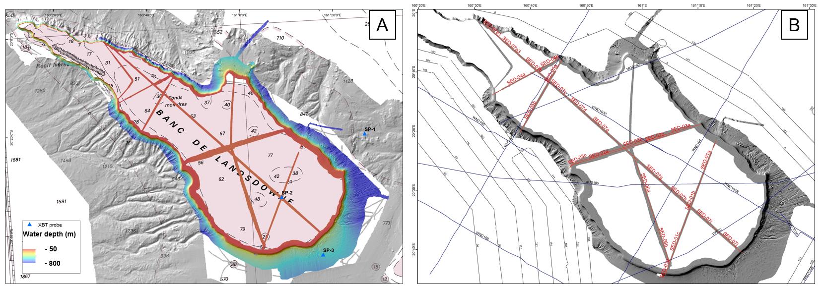
This dataset comprises multibeam bathymetry and very high resolution seismic data acquired over the Lansdowne Bank (New Caledonia, SW Pacific), during the SEDLAB cruise. The latter was a 29 day research cruise on the French national fleet ship R/V ALIS that took place in April and May 2018. The main aim was to characterise the sedimentary dynamics and the stratigraphic architecture of the Lansdowne Bank, a partly drowned, isolated rimmed carbonate platform of around 4000 km2 located offshore New Caledonia in the SW Pacific. More than 2000 km2 of new multibeam data, 7 single-channel SPARKER seismic profiles, along with 15 rock dredges and 8 sediment gravity cores were acquired on the bank top and adjacent slopes. These data reveal that the bank is typified by an almost continuous 4 km wide reef rim located in ca. 50 m water depth, showing typical “spurs and grooves” patterns. This outer rim surrounds a paleolagoon that gently deepens towards the inner platform, reaching up to 100 m water depth. Pinnacle reefs, up to 20 m high, are common close to the external reef rim, but are also scattered within the inner platform. Surprisingly, no obvious transfer axes across the reef rims, internal channels, tidal shoals or any clear current-related bedforms were imaged on the bank top. The bank is bordered by very steep slopes showing numerous bypass features such as canyons, channels and gullies. Additionally, spectacular bank margin collapses were identified. They are evidenced by up to 10 km wide intraslope and bank edge failure scarps, resulting in a scalloped geometry of the bank margin. Scarps are associated with km-sized blocks at the base-of-slope. Integration of all surface and subsurface data, together with post-cruise sedimentological, biostratigraphic and radiometric analyses on rock and sediment samples will hopefully bring new insight into the onset, aggradation and drowning history of the platform in relation to past sea-level changes and vertical tectonic movements. We believe that such results are relevant for the understanding of carbonate slope processes as well as platform-to-basin sediment budgets.
|
|
Citation proposal
Etienne Samuel (Service de la Géologie de Nouvelle-Calédonie (DIMENC) ADECAL Technopole) - Collot Julien (Service de la Géologie de Nouvelle-Calédonie (DIMENC)) - Le Roy Pascal (Université de Bretagne Occidentale) - Tournadour Elsa (Service de la Géologie de Nouvelle-Calédonie (DIMENC) ADECAL Technopole IFREMER) - ROEST Walter (IFREMER) - PATRIAT Martin (IFREMER) - Largeau Maria (Intechmer) - Clerc Camille (Université de la Nouvelle-Calédonie) - Dechnick Belinda (University of Sydney) - Sanborn Kelsey (University of Sydney) - Lepareur Fanny (Museum National d'Histoire Naturelle) - Horowitz Jeremy (James Cook University) - Jorry Stephan (Université de Bretagne Occidentale) - Webster Jody (University of Sydney) (2025) . Multibeam bathymetry and VHR seismic data acquired on the Lansdowne Bank, New Caledonia (SW Pacific). https://services.mspdata.eu:/geonetwork/srv/api/records/seanoe:105903 |
Simple
- Date ( Publication )
- 2025-04-11
- Date ( Revision )
- 2025-06-04
- Other citation details
-
Etienne Samuel, Collot Julien, Le Roy Pascal, Tournadour Elsa, Roest Walter, Patriat Martin, Largeau Maria, Clerc Camille, Dechnick Belinda, Sanborn Kelsey, Lepareur Fanny, Horowitz Jeremy, Jorry Stephan, Webster Jody (2025). Multibeam bathymetry and VHR seismic data acquired on the Lansdowne Bank, New Caledonia (SW Pacific). SEANOE. https://doi.org/10.17882/10590 3
Author
Author
Author
Author
- Keywords ( Theme )
-
-
New Caledonia
,Isolated carbonate platforms
,Submarine slopes
,MTCs
,Multibeam bathymetry
,Seismic reflection
,Marine geology
-
- ODATIS aggregation parameters and Essential Variable names ( Theme )
-
- Bathymetry , Seismic
- SeaDataNet Parameter Disciplines ( parameter )
-
- Marine geology
- Type de jeux de donnée ODATIS ( Theme )
-
- /Observational data/in-situ
- Use limitation
- Use constraints
- Other restrictions
- Other constraints
- Date ( Publication )
- 2021
Publisher
Author
Author
Author
Author
Author
Author
Author
Author
Author
Author
Author
Author
Author
Author
Author
Author
- Association Type
- Cross reference
- Initiative Type
- Study
- Date ( Publication )
- Association Type
- Cross reference
- Initiative Type
- Study
- Association Type
- Cross reference
- Initiative Type
- Platform
- Metadata language
- English
- Topic category
-
- Oceans
))
- Distribution format
-
-
GEOTIFF
() -
SEG
()
-
- OnLine resource
-
Processed data
SEBLAB_bathymetry_30m_WGS84 - 6 MB
- OnLine resource
-
Quality controlled data
SEDLAB_processed_seismic_SEG - 732 MB
- OnLine resource
- DOI of the product
- OnLine resource
- Seanoe
- Hierarchy level
- Dataset
- Statement
Metadata
- File identifier
- seanoe:105903 XML
- Metadata language
- English
- Character set
- UTF8
- Hierarchy level
- Dataset
- Date stamp
- 2025-06-04
- Metadata standard name
-
ISO 19115:2003/19139
- Metadata standard version
-
1.0
Point of contact
Point of contact
Overviews
Provided by
