Metadata catalogue
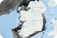
INFOMAR Backscatter
INFOMAR backscatter data is measured primarily by multibeam (MBES) and also singlebeam (SBES) echosounder devices. MBES transducers transmit multiple a high frequency pulses of sound from beneath a vessel in a fan shape down to the seabed.
The amount of energy reflected back to the vessel for each pulse of sound is termed the backscatter. The amount of energy returned will depend on the seabed type, for example a softer bottom such as mud will return a weaker signal than a harder bottom, like rock. Backscatter therefore can be used to infer seabed type.
|
|
Citation proposal
Geological Survey Ireland (2017) . INFOMAR Backscatter. Marine Institute https://services.mspdata.eu:/geonetwork/srv/api/records/ie.marine.data:dataset.860 |
Simple
- Alternate title
- Backscatter data from INFOMAR Survey
- Date ( Publication )
- 2017-11-09
- Date ( Revision )
- 2019-11-20
- Date ( Creation )
- 2000-01-01
- Identifier
- ie.marine.data:dataset.860
- Identifier
- {"@context":"http://schema.org","@type":"Dataset","name":"INFOMAR Backscatter","description":"INFOMAR backscatter data is measured primarily by multibeam (MBES) and also singlebeam(SBES) echosounder devices. MBES transducers transmit multiple a high frequency pulses of sound from beneath a vessel in a fan shape down to the seabed. The amount of energy reflected back to the vessel for each pulse of sound is termed the backscatter. The amount of energy returned will depend on the seabed type, for example a softer bottom such as mud will return a weaker signal than a harder bottom, like rock. Backscatter therefore can be used to infer seabed type.","url": "https://data.marine.ie/dataset/860","temporalCoverage": "2000-01-01T00:00:00/9999-12-31","keywords":["",""],"variablesMeasured":["Date (time from 00:00 01/01/1760 to 00:00 UT on day)","Latitude north","Longitude east"],"creator":{"@type":"Organization","url":"http://www.gsi.ie/","name": "Geological Survey Ireland"},"license": ["CC-By 4.0"],"spatialCoverage":{"@type": "Place","geo" : { "@type": "GeoShape", "polygon": "46.83333347,-25.000816176 46.83333347,-5.27233311 57.366661531,-5.27233311 57.366661531,-25.000816176 46.83333347,-25.000816176"}},"distribution": [{"@type": "DataDownload","encodingFormat":"GeoTIFF","contentUrl": "http://www.infomar.ie"}]}
- Credit
- Geological Survey Ireland
Author
- Website
-
Geological Survey Ireland home page
Geological Survey Ireland home page
Publisher
- Maintenance and update frequency
- As needed
- BODC Parameter Usage Vocabulary
-
- Date (time from 00:00 01/01/1760 to 00:00 UT on day) , Latitude north , Longitude east
- SeaDataNet Parameter Discovery Vocabulary
-
- Horizontal spatial co-ordinates , Date and time
- SeaDataNet Agreed Parameter Groups
-
- Administration and dimensions
- International Standards Organisation ISO19115 Topic Categories
-
- location
- SeaDataNet Parameter Disciplines ( parameter )
-
- Administration and dimensions
- GEMET - INSPIRE themes, version 1.0 ( Theme )
-
- Geographical grid systems
- BODC parameter semantic model sphere names
-
- not applicable
- BODC parameter semantic model matrices
-
- not applicable
- Marine Institute Calendar Concept Scheme ( Temporal )
-
- January , February , March , April , May , June , July , August , September , October , November , December , January , February , March , April , May , June , July , August , September , October , November , December , January , February , March , April , May , June , July , August , September , October , November , December , January , February , March , April , May , June , July , August , September , October , November , December , January , February , March , April , May , June , July , August , September , October , November , December , January , February , March , April , May , June , July , August , September , October , November , December , January , February , March , April , May , June , July , August , September , October , November , December , January , February , March , April , May , June , July , August , September , October , November , December , January , February , March , April , May , June , July , August , September , October , November , December , January , February , March , April , May , June , July , August , September , October , November , December , January , February , March , April , May , June , July , August , September , October , November , December , January , February , March , April , May , June , July , August , September , October , November , December , January , February , March , April , May , June , July , August , September , October , November , December , January , February , March , April , May , June , July , August , September , October , November , December , January , February , March , April , May , June , July , August , September , October , November , December , January , February , March , April , May , June , July , August , September , October , November , December , January , February , March , April , May , June , July , August , September , October , November , December , January , February , March , April , May , June , July , August , September , October , November , December , January , February , March , April , May , June , July , August , September , October , November , December , January , February , March , April , May , June , July , August , September , October , November , December , January , February , March , April , May , June , July , August , September , October , November , December
- MEDIN metadata record availability ( service )
-
- Marine Environmental Data and Information Network
- OGC Simple Feature Types
-
- Polygon
- Marine Institute Dataset Communities
-
- Dataset
- Mission Atlantic - Resources ( Theme )
-
- Data
- Mission Atlantic - Case Studies ( Theme )
-
- Celtic Seas
- Mission Atlantic - Work Package ( Theme )
-
- WP4 Benthic Mapping
- Mission Atlantic - BODC Parameters ( Theme )
-
- /Marine geology/Gravity, magnetics and bathymetry
- Mission Atlantic - Data type (DMP) ( Theme )
-
- Acoustic data
- Use limitation
- Consult license for use limitations
- Use limitation
- CC-BY 4.0
- Access constraints
- Other restrictions
- Aggregate Datasetindentifier
- ie.marine.data:dataset.855
- Association Type
- Cross reference
- Initiative Type
- Mission
- Aggregate Datasetindentifier
- ie.marine.data:dataset.912
- Association Type
- Cross reference
- Initiative Type
- Mission
- Aggregate Datasetindentifier
- ie.marine.data:dataset.965
- Association Type
- Cross reference
- Initiative Type
- Mission
- Aggregate Datasetindentifier
- ie.marine.data:dataset.1422
- Association Type
- Cross reference
- Initiative Type
- Mission
- Aggregate Datasetindentifier
- ie.marine.data:dataset.886
- Association Type
- Cross reference
- Initiative Type
- Mission
- Aggregate Datasetindentifier
- ie.marine.data:dataset.932
- Association Type
- Cross reference
- Initiative Type
- Mission
- Aggregate Datasetindentifier
- ie.marine.data:dataset.936
- Association Type
- Cross reference
- Initiative Type
- Mission
- Aggregate Datasetindentifier
- ie.marine.data:dataset.1024
- Association Type
- Cross reference
- Initiative Type
- Mission
- Aggregate Datasetindentifier
- ie.marine.data:dataset.1030
- Association Type
- Cross reference
- Initiative Type
- Mission
- Aggregate Datasetindentifier
- ie.marine.data:dataset.1473
- Association Type
- Cross reference
- Initiative Type
- Mission
- Aggregate Datasetindentifier
- ie.marine.data:dataset.1572
- Association Type
- Cross reference
- Initiative Type
- Mission
- Aggregate Datasetindentifier
- ie.marine.data:dataset.1581
- Association Type
- Cross reference
- Initiative Type
- Mission
- Aggregate Datasetindentifier
- ie.marine.data:dataset.1592
- Association Type
- Cross reference
- Initiative Type
- Mission
- Aggregate Datasetindentifier
- ie.marine.data:dataset.1609
- Association Type
- Cross reference
- Initiative Type
- Mission
- Aggregate Datasetindentifier
- ie.marine.data:dataset.1855
- Association Type
- Cross reference
- Initiative Type
- Mission
- Aggregate Datasetindentifier
- ie.marine.data:dataset.1907
- Association Type
- Cross reference
- Initiative Type
- Mission
- Aggregate Datasetindentifier
- ie.marine.data:dataset.1928
- Association Type
- Cross reference
- Initiative Type
- Mission
- Aggregate Datasetindentifier
- ie.marine.data:dataset.1948
- Association Type
- Cross reference
- Initiative Type
- Mission
- Aggregate Datasetindentifier
- ie.marine.data:dataset.1965
- Association Type
- Cross reference
- Initiative Type
- Mission
- Aggregate Datasetindentifier
- ie.marine.data:dataset.2039
- Association Type
- Cross reference
- Initiative Type
- Mission
- Aggregate Datasetindentifier
- ie.marine.data:dataset.2050
- Association Type
- Cross reference
- Initiative Type
- Mission
- Aggregate Datasetindentifier
- ie.marine.data:dataset.2060
- Association Type
- Cross reference
- Initiative Type
- Mission
- Aggregate Datasetindentifier
- ie.marine.data:dataset.2084
- Association Type
- Cross reference
- Initiative Type
- Mission
- Aggregate Datasetindentifier
- ie.marine.data:dataset.2104
- Association Type
- Cross reference
- Initiative Type
- Mission
- Date ( adopted )
- 2006-01-01
Point of contact
- Website
-
INFOMAR home page
INFOMAR home page
Principal investigator
- Website
-
Geological Survey Ireland home page
Geological Survey Ireland home page
contributor
- Website
-
Marine Institute home page
Marine Institute home page
funder
- Website
-
Department of Communications, Climate Action and the Environment home page
Department of Communications, Climate Action and the Environment home page
- Other citation details
- The INtegrated Mapping FOr the Sustainable Development of Ireland’s MArine Resource (INFOMAR) programme is a joint venture between the Geological Survey Ireland and the Marine Institute. The programme is a successor to the Irish National Seabed Survey (INSS) and concentrates on creating a range of integrated mapping products of the physical, chemical and biological features of the seabed in the near-shore area.
- Association Type
- Larger work citation
- Initiative Type
- Project
- Spatial representation type
- Grid
- Metadata language
- English
- Topic category
-
- Location
))
- Extent type code
- true
- Reference system identifier
- INSPIRE RS registry / http://www.opengis.net/def/crs/EPSG/0/3857
- Distribution format
-
- GeoTIFF (0.01 )
- OnLine resource
-
GeoTIFF
GeoTIFF
- OnLine resource
-
Geological Survey Ireland home page
Geological Survey Ireland home page
- OnLine resource
-
INFOMAR home page
INFOMAR home page
- Hierarchy level
- Dataset
Conformance result
- Date ( Publication )
- 2010-12-08
- Explanation
- See the referenced specification
- Pass
- true
- Statement
- Data supplied by Geological Survey Ireland.
Metadata
- File identifier
- ie.marine.data:dataset.860 XML
- Metadata language
- English
- Hierarchy level
- Dataset
- Date stamp
- 2022-02-23T12:52:31.951Z
- Metadata standard name
- ISDI Metadata Profile
- Metadata standard version
- 1.2