Metadata catalogue
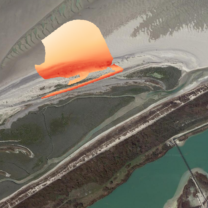
Topographic DEM - Littoral pebble spit - Baie de Somme
DATA :
Topographic DEMs obtained from a LIDAR system or a terrestrial laser scanner (TLS).
(1) LIDAR data :
Topographic DEM with a 1-m resolution and accuracy below 10 cm RMS in altimetry acquired by an airborne scanner (Leica ALS60).
(2) TLS data :
Topographic DEMs with a 10-cm resolution and an accuracy comprised between the mm and some cm (depending on the survey conditions). The DEM is derived from a point cloud obtained with a terrestrial laser scanner (Leica ScanStation C10).
AREA :
Portion of the littoral pebble spit of the Baie de Somme, in the sector of La Mollière (Cayeux-sur-Mer), including the upper part of the sandy intertidal zone and the active barrier spit, over 200 m in the cross-shore direction and 1200 m in the longshore direction.
|
|
Citation proposal
Sophie Le Bot (University of Rouen, UMR CNRS 6143 M2C) (2019) . Topographic DEM - Littoral pebble spit - Baie de Somme. SNO DYNALIT https://services.mspdata.eu:/geonetwork/srv/api/records/f75030db-31a7-477e-9430-65e8d929d335 |
Simple
- Date ( Creation )
- 2019-05-29
- Date ( Publication )
- 2019-05-29
- Identifier
-
DOI:10.12770/f75030db-31a7-477e-9430-65e8d929d335
- Credit
-
UMR 6143 M2C
Author
Pl. Emile Blondel, Bâtiment Blondel Nord
Mont Saint Aignan
76821
France
Publisher
- Keywords ( Theme )
-
-
SNO DYNALIT
,Topography
,TLS
,DTM
-
- Keywords ( Place )
-
-
France
,Hauts-de-France
,Somme
,Cayeux-sur-Mer
,Baie de Somme
-
- Thèmes Sextant Thèmes Sextant ( Theme )
-
-
/Physical Environment/Bathymetry/Digital Terrain Model
-
- GEMET - INSPIRE themes, version 1.0 GEMET - INSPIRE themes, version 1.0 ( Theme )
-
-
Elevation
-
- Thématiques - SIMM Thématiques - SIMM ( Theme )
-
- ,
- Sous-regions marines Sous-regions marines ( Place )
-
-
Channel-North Sea
-
- Type de jeux de donnée ODATIS Type de jeux de donnée ODATIS ( Theme )
-
-
Données d'observation
-
- Infrastructures de recherche Infrastructures de recherche ( Theme )
-
-
IR-ILICO
-
- Services Nationaux d'Observation Services Nationaux d'Observation ( Theme )
-
-
SNO-Dynalit
-
- ODATIS aggregation parameters and Essential Variable names ODATIS aggregation parameters and Essential Variable names ( Theme )
-
-
Trait de côte
-
- Use limitation
-
Données sous Licence ouverte / Open licence : http://www.etalab.gouv.fr/pages/licence-ouverte-open-licence-5899923.html
- Access constraints
- Other restrictions
- Use constraints
- License
- Other constraints
-
if there is DOI (Digital Object Identifier), respect the citation indicated in the Landing Page of the DOI (link specified in the metadata sheet).
- Spatial representation type
- grid Grid
- Distance
- 1 meter
- Metadata language
- English
- Character set
- utf8 UTF8
- Topic category
-
- Geoscientific information
- Oceans
- Elevation
))
- Reference system identifier
-
EPSG
/Lambert 93 (EPSG:2154)
/7.4
- Number of dimensions
- 0
- Cell geometry
- Area
- Transformation parameter availability
- false
- Distribution format
-
-
GeoTIFF
(1.0
)
-
- OnLine resource
- SNO DYNALIT
- OnLine resource
-
DOI of the dataset
DOI of the dataset
- OnLine resource
-
MNT_BaieDeSomme_2011-auj.
DEM - Baie de Somme - 2011-now (WMS-T)
- OnLine resource
-
MNT-Topo_BaieDeSomme_20190326
MNT (TLS) - Baie de Somme - 26/03/2019
- OnLine resource
-
MNT-Topo_BaiedeSomme_20190301
MNT - Baie-de-Somme - 01/03/2019 (CSV)
- OnLine resource
-
MNT-Topo_BaieDeSomme_20170407
MNT (TLS) - Baie de Somme - 07/04/2017
- OnLine resource
-
MNT-Topo_BaieDeSomme_20161216
MNT (Lidar topographique) - Baie de Somme - 16/12/2016 (File)
- OnLine resource
-
MNT-Topo_BaieDeSomme_20150615
MNT (Lidar topographique) - Baie de Somme - 15/06/2015
- OnLine resource
-
MNT-Topo_BaieDeSomme_20131104
MNT (Lidar topographique) - Baie de Somme - 04/11/2013
- OnLine resource
-
MNT-Topo_BaieDeSomme_20130401
MNT (Lidar topographique) - Baie de Somme - 01/04/2013
- OnLine resource
-
MNT-Topo_BaieDeSomme_20121118
MNT (Lidar topographique) - Baie de Somme - 18/11/2012
- OnLine resource
-
MNT-Topo_BaieDeSomme_20120602
MNT (Lidar topographique) - Baie de Somme - 02/06/2012
- OnLine resource
-
MNT-Topo_BaieDeSomme_20110928
MNT (Lidar topographique) - Baie de Somme - 28/09/2011
- Hierarchy level
- Dataset
Absolute external positional accuracy
Conformance result
- Date ( Creation )
- 2012-01-16
- Explanation
-
Not assessed
- Pass
- false
- Statement
-
Topographic DEM - Littoral pebble spit - Baie de Somme
AREA:
The DEM concerns a portion of the littoral pebble spit of the Baie de Somme, in the sector of La Mollière (Cayeux-sur-Mer), including the upper part of the sandy intertidal zone and the active barrier spit, over 200 m in the cross-shore direction and 1200 m in the longshore direction
RESOLUTION and ACCURACY:
(1) LIDAR:
Resolution : 1 m
Altrimetric Accuracy : under 10 cm RMS
(2) TLS:
Resolution of the DEM is 10-cm and precision is between the mm and some cm (depending on the survey conditions).
DATA ACQUISITION :
(1) LIDAR:
The DEM is derived from an airborne topographic LiDAR, Leica ALS60. Terrasolid software is used to generate a proper georeferenced point cloud using ground DEMs acquired by DGPS. The bare ground is then classified by automatic and manual extraction. The points are then averaged to create a DEM. The planimetric system used is Lambert 93 and the altimetric measurements are expressed in the IGN -69 system. For the full complex process details, see M2C laboratory.
Data acquisition and processing by Laurent Froideval
(2) TLS:
The DEM is derived from a point cloud obtained with a terrestrial laser scanner (Leica ScanStation C10, © Leica Geosystems). Several scanning positions are operated for each survey. The original data were acquired with a variable resolution, fixed at 10 cm at 100 m from the scanning positions. The data are processed using the Leica Cyclone software (© Leica Geosystems) for scanning points assembling and georeferencing. A manual clean-up of the data is necessary, in particular for the vegetation ; most of the vegetation has been removed when the vegetation density is low and allow to identify individuals. Georeferencing of the topographic data is realised using a DGPS (Leica Viva GS15, © Leica Geosystems). DGPS data are acquired during 1 to 2h at 2 different places during each survey, and are then postprocessed using Leica Geo Office software (© Leica Geosystems). Position is given in the projection Lambert 93 associated to the geodetic system RGF93. The position precision is between the mm and some cm depending on the survey conditions. These 2 places are specifically scanned with a very high resolution (scan windows), and then spotted in the point cloud. Their positions are filled in the Cyclone software (© Leica Geosystems), which calculates then the position of all the points in the cloud in the Lambert 93 projection.
The topographic data are then integrated in the ArcGIS software (© ESRI). Point data are converted into a raster with a 10-cm resolution (mean of the topographic information per 10-cm mesh), then converted into a point layer to be interpolated using kriging (Geostatistical Analyst Tool used with optimized model and parameters).
Data acquisition and processing by Sophie Le Bot
Metadata
- File identifier
- f75030db-31a7-477e-9430-65e8d929d335 XML
- Metadata language
- English
- Character set
- UTF8
- Hierarchy level
- Dataset
- Hierarchy level name
-
Série de données
- Date stamp
- 2025-05-16T09:37:00.78133Z
- Metadata standard name
-
ISO 19115-3 - SEXTANT ISO 19115-3 - SEXTANT
- Metadata standard version
-
1.0
Point of contact
Point of contact
Pl. Emile Blondel, Bâtiment Blondel Nord
Mont Saint Aignan
76821
France