 Metadata catalogue
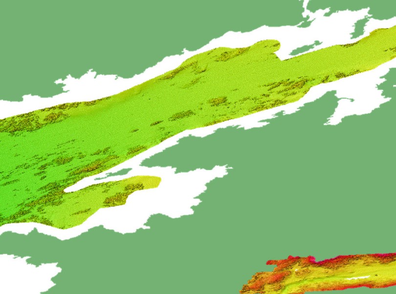
INSS INFOMAR Seabed Samples Particle Size Analysis
The INtegrated Mapping FOr the Sustainable Development of Ireland's MArine Resource (INFOMAR) programme is a joint venture between the Geological Survey of Ireland (GSI) and the Marine Institute (MI). The programme is the successor to the Irish National Seabed Survey (INSS) and concentrates on creating integrated mapping products related to the seabed.
INFOMAR Seabed Samples Particle Size Analysis represent locations where samples have been taken and particle size analysis (PSA) carried out on samples.
Sediment type classification based on percentage sand, mud and gravel (after Folk 1954).
Every sediment is a mixture of grains of varying sizes. It groups grains into mud, sand and gravel on the basis of their diameter. The relative proportion of the grains in the three categories is then used to describe the sediment and is displayed in a diagram commonly called a “Folk triangle”. This classification has 15 terms to describe the seabed sediments.
Samples from the seabed are taken by grab and box core sampling instruments.
PSA is applied to determine the range of sediment sizes contained in the sample which can often reveal an insight about the processes operating in the depositional environment. The results show percentage gravels, sands, silt and mud present in the sample. This analysis is also used to determine if the sample is well or poorly sorted.
|
|
Citation proposal
(2013) . INSS INFOMAR Seabed Samples Particle Size Analysis. https://services.mspdata.eu:/geonetwork/srv/api/records/f2607bfe-00d5-4b59-bdd0-920c09608900 |
Simple
- Alternate title
-
GE.GeologicCollection.IE.GeologicalSurveyIreland-MarineInstitute.INSS-INFOMAR.SampleParticleAnalysis.2000-2020
- Date ( Creation )
- 2000-01-01T00:00:00
- Date ( Publication )
- 2013-06-20T09:59:00
- Date ( Revision )
- 2021-02-19T09:58:00
- Identifier
-
INSPIRE UUID
/GE.GeologicCollection.IE.GeologicalSurveyIreland-MarineInstitute.INSS-INFOMAR.SampleParticleAnalysis.2000-2020
/1.0
- Purpose
-
Seabed mapping of the Irish marine resource.
- Status
- On going
Point of contact
Beggars Bush Barracks
Haddington Road
Dublin 4
D04 K7X4
Ireland
- Maintenance and update frequency
- Annually
- GemetInspireTheme ( Theme )
-
-
Geology
-
- GEMET - Concepts, version 4.1.2, 16 Aug 2018 ( Theme )
-
-
ocean, sea, sea bed, map, mapping, submarine morphology, monitoring technique, sampling, sampling technique, physical property, sediment,
-
- dbpedia.org ( Theme )
-
-
seafloor mapping, bathymetry, bathymetric survey, bathymetric surveying
-
- GEMET - Concepts, version 4.1.2, 16 Aug 2018 ( Discipline )
-
-
science, earth science, geology, marine geology, hydrography
-
- GeoNames 2012 November, Version 3.1 ( Place )
-
-
Ireland
-
- SeaDataNet sea areas ( Place )
-
-
Atlantic Ocean, North Atlantic Ocean, North East Atlantic Ocean (limit 40W), Celtic Sea, Irish Sea and St. George's Channel
-
- GEMET - Concepts, version 4.1.2, 16 Aug 2018 ( Stratum )
-
-
hydrosphere, lithosphere
-
- European Directory of Marine Organisations ( Theme )
-
-
Geological Survey Ireland, Marine Institute
-
- European Research Vessels Infobase ( Theme )
-
-
RV Celtic Explorer, RV Celtic Voyager, RV Keary, RV Geo, RV Tonn, RV Mallet, RV Lir, M.V. Cosantoir Bradán
-
- European Directory of Marine Environmental Research Projects ( Theme )
-
-
INFOMAR, EMODnet Bathymetry, InisHydro, CHERISH
-
- Mission Atlantic - Resources ( Theme )
-
-
Data
-
- Mission Atlantic - Case Studies ( Theme )
-
-
Celtic Seas
-
- Mission Atlantic - BODC Parameters ( Theme )
-
-
/Marine geology/Rock and sediment physical properties
-
- Mission Atlantic - Work Package ( Theme )
-
-
WP4 Benthic Mapping
-
- Mission Atlantic - Data type (DMP) ( Theme )
-
-
Acoustic data
-
- Use limitation
-
Creative Commons Attribution 4.0 International (CC BY 4.0) licence
- Use limitation
-
Creative Commons Attribution 4.0 International (CC-BY 4.0)
- Access constraints
- License
- Use constraints
- License
- Other constraints
-
https://creativecommons.org/licenses/by/4.0/
Rights (can)
Share- copy and redistribute the data in any medium or format
Adapt- remix, transform, and build upon the material for any purpose, even commercially
Requirements (must)
Attribution- Give appropriate credit, provide a link to the licence, and indicate if changes were made. Do so in any reasonable manner, but not in any way that suggests the license endorses you or your use
No additional restrictions - may not apply legal terms or technological measures that legally restrict others from doing anything the license permits
Under the CC-BY Licence, users must acknowledge the source of the Information in their product or application.
Please use this specific attribution statement: "Contains Irish Public Sector Data (Geological Survey Ireland & Marine Institute) licensed under a Creative Commons Attribution 4.0 International (CC BY 4.0) licence".
- Spatial representation type
- Grid
- Denominator
- 100000
- Metadata language
- English
- Character set
- UTF8
- Topic category
-
- Oceans
- Geoscientific information
- Environment
))
- Time period
- 2000-01-01T00:00:002021-01-19T23:45:00
Vertical extent
- Minimum value
- -4600
- Maximum value
- -20
Vertical CS
Vertical datum
- Supplemental Information
-
Sample Preliminary Analysis point database.
- Reference system identifier
-
EPSG URI
/- Alternate title
-
EPSG Projected Coordinate System
- Date ( Revision )
- 2007-08-27
- Distribution format
-
-
ArcGIS Image Service, WMS, Pdf, KMZ, XYZ, TIFF, Esri Grid, SD
(v10.x, v1.3.0, ISO 32000-2, 2.2, 6.0, v10.x, 3D
)
-
Distributor
Beggars Bush Barracks
Haddington Road
Dublin 4
D04 K7X4
Ireland
- OnLine resource
- Download Shapefile
- OnLine resource
- Download KML
- OnLine resource
- Download CSV
- OnLine resource
- Download GeoJSON
- OnLine resource
- WMS GetCapabilities
- Hierarchy level
- Dataset
Conformance result
- Alternate title
-
INSPIRE Data Specifications v3.0
- Date ( Publication )
- 2013-12-10
- Explanation
-
The INSPIRE Directive or INSPIRE lays down a general framework for a Spatial Data Infrastructure (SDI) for the purposes of European Community environmental policies and policies or activities which may have an impact on the environment.
- Pass
- false
Conformance result
- Alternate title
-
INSPIRE Interoperability Regulation
- Date ( Publication )
- 2010-12-08
- Explanation
-
Level of conformance with the COMMISSION REGULATION (EU) No 1089/2010 of 23 November 2010 implementing Directive 2007/2/EC of the European Parliament and of the Council as regards interoperability of spatial data sets and services
- Pass
- false
- Statement
-
Seabed samples are collected and particle size analysis undertaken to ground-truth seabed mapping data acquisition.
Metadata
- File identifier
- f2607bfe-00d5-4b59-bdd0-920c09608900 XML
- Metadata language
- English
- Character set
- UTF8
- Hierarchy level
- Dataset
- Date stamp
- 2023-09-15T07:06:43.64Z
- Metadata standard name
-
ISDI Metadata Profile
- Metadata standard version
-
1.2
Author
Beggars Bush Barracks
Haddington Road
Dublin 4
D04 K7X4
Ireland
Overviews


Provided by
