Metadata catalogue
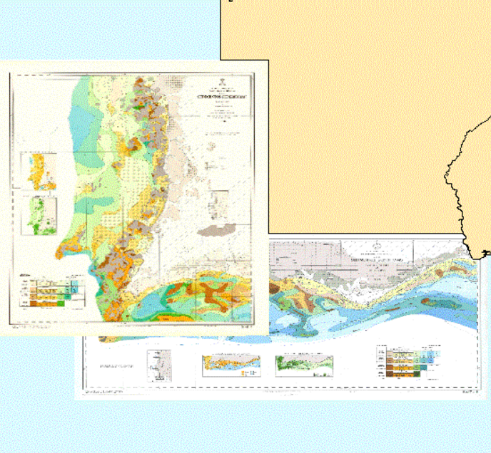
Map of the Superficial Sediments of the Portuguese Continental Shelf
The "Map of the Superficial Sediments of the Portuguese Continental Shelf" is a publication of the Portuguese Hydrographic Institute (IH-PT), funded entirely by the Ministry of National Defence. This cartography, related to the “Sedimentological Series”, consists of 8 sheets at the scale 1:150000, and their explanation notes: SED 1 - De Caminha a Espinho (1.ª edição), SED 2 - De Espinho ao Cabo Mondego (1.ª edição), SED 3 - Do Cabo Mondego ao Cabo Carvoeiro (1.ª edição), SED 4 - Do Cabo Carvoeiro ao Cabo da Roca (1.ª edição), SED 5 - Do Cabo da Roca ao Cabo de Sines (1.ª edição), SED 6 - Do Cabo de Sines ao Cabo de S. Vicente (1.ª edição) e SED 7/8 - Do Cabo de S. Vicente ao Rio Guadiana (2.ª edição). To date, all of the 8 sheets have been published, but only the SED 7/8 sheet has its explanation note produced and edited.
The oceanographic campaigns, carried out by The Portuguese Hydrographic Institute, under the SEPLAT Program, allowed the collection of twelve thousand samples from the seabed surface, covering the continental shelf off mainland Portugal down to 500m of depth. These sediment samples were collected according to an approximately rectangular sampling mesh with 1 nautical mile of average spacing.
The collected sediment samples were subsequently processed in the sedimentology laboratory, providing the necessary information for the sediment classification and mapping. The classification adopted in the "Map of Superficial Sediments of the Portuguese Continental Shelf" is based on particles grain size and calcium carbonate content.
The reference coordinate system used was Mercator Projection - International Ellipsoid - Datum Lisboa.
|
|
Citation proposal
(1985) . Map of the Superficial Sediments of the Portuguese Continental Shelf. https://services.mspdata.eu:/geonetwork/srv/api/records/f00f3416-2904-47ad-81c1-c51f36449404 |
Simple
- Alternate title
- Série Sedimentológica, Carta SEPLAT, Folhas SED
- Date ( Creation )
- 1985-01-01
- Date ( Revision )
- 2010-12-01
- Date ( Publication )
- 1985-01-01
- Identifier
- f00f3416-2904-47ad-81c1-c51f36449404
- Purpose
- A produção destas cartas teve origem no Programa SEPLAT - "Cartografia Sedimentar da Plataforma Continental Portuguesa", cujo objetivo consistiu na representação cartográfica dos sedimentos superficiais do fundo marinho, substituindo as antigas "Cartas Litológicas Submarinas", publicadas entre 1913 e 1941. Este programa, em desenvolvimento no Instituto Hidrográfico desde 1974, é financiado pela Marinha.
- Status
- Contínuo On going
Point of contact
- Maintenance and update frequency
- Não Planeada Not planned
- GEMET - INSPIRE themes, version 1.0 ( Theme )
-
- Geologia
- Keywords ( Theme )
-
- Amostragem de sedimentos marinhos
- Keywords ( Theme )
-
- Carta dos sedimentos
- Keywords ( Theme )
-
- Carbonato de cálcio
- Keywords ( Discipline )
-
- Cartografia sedimentar
- Keywords ( Theme )
-
- IH
- Keywords ( Theme )
-
- INSPIRECORE
- Keywords ( Theme )
-
- Plataforma continental
- Keywords ( Theme )
-
- Portugal continental
- Keywords ( Theme )
-
- Folhas SED
- Keywords ( Theme )
-
- Sedimento
- Keywords ( Theme )
-
- Sedimentos superficiais
- Keywords ( Theme )
-
- Programa SEPLAT
- Keywords ( Theme )
-
- Série sedimentológica
- Keywords ( Theme )
-
- Depósitos sedimentares
- Keywords ( Discipline )
-
- Geologia marinha e costeira
- Keywords ( Theme )
-
- Grab sampler
- Keywords ( Theme )
-
- Navio de investigação
- Keywords ( Theme )
-
- Oceano Atlântico
- Keywords ( Theme )
-
- Carta SEPLAT
- Keywords ( Theme )
-
- Map of the Superficial Sediments of the Portuguese Continental Shelf
- Keywords ( Theme )
-
- Oceanographic campaigns
- Keywords ( Theme )
-
- Sediment samples
- Keywords ( Theme )
-
- SEPLAT Program
- Keywords ( Theme )
-
- Continental shelf
- Keywords ( Theme )
-
- Sedimentology laboratory
- Keywords ( Theme )
-
- Particles grain size
- Keywords ( Theme )
-
- Calcium carbonate sediment content
- Keywords ( Theme )
-
- Upper continental slope
- Keywords ( Theme )
-
- Sedimentary deposits
- Keywords ( Theme )
-
- Seabed surface sediments
- Keywords
-
- Marine sediments grabs
- Keywords
-
- infoMapAccessService
- Keywords
-
- Cartografia Oficial
- Keywords
-
- Cartografia Temática
- Keywords
-
- DL_180_2009_Art20_2e
- Thesaurus SNIMar v.1.x ( Discipline )
-
- Oceanografia
- Thesaurus SNIMar v.1.x ( parameter )
-
- Concentrações de carbono no sedimento
- Thesaurus SNIMar v.1.x ( parameter )
-
- Fundo do Mar
- Thesaurus SNIMar v.1.x ( parameter )
-
- Amostragem de sedimentos marinhos
- Thesaurus SNIMar v.1.x ( parameter )
-
- Depósitos sedimentares
- Thesaurus SNIMar v.1.x ( parameter )
-
- Sedimento
- Thesaurus SNIMar v.1.x ( parameter )
-
- Granulometria sedimentar
- Thesaurus SNIMar v.1.x ( Discipline )
-
- Geologia Marinha e Costeira
- Classification
- Não Classificado Unclassified
- Use limitation
- Com restrições
- Access constraints
- Direitos de Autor Copyright
- Access constraints
- Outras Restrições Other restrictions
- Use constraints
- Direitos de Autor Copyright
- Use constraints
- Outras Restrições Other restrictions
- Other constraints
- Não podem ser utilizados para fins comerciais, mas apenas para fins de utilização pessoal e/ou para fins de investigação e deve ser sempre feita referência à sua origem.
- Other constraints
- A utilização de uma ou mais folhas SED da "Carta dos Sedimentos Superficiais da Plataforma Continental Portuguesa" pressupõe em qualquer caso a obrigatoriedade de referência à sua origem, particularmente no caso de serem utilizadas na produção de publicações científicas.
- Other constraints
- Esta cartografia não se destina a ser utilizada para efeitos de navegação.
- Spatial representation type
- Matricial Grid
- Denominator
- 150000
- Metadata language
- Português Portuguese
- Character set
- utf8 UTF8
- Topic category
-
- Geoscientific information
- Oceans
- Environment
))
- Extent type code
- true
- Geographic identifier
- Lisbon - EPSG:4207
- Extent type code
- true
- Geographic identifier
- Local
- Reference system identifier
- EPSG / http://www.opengis.net/def/crs/EPSG/0/4207
- Distribution format
-
- Papel (não se aplica )
- WMS (não se aplica )
Distributor
- Hierarchy level
- Série Series
Conformance result
- Date ( Publication )
- 2010-12-08
- Explanation
- Ver a especificação citada.
- Pass
- false
- Statement
-
The "Map of the Superficial Sediments of the Portuguese Continental Shelf" is the main product of the SEPLAT Program, funded by the Portuguese Ministry of National Defense since 1974. This program is addressed to the cartographic representation of the sedimentary deposits of the seabed of the continental shelf and the upper continental slope. The program was created to replace the old "Submarine Lithological Maps", published between 1913 and 1941.
The oceanographic campaigns carried out under the SEPLAT program enabled the collection of more than 12000 samples of surface sediments along the entire coast off mainland Portugal (from Minho to the Algarve) from the coastline down to 500 m of depth, using different types of grabs, following a regular sampling distance, with 1 nautical mile average spacing. After being georeferenced, the collected sediment samples were processed in the Sedimentological Laboratory of the Portuguese Hydrographic Institute (IH-PT) in order to apply the classification scheme adopted in the “Map of the Superficial Sediments of the Portuguese Continental Shelf”, based on the particles grain size and their calcium carbonate content.
Metadata
- File identifier
- f00f3416-2904-47ad-81c1-c51f36449404 XML
- Metadata language
- Português Portuguese
- Character set
- utf8 UTF8
- Hierarchy level
- Série Series
- Date stamp
- 2019-05-13
- Metadata standard name
- Perfil SNIMar
- Metadata standard version
- v.0.9.3