Metadata catalogue
Regional Satellite Wind Analyses
Surface wind analysis estimated from remotely sensed surface wind observations. They are determined over tow EBUS: Canay and Benguela.
|
|
Citation proposal
Bentamy Abderrahim (IFREMER) (2021) . Regional Satellite Wind Analyses. IFREMER https://services.mspdata.eu:/geonetwork/srv/api/records/eea4bdf1-cfbc-4efc-8e34-fb69e8f02316 |
Simple
- Date ( Creation )
- 2021-02-16
- Date ( Publication )
- 2021-04-23
- Identifier
- FR-330-715-368-00032-LOPS_WIND_UPWESATWIND
- Identifier
- DOI:10.12770/eea4bdf1-cfbc-4efc-8e34-fb69e8f02316
- Credit
- Ifremer - LOPS
Author
IFREMER
-
Bentamy Abderrahim
Centre Bretagne - ZI de la Pointe du Diable - CS 10070 - 29280 Plouzané
Brest
France
Publisher
- GEMET - INSPIRE themes, version 1.0 ( Theme )
-
- Oceanographic geographical features
- Thèmes Sextant ( Theme )
-
- /Chemical Environment/Water Column
- Access constraints
- Copyright
- Use constraints
- Other restrictions
- Other constraints
- Spatial representation type
- Grid
- Metadata language
- English
- Character set
- UTF8
- Topic category
-
- Oceans
N
S
E
W
))
- Reference system identifier
- EPSG / WGS 84 (EPSG:4326) / 8.6
- Topology level
- Geometry only
- Number of dimensions
- 2
- Dimension name
- Column
- Dimension name
- Row
- Cell geometry
- Area
- Distribution format
-
- ( )
- OnLine resource
- /home/ref-sat-dailywind/
- OnLine resource
-
Main publication
Bentamy Abderrahim, Grodsky Semyon A, Cambon Gildas, Tandeo Pierre, Capet Xavier, Roy Claude, Herbette Steven, Grouazel Antoine (2021). Twenty-Seven Years of Scatterometer Surface Wind Analysis over Eastern Boundary Upwelling Systems . Remote Sensing , 13(5), 940 (28p.) . Publisher's official version : https://doi.org/10.3390/rs13050940 , Open Access version : https://archimer.ifremer.fr/doc/00682/79416/
- OnLine resource
-
DOI of the dataset
DOI of the dataset
- Hierarchy level
- Dataset
- Statement
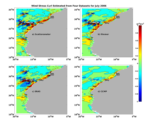
- More than twelve satellite scatterometers have operated since 1992 through the present providing the main source of surface wind vector observations over global oceans. In this study, these scatterometer winds are used in combination with radiometers and synthetic aperture radars (SAR) for better determination and characterization of high spatial and temporal resolution of regional surface wind parameters, including wind speed and direction, wind stress components, wind stress curl and divergence. 27-year long (1992 – 2018) 6-hourly satellite wind analysis with a spatial resolution of 0.125° in latitude and longitude is calculated using spatial structure functions derived from high-resolution SAR data. The main objective is to improve regional winds over three major upwelling regions (the Canary, Benguela, and California regions) through the use of accurate and homogenized wind observations and region-specific spatial and temporal wind variation structure functions derived from buoy and SAR data. The long time series of satellite wind analysis over the California upwelling, where a significant number of moorings is available, are used for assessing the accuracy of the analysis. The latter is close to scatterometer wind retrieval accuracy. This assessment shows that the root-mean-square difference between collocated 6-hourly satellite wind analysis and buoys is lower than 1.50 m s-1 and 1.80 m s-1 for offshore and nearshore locations, respectively. The temporal correlation between buoy and satellite analysis winds exceeds 0.90. The analysis accuracy is lower for 1992 – 1999 when satellite winds were mostly retrieved from ERS-1 and/or ERS-2 scatterometers. To further assess the improvement brought by this new wind analysis, its data and data from three independent products (ERA5, CMEMS, and CCMP) are compared with purely scatterometer winds over the Canary and Benguela regions. Even though the four products are generally similar, the new satellite analysis shows significant improvements, particularly in the upwelling areas.
Metadata
- File identifier
- eea4bdf1-cfbc-4efc-8e34-fb69e8f02316 XML
- Metadata language
- English
- Character set
- UTF8
- Hierarchy level
- Dataset
- Date stamp
- 2021-04-23T11:13:58
- Metadata standard name
- ISO 19115:2003/19139 - SEXTANT
- Metadata standard version
- 1.0
Point of contact
IFREMER
-
Bentamy Abderrahim
Centre Bretagne - ZI de la Pointe du Diable - CS 10070 - 29280 Plouzané
Brest
France