 Metadata catalogue
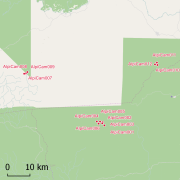
Africadiv Mindourou II: a network of forest monitoring plots in Cameroon since 2013
Africadiv is a network of 1-ha forest monitoring plots spread across the moist forests in central Africa. The Cameroonian site of Mindourou II is composed of 12 1-ha forest plots. The following data are available for the different plots at this site:
Structure - DBH of all trees ≥ 10 cm DBH : n = 5 598
Structure - Tree height : n = 920
Structure - Trunk height : n = 667
Structure - Crown diameter : n = 233
Identification rate - species-level : 56.4 %
Identification rate - genus-level : 26.2 %
Identification rate - family-level : 11.7 %
Identification rate - unidentified : 5.7 %
Soil samples & analyses available : YES
Geolocation : GPS points and laser measurements (distance, vertical & horizontal angles) every 20 m on the contour of the plot.
These data are routinely collected and used by AMAP research unit (IRD) and partners (LaboSyst, Yaoundé 1 University). Scientific collaboration are welcomed, please get in touch with a Point of contact.
|
|
Citation proposal
. Africadiv Mindourou II: a network of forest monitoring plots in Cameroon since 2013. https://services.mspdata.eu:/geonetwork/srv/api/records/e38228b9-f369-4409-bf21-8ae332fc5f1e |
Simple
- Date ( Creation )
- 2017-06-26
- Identifier
- IRD-AMAP-Africadiv-Mindourou02
- Status
- On going
Point of contact
Point of contact
- Maintenance and update frequency
- As needed
- GEMET - INSPIRE themes, version 1.0 INSPIRE themes ( Theme )
-
- Environmental monitoring facilities
- Geounits ( Place )
-
- Africa , Middle Africa , Cameroon
- GEMET - Concepts, version 2.4 ( Theme )
-
- forest resource assessment , tropical forest , biomass
- Keywords
-
- local coverage , Project PPR FTH , Africadiv
- Keywords ( Theme )
-
- sampling plots , mesoscale plot network , forest structure , tropical forest types , forest composition , above ground biomass , height diameter relationship , forest diversity , forest carbon , REDD+ , tree allometry
- Keywords ( Place )
-
- Mindourou II
- Use limitation
- Disclaimer - While every effort has been made to ensure that these data are accurate and reliable within the limits of the current state of the art, IRD cannot assume liability for any damages caused by any errors or omissions in the data, nor as a result of the failure of the data to function on a particular system. IRD makes no warranty, expressed or implied, nor does the fact of distribution constitute such a warranty.
- Access constraints
- Other restrictions
- Other constraints
- Please get in touch with a point of contact.
- Classification
- Unclassified
- Spatial representation type
- Text, table
- Denominator
- 5000
- Metadata language
- eng
- Character set
- UTF8
- Topic category
-
- Biota
))
))
))
- Supplemental Information
- Associated references:
- Reference system identifier
- EPSG / WGS 84 (EPSG:4326) / 7.9
- Distribution format
-
- Text (1 )
- Hierarchy level
- Dataset
- Other
- Statement
- not defined
Metadata
- File identifier
- e38228b9-f369-4409-bf21-8ae332fc5f1e XML
- Metadata language
- eng
- Character set
- UTF8
- Parent identifier
- 8fcc7095-816f-4b71-a499-bc9e7d65410a
- Hierarchy level
- Dataset
- Hierarchy level name
- Date stamp
- 2017-07-11T19:06:19
- Metadata standard name
- ISO 19115:2003/19139
- Metadata standard version
- 1.0
Point of contact
Point of contact
Point of contact
Overviews

Provided by
