Metadata catalogue
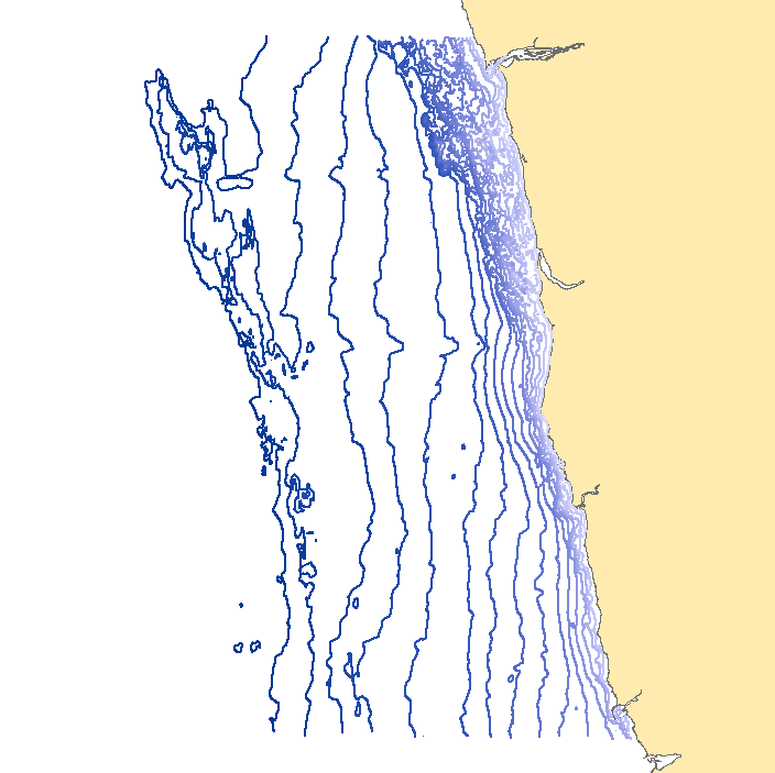
Isobathymetric model from Viana do Castelo to Leixões
This dataset contains contour lines with 5 and10 meters step, built on sounding information from the hydrographic surveys conducted in the area from Viana do Castelo to Leixões.
|
|
Citation proposal
. Isobathymetric model from Viana do Castelo to Leixões. https://services.mspdata.eu:/geonetwork/srv/api/records/de24cfed-052b-4b34-ab98-818e0562bc65 |
Simple
- Alternate title
-
Modelo isobatimétrico de Viana do Castelo e Leixões
- Date ( Creation )
- 2013-07-26
- Identifier
-
a263836f-c855-4418-850d-906465a166c2
- Status
- Concluído Completed
Point of contact
- Website
- http://www.hidrografico.pt
Originator
- Website
- http://www.hidrografico.pt
- Maintenance and update frequency
- Irregular Irregular
- GEMET - INSPIRE themes, version 1.0 ( Theme )
-
-
Altitude
-
- Keywords ( Place )
-
-
Viana do Castelo
-
- Keywords ( Place )
-
-
Leixões
-
- Keywords
-
-
IH
-
- Keywords ( Theme )
-
-
DL_180_2009_Art20_2e
-
- Thesaurus SNIMar v.0.x ( parameter )
-
-
Profundidade
-
- Thesaurus SNIMar v.0.x ( parameter )
-
-
Sonda Reduzida
-
- Thesaurus SNIMar v.0.x ( platform )
-
-
Navio de Investigação
-
- Thesaurus SNIMar v.0.x ( parameter )
-
-
Modelo batimétrico
-
- Thesaurus SNIMar v.0.x ( parameter )
-
-
Batimetria
-
- Thesaurus SNIMar v.0.x ( Discipline )
-
-
Batimetria e Geomorfologia Marinha
-
- Thesaurus SNIMar v.0.x ( instrument )
-
-
Sondador de feixe simples
-
- Thesaurus SNIMar v.0.x ( instrument )
-
-
Sondador multifeixe
-
- Thesaurus SNIMar v.0.x ( parameter )
-
-
Isóbata
-
- Classification
- Não Classificado Unclassified
- Use limitation
-
Com restrições
- Access constraints
- Outras Restrições Other restrictions
- Use constraints
- Direitos de Propriedade Intelectual Intellectual property rights
- Other constraints
-
Estes dados não podem ser utilizados para fins comerciais, mas apenas para fins de utilização pessoal e/ou para fins de investigação e deve ser sempre feita referência à sua origem, no caso de serem utilizados na produção de publicações científicas.
- Other constraints
-
Estes dados não substituem as cartas náuticas; não podem ser utilizados para navegação.
- Spatial representation type
- Vectorial Vector
- Denominator
- -1
- Metadata language
- Português Portuguese
- Character set
- utf8 UTF8
- Topic category
-
- Oceans
- Elevation
))
- Extent type code
- true
- Geographic identifier
-
Local
Vertical extent
- Minimum value
- 0.001
- Maximum value
- 100.0
- Reference system identifier
-
EPSG
/
- Distribution format
-
-
ESRI Shapefile
(N/A
)
-
Distributor
- Website
- http://www.hidrografico.pt
- Transfer size
- 5.01
- OnLine resource
- http://www.hidrografico.pt/op/33
- Hierarchy level
- Conjunto de Dados Geográficos Dataset
Conformance result
- Date ( Publication )
- 2010-12-08
- Explanation
-
Ver a especificação citada.
- Pass
- false
- Statement
-
This dataset was created by the Hydrography Division. The contour lines were generated using the data from hydrographic surveys in the area. The spacing between the lines is: 0-50 m depth - 5 m spacing; 50-100 m depth - 10m spacing.
The data available for free download are only reference data, not official.
Metadata
- File identifier
- de24cfed-052b-4b34-ab98-818e0562bc65 XML
- Metadata language
- Português Portuguese
- Character set
- utf8 UTF8
- Hierarchy level
- Conjunto de Dados Geográficos Dataset
- Date stamp
- 2019-03-27
- Metadata standard name
-
Perfil SNIMar
- Metadata standard version
-
v.0.9.3
Point of contact
- Website
- http://www.hidrografico.pt