Metadata catalogue
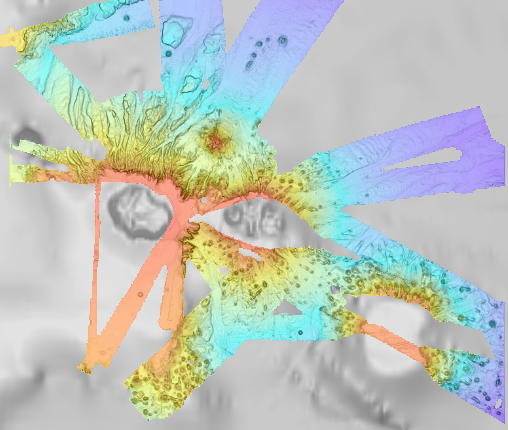
Bathymétrie - Archipel de Crozet (synthèse, 2025), résolution 100 m
Bathymétrie de l'archipel de Crozet, au pas de 100 mètres. Ce Modèle Numérique de Terrain est une compilation de données bathymétriques issues de différentes sources.
Référence verticale : Niveau observé des mers (pas de correction)
Les données sont issues des campagnes :
- SCHLICH Roland (1998) KERIMIS-MD109 cruise, RV Marion Dufresne, https://doi.org/10.17600/98200010
- HUMLER Eric (2001) MD 121 / SWIFT cruise, RV Marion Dufresne, https://doi.org/10.17600/1200030
- METZL Nicolas, PIERRE Catherine (2001) VT 51 / OISO 6 cruise, RV Marion Dufresne, https://doi.org/10.17600/1200010
- ASLANIAN Daniel, HUMLER Eric, MICHEL Elisabeth (2002) MD 125 / SWIFT BIS-CARHOT cruise, RV Marion Dufresne, https://doi.org/10.17600/2200020
- MICHEL Elisabeth (2004) MD 136 / VIGO cruise, RV Marion Dufresne, https://doi.org/10.17600/4200110
- ROEST Walter (2005) MD 150 /DELCANO RISE-KERGUEPLAC2 cruise, RV Marion Dufresne, https://doi.org/10.17600/5200060
- VIALLY Roland, BRUNET Christian, ROYER Jean-Yves (2008) MD 165 / KERGUEPLAC 3 cruise, RV Marion Dufresne, https://doi.org/10.17600/8200010
- ROEST Walter, JOHNSON Sean (2010) MD176 Discovery Ridge-CrozetPlac cruise, RV Marion Dufresne, https://doi.org/10.17600/18001444
- CROSTA Xavier (2019) MD 218 / CROTALE cruise, RV Marion Dufresne, https://doi.org/10.17600/18000886
- transit du R/V Marion Dufresne MD202 (2016)
- transit du R/V Marion Dufresne MD207 (2017)
- MAZAUD Alain, MICHEL Elisabeth (2012) MD 189 / INDIEN SUD 2 cruise, RV Marion Dufresne, https://doi.org/10.17600/12200010
- MD 247
|
|
Citation proposal
Geo-Ocean (UMR 6538) (Ifremer) - LOUBRIEU Benoît (Ifremer) (2022) . Bathymétrie - Archipel de Crozet (synthèse, 2025), résolution 100 m. Ifremer https://services.mspdata.eu:/geonetwork/srv/api/records/daed529e-eba2-4286-8cd9-677516c3ccdb |
Simple
- Date ( Publication )
- 2022-08-05
- Date ( Creation )
- 2013-03-01
- Date ( Revision )
- 2022-07-22
- Date ( Revision )
- 2025-08-11
- Identifier
- FR-330715-368-00032-Synthese_Crozet_100m_BATHY
- Credit
- Ifremer
Author
Publisher
- Thèmes Sextant Thèmes Sextant ( Theme )
-
- /Milieu physique/Bathymétrie /Milieu physique/Bathymétrie /Physical Environment/Bathymetry
- GEMET - INSPIRE themes, version 1.0 GEMET - INSPIRE themes, version 1.0 ( Theme )
-
- Altitude Altitude Elevation
- GEMET - Concepts, version 2.4 GEMET - Concepts, version 2.4 ( Theme )
-
- morphologie sous-marine morphologie sous-marine submarine morphology , fond marin fond marin sea bed
- Keywords ( Discipline )
-
- Bathymétrie
- Type de jeux de donnée ODATIS Type de jeux de donnée ODATIS ( Theme )
-
- Données combinées
- ODATIS aggregation parameters and Essential Variable names ODATIS aggregation parameters and Essential Variable names ( Theme )
-
- Bathymétrie
- Use limitation
- CC-BY (Creative Commons - Attribution) CC-BY (Creative Commons - Attribution) CC-BY (Creative Commons - Attribution)
- Access constraints
- Other restrictions
- Use constraints
- License
- Other constraints
- Pas de restriction d'accès public
- Use limitation
- Ne pas utiliser pour la navigation
- Spatial representation type
- grid Grid
- Distance
- 100 meter
- Metadata language
- French
- Character set
- utf8 UTF8
- Topic category
-
- Oceans
))
- Codespace
- EPSG
- Version
- 7.4
Spatial representation info
- Number of dimensions
- 2
- Cell geometry
- Area
- Distribution format
-
- GeoTIFF (1.0 )
- OnLine resource
- Synthese_Crozet_100m_BATHY
- Protocol
- COPYFILE
- Name
- Synthese_Crozet_100m_BATHY
- Description
- OnLine resource
- Rapport de traitement
- OnLine resource
- Digital Object Identifier (DOI)
- OnLine resource
-
Synthese_Crozet_100m_BATHY
Synthese_Crozet_100m_BATHY
- Hierarchy level
- Dataset
Domain consistency
Conformance result
- Date ( Publication )
- 2010-12-08
- Explanation
- See the referenced specification
- Statement
-
Ce MNT résulte d'une synthèse des données de sondeur multifaisceaux, disponible dans la région de l'Archipel de Crozet.
Une première version a été réalisée en 2013 :
Rapport de traitement : Loubrieu Benoit, Pierre Delphine, Biville Romain, Le Duff Mathilde (2013). Digital Terrain Model for the HA04 hydroacoustic station, Crozet Islands, France. CB/GM/CTDI-BL2013-01.
Par la suite, le MNT est mis à jour avec des données bathymétriques acquises au cours de campagnes océanographiques du N/O Marion Dufresne.
Metadata
- File identifier
- daed529e-eba2-4286-8cd9-677516c3ccdb XML
- Metadata language
- French
- Character set
- UTF8
- Hierarchy level
- Dataset
- Date stamp
- 2025-08-25T13:38:21.007375Z
- Metadata standard name
- ISO 19115-3 - SEXTANT ISO 19115-3 - SEXTANT
- Metadata standard version
- 1.0