Metadata catalogue
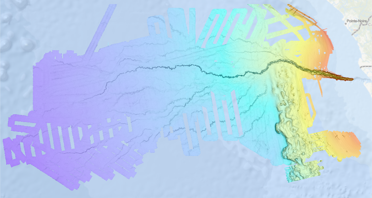
Bathymétrie - éventail turbiditique du Congo (synthèse, 2013)
Bathymétrie de l'éventail du Congo, au pas de 100 mètres. Ce Modèle Numérique de Terrain est une compilation de données bathymétriques acquises par sondeur multifaisceau, créée en 2013.
Description des campagnes :
- VANGRIESHEIM Annick (2005) BIOZRECUP2 cruise, RV Beautemps-Beaupré, https://doi.org/10.17600/5090030
- COCHONAT Pierre, ROBIN Agnès (1992) GUINESS I cruise, RV L'Atalante, https://doi.org/10.17600/92004 211
- OPTIC CONGO 2
- MARSSET Tania, DROZ Laurence (2010) REPREZAI_LEG1 cruise, RV Pourquoi pas ?, https://doi.org/10.17600/10030170
- OLU Karine (2011) WACS cruise, RV Pourquoi pas ?, https://doi.org/10.17600/11030010
- SAVOYE Bruno (1998) ZAIANGO1 cruise, RV L'Atalante, https://doi.org/10.17600/98010100
- COCHONAT Pierre (1998) ZAIANGO2 cruise, RV L'Atalante, https://doi.org/10.17600/98010110
- BOURILLET Jean-François (2000) ZAIANGOCAR cruise, RV Le Suroît, https://doi.org/10.17600/20050
- GELI Louis (2000) ZAIANGO-OBS-BIOL cruise, RV Le Suroît, https://doi.org/10.17600/20040
|
|
Citation proposal
Geo-Ocean (UMR 6538) (Ifremer). Bathymétrie - éventail turbiditique du Congo (synthèse, 2013). Ifremer https://services.mspdata.eu:/geonetwork/srv/api/records/d1076601-82a9-42a2-9d30-d0be8b2481a7 |
Simple
- Date ( Creation )
- 2013-10-03
- Date ( Revision )
- 2018-12-21
- Identifier
-
FR-330715-368-00032-Synthese_Congo_100m_BATHY
- Identifier
-
DOI:10.12770/d1076601-82a9-42a2-9d30-d0be8b2481a7
Point of contact
- Presentation form
- Digital model
- Credit
-
Ifremer
- Status
- completed Completed
Publisher
- Maintenance and update frequency
- As needed
- Keywords ( Discipline )
-
-
Bathymétrie
-
- GEMET - INSPIRE themes, version 1.0 GEMET - INSPIRE themes, version 1.0 ( Theme )
-
- Altitude Altitude Elevation
- GEMET GEMET ( Theme )
-
-
Fond marin
,Morphologie sous-marine
-
- Thèmes Sextant Thèmes Sextant ( Theme )
-
- /Milieu physique/Bathymétrie/MNT /Milieu physique/Bathymétrie/MNT /Physical Environment/Bathymetry/Digital Terrain Model
- Use limitation
- CC-BY (Creative Commons - Attribution) CC-BY (Creative Commons - Attribution) CC-BY (Creative Commons - Attribution)
- Use limitation
- Ne pas utiliser pour la navigation Ne pas utiliser pour la navigation
- Access constraints
- Other restrictions
- Use constraints
- License
- Other constraints
-
Pas de restriction d'accès public
- Spatial representation type
- grid Grid
- Distance
- 100 m
- Denominator
- 200000
- Metadata language
- French
- Character set
- utf8 UTF8
- Topic category
-
- Elevation
- Environment description
-
Version 6.2 (Build 9200) ; Esri ArcGIS 10.3.1.4959
))
- Number of dimensions
- 2
- Dimension name
- Column
- Dimension size
- 9305
- Resolution
- 100 m
- Dimension name
- Row
- Dimension size
- 4697
- Resolution
- 100 m
- Cell geometry
- Area
- Transformation parameter availability
- true
- Checkpoint Availability
- false
Center point
- Point in Pixel
-
- centre
- Distribution format
-
-
Raster Dataset
()
-
- OnLine resource
- FR-330715-368-00032-Synthese_Congo_100m_BATHY
- Protocol
-
COPYFILE
- Name
-
FR-330715-368-00032-Synthese_Congo_100m_BATHY
- OnLine resource
-
DOI du jeu de donnée
DOI du jeu de donnée
- OnLine resource
-
Campagne BIOZRECUP2
BIOZRECUP2 cruise
- OnLine resource
-
Campagne GUINESS I
GUINESS I cruise
- OnLine resource
-
Campagne REPREZAI_LEG1
REPREZAI_LEG1 cruise
- OnLine resource
-
Campagne WACS
WACS cruise
- OnLine resource
-
Campagne ZAIANGO1
ZAIANGO1 cruise
- OnLine resource
-
Campagne ZAIANGO2
ZAIANGO2 cruise
- OnLine resource
-
Campagne ZAIANGOCAR
ZAIANGOCAR cruise
- OnLine resource
-
Campagne ZAIANGO-OBS-BIOL
ZAIANGO-OBS-BIOL cruise
- Hierarchy level
- Dataset
- Statement
-
Pas d'information sur le traitement des données.
Metadata
- File identifier
- d1076601-82a9-42a2-9d30-d0be8b2481a7 XML
- Metadata language
- French
- Character set
- UTF8
- Hierarchy level
- Dataset
- Hierarchy level name
-
dataset
- Date stamp
- 2025-11-28T17:15:50.74803Z
- Metadata standard name
-
ISO 19115-3 - SEXTANT ISO 19115-3 - SEXTANT
- Metadata standard version
-
1.0