Metadata catalogue
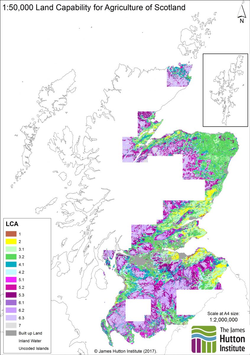
1:50,000 Land Capability for Agriculture
The Land Capability Classification for Agriculture has as its objective the presentation of detailed information on soil, climate and relief in a form which will be of value to land use planners, agricultural advisers, farmers and others involved in optimising the use of land resources. The classification ranks land on the basis of its potential productivity and cropping flexibility determined by the extent to which its physical characteristics (soil, climate and relief) impose long term restrictions on its agricultural use.
THE CLASSES
Class 1. Land capable of producing a very wide range of crops with high yields
Class 2. Land capable of producing a wide range of crops with yields less high than Class 1.
Class 3. Land capable of producing good yields from a moderate range of crops.
Class 4. Land capable of producing a narrow range of crops.
Class 5. Land suited only to improved grassland and rough grazing.
Class 6. Land capable only of use as rough grazing.
Class 7. Land of very limited agricultural value.
THE DIVISIONS
A division is a ranking within a class. As the requirements of the crops suited to Classes 1 and 2 are fairly stringent, land in these classes has inherently low degrees of internal variability and no divisions are present.
The requirements of crops grown in the remaining classes are less rigorous, consequently land included is more variable in character.
|
|
Citation proposal
(2014) . 1:50,000 Land Capability for Agriculture. https://services.mspdata.eu:/geonetwork/srv/api/records/cfa70edc-8884-433d-b1f3-3970f5b4b047 |
Simple
- Alternate title
-
Land capability for agriculture (partial cover)
- Date ( Publication )
- 2014-04-01T00:00:00
- Edition
-
1.0
- Identifier
-
cfa70edc-8884-433d-b1f3-3970f5b4b047_resource
- Purpose
-
To provide information on the agricultural land capability for the more intensively farmed areas of Scotland.
- Status
- completed Completed
Distributor
- Maintenance and update frequency
- notPlanned Not planned
- Name
-
ESRI Shapefile
- Version
-
1.0
- Keywords
-
-
agriculture
-
- GEMET - INSPIRE themes, version 1.0 ( Theme )
-
-
Soil
,Land use
-
- Access constraints
- otherRestrictions Other restrictions
- Other constraints
-
no limitations on public access
- Use limitation
-
Suitable for use at medium scales. Data of national coverage is available at 1:250,000 scale.
- Use limitation
-
The James Hutton Institute Open Data Licence
- Spatial representation type
- vector Vector
- Denominator
- 50000
- Metadata language
- eng English
- Topic category
-
- Farming
- Geoscientific information
))
- Geographic identifier
-
GB-SCT
- Reference system identifier
-
EPSG
/OSGB 1936 / British National Grid (EPSG:27700)
/7.9
- Distribution format
-
-
ESRI Shapefile
(1.0
)
-
Distributor
Distributor
Craigiebuckler
Aberdeen
AB15 8QH
United Kingdom
- Name
-
ESRI Shapefile
- Version
-
1.0
- OnLine resource
-
ESRI Shapefile Download
A zip of the Esri shapefile, including licence and Esri layer files.
- OnLine resource
-
50K LCA WMS
1:50,000 Land Capability for Agriculture
- Hierarchy level
- Dataset
- Dataset
-
Shapefile
- Statement
-
Digitised from the paper maps published in the 1980's. Please refer to the information for the 1:250,000 LCA for further details.
Metadata
- File identifier
- cfa70edc-8884-433d-b1f3-3970f5b4b047 XML
- Metadata language
- eng English
- Hierarchy level
- dataset Dataset
- Date stamp
- 2018-02-08
- Metadata standard name
-
ISO 19115:2003/19139
- Metadata standard version
-
1.0