Metadata catalogue
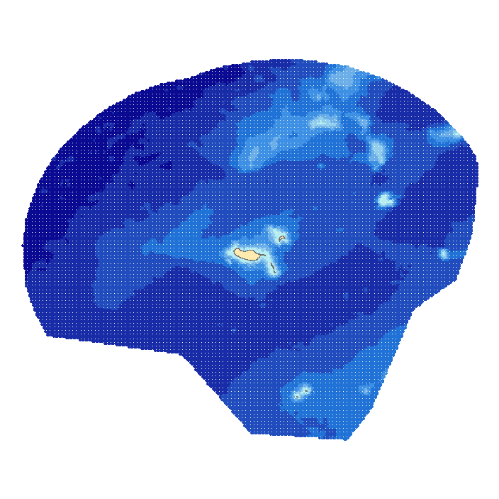
Bathymetric model of Madeira Archipelago
This dataset contains a depth grid with 2 miles spacing, built on sounding information the Portuguese Hydrographic Institute (IH) and GEBCO (2008). The depth values are referred to the Hydrographical Zero (ZH).
|
|
Citation proposal
. Bathymetric model of Madeira Archipelago. https://services.mspdata.eu:/geonetwork/srv/api/records/bb3810ba-76f5-476b-b7e2-ef399a0f4fc0 |
Simple
- Alternate title
-
Batimetria do Arquipélago da Madeira
- Date ( Creation )
- 2010-07-26
- Identifier
-
9557D11A-3E95-4FBE-8285-9B2E1B44712B
- Status
- Concluído Completed
Point of contact
- Website
- http://www.hidrografico.pt
Originator
- Website
- http://www.hidrografico.pt
- Maintenance and update frequency
- Irregular Irregular
- GEMET - INSPIRE themes, version 1.0 ( Theme )
-
-
Altitude
-
- Keywords
-
-
IH
-
- Keywords ( Theme )
-
-
DL_180_2009_Art20_2e
-
- Thesaurus SNIMar v.0.x ( parameter )
-
-
Profundidade
-
- Thesaurus SNIMar v.0.x ( parameter )
-
-
Sonda Reduzida
-
- Thesaurus SNIMar v.0.x ( parameter )
-
-
Levantamento Hidrográfico
-
- Thesaurus SNIMar v.0.x ( parameter )
-
-
Zero Hidrográfico
-
- Thesaurus SNIMar v.0.x ( platform )
-
-
Navio de Investigação
-
- Thesaurus SNIMar v.0.x ( parameter )
-
-
Modelo batimétrico
-
- Thesaurus SNIMar v.0.x ( parameter )
-
-
Batimetria
-
- Thesaurus SNIMar v.0.x ( Discipline )
-
-
Batimetria e Geomorfologia Marinha
-
- Thesaurus SNIMar v.0.x ( instrument )
-
-
Sondador de feixe simples
-
- Thesaurus SNIMar v.0.x ( instrument )
-
-
Sondador multifeixe
-
- Thesaurus SNIMar v.0.x ( Place )
-
-
Região Autónoma da Madeira
-
- Thesaurus SNIMar v.0.x ( Place )
-
-
Ilha da Madeira
-
- Classification
- Não Classificado Unclassified
- Use limitation
-
Com restrições
- Access constraints
- Outras Restrições Other restrictions
- Use constraints
- Direitos de Propriedade Intelectual Intellectual property rights
- Other constraints
-
Estes dados não podem ser utilizados para fins comerciais, mas apenas para fins de utilização pessoal e/ou para fins de investigação e deve ser sempre feita referência à sua origem, no caso de serem utilizados na produção de publicações científicas.
- Spatial representation type
- Vectorial Vector
- Distance
- 0.0333 http://standards.iso.org/ittf/PubliclyAvailableStandards/ISO_19139_Schemas/resources/uom/ML_gmxUom.xml#deg
- Metadata language
- Português Portuguese
- Character set
- utf8 UTF8
- Topic category
-
- Oceans
- Elevation
))
- Extent type code
- true
- Geographic identifier
-
Local
Vertical extent
- Minimum value
- 1.124
- Maximum value
- 5777.862
- Reference system identifier
-
EPSG
/
- Distribution format
-
-
ASCII
(N/A
) -
ESRI Shapefile
(N/A
)
-
Distributor
- Website
- http://www.hidrografico.pt
- Transfer size
- 0.9
- Hierarchy level
- Conjunto de Dados Geográficos Dataset
Conformance result
- Date ( Publication )
- 2010-12-08
- Explanation
-
Ver a especificação citada.
- Pass
- false
- Statement
-
The depth grid resulted from surveys of IH and 2008 GEBCO information. A digital terrain model was built by Delaunay triangulation (TIN), then points with equal spacing of 2 nautical miles (2 minutes) were exported from it.
These depth values are referred to the Hydrographical Zero (ZH). The Hydrographical Zero is an established reference plane, situated below the Lowest Astronomical Tide level, which is used as a reference for the soundings and isobathymetric lines represented on the charts. On the archipelago of the Azores the ZH is set 1,0 m below the Mean Sea Level.
The data available for free download are only reference data, not official.
- Description
-
General Bathymetric Chart of the Oceans (GEBCO) 2008
Metadata
- File identifier
- bb3810ba-76f5-476b-b7e2-ef399a0f4fc0 XML
- Metadata language
- Português Portuguese
- Character set
- utf8 UTF8
- Hierarchy level
- Conjunto de Dados Geográficos Dataset
- Date stamp
- 2019-03-27
- Metadata standard name
-
Perfil SNIMar
- Metadata standard version
-
v.0.9.3
Point of contact
- Website
- http://www.hidrografico.pt