 Metadata catalogue
INSS INFOMAR Seabed Survey Sound Velocity Profile
The INtegrated Mapping FOr the Sustainable Development of Ireland's MArine Resource (INFOMAR) programme is a joint venture between the Geological Survey of Ireland (GSI) and the Marine Institute (MI). The programme is the successor to the Irish National Seabed Survey (INSS) and concentrates on creating integrated mapping products related to the seabed. A sound velocity profile shows the speed of sound in water at different vertical levels. It has two general representations:
1. tabular form, with pairs of columns corresponding to ocean depth and the speed of sound at that depth, respectively.
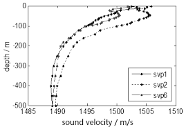
2. a plot of the speed of sound in the ocean as a function of depth, where the vertical axis corresponds to the depth and the horizontal axis corresponds to the sound speed. By convention, the horizontal axis is placed at the top of the plot, and the vertical axis is labeled with values which increase from top to bottom, thus reproducing visually the ocean from its surface downward.
A Sound Velocity Profile (SVP) is a measurement of the speed of sound in water. SVP data is collected during multi-beam surveying for calibration purposes to ground-truth the bathymetric and backscatter data collection.
Data for SVP point locations and associated attribute values is generated from SVP profiler during survey. Data includes XY Longitude Latitude, Start SVP, End SVP, Maximum Depth, Data Quality and Comments, SVP Instrument Name and Survey Leg name.
|
|
Citation proposal
(2013) . INSS INFOMAR Seabed Survey Sound Velocity Profile. https://services.mspdata.eu:/geonetwork/srv/api/records/b53a26df-cb85-47bf-9c2e-6e5590789733 |
Simple
- Alternate title
-
OF.PointObservation.IE.GeologicalSurveyIreland-MarineInstitute.INSS-INFOMAR.SoundVelocityProfile.2000-2020
- Date ( Creation )
- 2000-01-01T00:00:00
- Date ( Publication )
- 2013-06-20T09:59:00
- Date ( Revision )
- 2021-02-19T00:00:00
- Identifier
-
INSPIRE UUID
/OF.PointObservation.IE.GeologicalSurveyIreland-MarineInstitute.INSS-INFOMAR.SoundVelocityProfile.2000-2020
/1.0
- Purpose
-
Seabed mapping of the Irish marine resource calibration and water column behaviour related to multi-beam echosounding.
- Status
- On going
Point of contact
Beggars Bush Barracks
Haddington Road
Dublin 4
D04 K7X4
Ireland
- Maintenance and update frequency
- Annually
- GemetInspireTheme ( Theme )
-
-
Oceanographic geographical features
-
- GEMET - Concepts, version 4.1.2, 16 Aug 2018 ( Theme )
-
-
ocean, sea, sea bed, map, mapping, survey, sound, sound emission, sound level, submarine morphology, monitoring technique
-
- dbpedia.org ( Theme )
-
-
seabed, seafloor mapping, bathymetry, bathymetric survey, bathymetric surveying
-
- GEMET - Concepts, version 4.1.2, 16 Aug 2018 ( Discipline )
-
-
science, earth science, geology, marine geology, hydrography
-
- GeoNames 2012 November, Version 3.1 ( Place )
-
-
Ireland
-
- SeaDataNet sea areas ( Place )
-
-
Atlantic Ocean, North Atlantic Ocean, North East Atlantic Ocean (limit 40W), Celtic Sea, Irish Sea and St. George's Channel
-
- GEMET - Concepts, version 4.1.2, 16 Aug 2018 ( Stratum )
-
-
hydrosphere, lithosphere
-
- European Directory of Marine Organisations ( Theme )
-
-
Geological Survey Ireland, Marine Institute
-
- European Research Vessels Infobase ( Theme )
-
-
RV Celtic Explorer, RV Celtic Voyager, RV Keary, RV Geo, RV Tonn, RV Mallet, RV Lir, M.V. Cosantoir Bradán
-
- European Directory of Marine Environmental Research Projects ( Theme )
-
-
INFOMAR, EMODnet Bathymetry, InisHydro, CHERISH
-
- dbpedia.org ( Theme )
-
-
sound speed profile
-
- Mission Atlantic - Resources ( Theme )
-
-
Data
-
- Mission Atlantic - Case Studies ( Theme )
-
-
Celtic Seas
-
- Mission Atlantic - BODC Parameters ( Theme )
-
-
/Physical oceanography/Acoustics
-
- Mission Atlantic - Data type (DMP) ( Theme )
-
-
Acoustic data
-
- Mission Atlantic - Work Package ( Theme )
-
-
WP4 Benthic Mapping
-
- Use limitation
-
Creative Commons Attribution 4.0 International (CC BY 4.0) licence
- Use limitation
-
Creative Commons Attribution 4.0 International (CC-BY 4.0)
- Access constraints
- License
- Use constraints
- License
- Other constraints
-
https://creativecommons.org/licenses/by/4.0/
Rights (can)
Share- copy and redistribute the data in any medium or format
Adapt- remix, transform, and build upon the material for any purpose, even commercially
Requirements (must)
Attribution- Give appropriate credit, provide a link to the licence, and indicate if changes were made. Do so in any reasonable manner, but not in any way that suggests the license endorses you or your use
No additional restrictions - may not apply legal terms or technological measures that legally restrict others from doing anything the license permits
Under the CC-BY Licence, users must acknowledge the source of the Information in their product or application.
Please use this specific attribution statement: "Contains Irish Public Sector Data (Geological Survey Ireland & Marine Institute) licensed under a Creative Commons Attribution 4.0 International (CC BY 4.0) licence".
- Spatial representation type
- Grid
- Denominator
- 100000
- Metadata language
- English
- Character set
- UTF8
- Topic category
-
- Oceans
- Geoscientific information
- Environment
))
- Time period
- 2000-01-01T00:00:002021-01-19T23:45:00
Vertical extent
- Minimum value
- -4600
- Maximum value
- -20
Vertical CS
Vertical datum
- Supplemental Information
-
SVP point database.
- Reference system identifier
-
EPSG URI
/- Alternate title
-
EPSG Projected Coordinate System
- Date ( Revision )
- 2007-08-27
- Distribution format
-
-
KML, JSON, WMS, WFS
(v2.2, v4.0, v1.3.0, v2.0
)
-
Distributor
Beggars Bush Barracks
Haddington Road
Dublin 4
D04 K7X4
Ireland
- OnLine resource
- Download KML
- OnLine resource
- Download JSON
- OnLine resource
- WFS GetCapabilities
- OnLine resource
- WMS GetCapabilities
- Hierarchy level
- Dataset
Conformance result
- Alternate title
-
INSPIRE Data Specifications v3.0
- Date ( Publication )
- 2013-12-10
- Explanation
-
The INSPIRE Directive or INSPIRE lays down a general framework for a Spatial Data Infrastructure (SDI) for the purposes of European Community environmental policies and policies or activities which may have an impact on the environment.
- Pass
- false
Conformance result
- Alternate title
-
INSPIRE Interoperability Regulation
- Date ( Publication )
- 2010-12-08
- Explanation
-
Level of conformance with the COMMISSION REGULATION (EU) No 1089/2010 of 23 November 2010 implementing Directive 2007/2/EC of the European Parliament and of the Council as regards interoperability of spatial data sets and services
- Pass
- false
- Statement
-
Survey coverage area data is produced each year after the survey season is complete.
Metadata
- File identifier
- b53a26df-cb85-47bf-9c2e-6e5590789733 XML
- Metadata language
- English
- Character set
- UTF8
- Hierarchy level
- Dataset
- Date stamp
- 2022-01-19T16:11:08
- Metadata standard name
-
ISDI Metadata Profile
- Metadata standard version
-
1.2
Author
Beggars Bush Barracks
Haddington Road
Dublin 4
D04 K7X4
Ireland
Overviews


Provided by
