Metadata catalogue
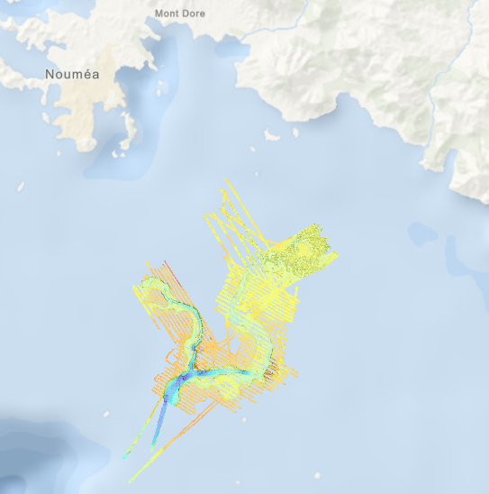
Bathymétrie - Nouvelle-Calédonie, passes de Boulari (campagne CALICO, 2013)
Bathymétrie des passes de Boulari, en Nouvelle-Calédonie, au pas de 2 mètres. Ce jeu de données est un Modèle Numérique de Terrain bathymétrique, issu de l'acquisition acoustique du sondeur multifaisceaux EM1002 du N/O L'Alis.
Rapport de traitement : Guerin Charline (2013). CALICO – N/O Alis. Acquisition et traitement SMF EM1002. Alimentation du SIG. DIT.REM/GM/CTDI-2131106-CG01.
Référence verticale: Niveau des plus basses mers astronomiques NBMA (LAT)
Description de la campagne : LE ROY Pascal, JORRY Stéphan (2013) CALICO cruise, RV Alis, https://doi.org/10.17600/13100080
|
|
Citation proposal
Geo-Ocean (UMR 6538) (2024) . Bathymétrie - Nouvelle-Calédonie, passes de Boulari (campagne CALICO, 2013). Ifremer https://services.mspdata.eu:/geonetwork/srv/api/records/a1dba6d1-9c2b-4a52-ba6c-905e2d212388 |
Simple
- Date ( Publication )
- 2024-01-26
- Date ( Creation )
- 2014-10-24
- Identifier
- FR-330715-368-00032-CALICO_Boulari_2m_BATHY
- Credit
- Geo-Ocean (UMR 6538)
Author
Publisher
Point of contact
Point of contact
- Thèmes Sextant Thèmes Sextant ( Theme )
-
- /Milieu physique/Bathymétrie
- GEMET - INSPIRE themes, version 1.0 GEMET - INSPIRE themes, version 1.0 ( Theme )
-
- Altitude
- GEMET - Concepts, version 2.4 GEMET - Concepts, version 2.4 ( Theme )
-
- fond marin , géomorphologie
- Keywords ( Discipline )
-
- Bathymétrie
- Use limitation
- CC-BY (Creative Commons - Attribution) CC-BY (Creative Commons - Attribution) CC-BY (Creative Commons - Attribution)
- Access constraints
- Other restrictions
- Use constraints
- License
- Other constraints
- Pas de restriction d'accès
- Use limitation
- Ne pas utiliser pour la navigation
- Spatial representation type
- grid Grid
- Denominator
- 4000
- Distance
- 2 meter
- Distance
- 1 meter
- Metadata language
- French
- Character set
- utf8 UTF8
- Topic category
-
- Oceans
))
- Codespace
- EPSG
- Version
- 7.4
Spatial representation info
- Number of dimensions
- 2
- Dimension name
- Column
- Dimension size
- 7583
- Dimension name
- Row
- Dimension size
- 10717
- Cell geometry
- Area
- Distribution format
-
- GeoTIFF (1.0 )
- OnLine resource
-
CALICO_Boulari_2m_BATHY
CALICO_Boulari_2m_BATHY
- OnLine resource
-
CALICO_BoulariZone1_1m_BATHY
CALICO_BoulariZone1_1m_BATHY
- OnLine resource
-
CALICO_Boulari_Zone2_1m_BATHY
CALICO_Boulari_Zone2_1m_BATHY
- OnLine resource
-
CALICO_Boulari_Zone3_1m_BATHY
CALICO_Boulari_Zone3_1m_BATHY
- OnLine resource
-
CALICO_Boulari_Zone4_1m_BATHY
CALICO_Boulari_Zone4_1m_BATHY
- OnLine resource
-
CALICO_Boulari_Zone5_1m_BATHY
CALICO_Boulari_Zone5_1m_BATHY
- OnLine resource
-
CALICO_Boulari_2m_BATHY
Bathymétrie passes de Boulari (zone complète, résolution 2 m.)
- Protocol
- COPYFILE
- Name
- CALICO_Boulari_2m_BATHY
- Description
- Bathymétrie passes de Boulari (zone complète, résolution 2 m.)
- OnLine resource
-
CALICO_BoulariZone1_1m_BATHY
Bathymétrie passes de Boulari, zone 1 (résolution 1 m.)
- Protocol
- COPYFILE
- Name
- CALICO_BoulariZone1_1m_BATHY
- Description
- Bathymétrie passes de Boulari, zone 1 (résolution 1 m.)
- OnLine resource
-
CALICO_BoulariZone2_1m_BATHY
Bathymétrie passes de Boulari, zone 2 (résolution 1 m.)
- Protocol
- COPYFILE
- Name
- CALICO_BoulariZone2_1m_BATHY
- Description
- Bathymétrie passes de Boulari, zone 2 (résolution 1 m.)
- OnLine resource
-
CALICO_BoulariZone3_1m_BATHY
Bathymétrie passes de Boulari, zone 3 (résolution 1 m.)
- Protocol
- COPYFILE
- Name
- CALICO_BoulariZone3_1m_BATHY
- Description
- Bathymétrie passes de Boulari, zone 3 (résolution 1 m.)
- OnLine resource
-
CALICO_BoulariZone4_1m_BATHY
Bathymétrie passes de Boulari, zone 4 (résolution 1 m.)
- Protocol
- COPYFILE
- Name
- CALICO_BoulariZone4_1m_BATHY
- Description
- Bathymétrie passes de Boulari, zone 4 (résolution 1 m.)
- OnLine resource
-
CALICO_BoulariZone5_1m_BATHY
Bathymétrie passes de Boulari, zone 5 (résolution 1 m.)
- Protocol
- COPYFILE
- Name
- CALICO_BoulariZone5_1m_BATHY
- Description
- Bathymétrie passes de Boulari, zone 5 (résolution 1 m.)
- Hierarchy level
- Dataset
Domain consistency
Conformance result
- Date ( Publication )
- 2010-12-08
- Explanation
- See the referenced specification
- Statement
- Traitement des données avec le logiciel Caraïbes (développé par l'Ifremer) : correction marée + immersion + célérité + épuration auto et manuelle. Consulter le rapport de traitement pour plus d'informations.
Metadata
- File identifier
- a1dba6d1-9c2b-4a52-ba6c-905e2d212388 XML
- Metadata language
- French
- Character set
- UTF8
- Hierarchy level
- Dataset
- Date stamp
- 2025-05-15T23:34:41.778683Z
- Metadata standard name
- ISO 19115-3 - SEXTANT ISO 19115-3 - SEXTANT
- Metadata standard version
- 1.0