Metadata catalogue
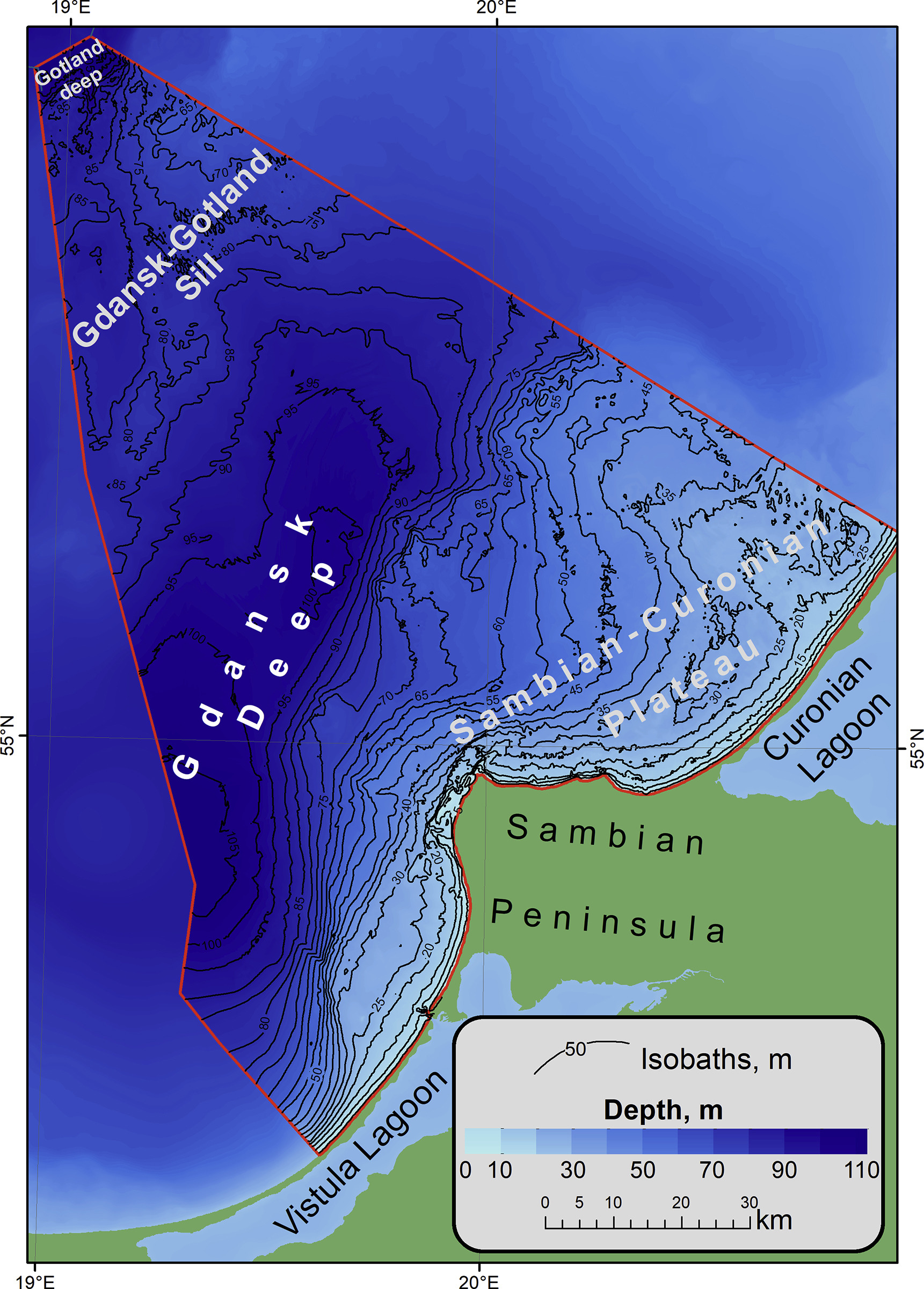
DTM over Kaliningrad area
The bathymetric dataset of a single beam sounding. Surveys were conducted in 25 expeditions of the Atlantic branch of Shirshov Institute of Oceanology RAS in the Russian EEZ area of the southeastern part of the Baltic Sea in the period from 2004 to 2018. Acoustic data were acquired by echo sounders Simrad EA-400SP and Furuno FS-700. The raw sounding data were filtered and corrected by sound velocity values. The dataset is presented as spreadsheets (*.xslx) and GIS point-class shapes (*.shp). The digital elevation model (DEM) of 1: 500 000 scale has been constructed for the entire Russian EEZ on base of the original array of sounding profiles and an open sources bathymetry.
|
|
Citation proposal
P.P.Shirshov Institute of Oceanology, RAS. DTM over Kaliningrad area. https://services.mspdata.eu:/geonetwork/srv/api/records/SDN_CPRD_685_KALDTM |
Simple
- Date ( Creation )
- 2020
- Date ( Revision )
- 2020
- Identifier
- KALDTM
Originator
Atlantic branch of Shirshov Institute of Oceanology, RAS
P.O. Box 33
Helsinki
FI-00521
Russian Federation
Custodian
- Project name ( Theme )
-
- EMODnetHRSM2
- SeaDataNet device categories ( Theme )
-
- plummets , single-beam echosounders
- http://vocab.ndg.nerc.ac.uk/ ( Stratum )
-
- Parameter Discovery Vocabulary (P02) ( parameter )
-
- Bathymetry and Elevation
- GEMET - INSPIRE themes, version 1.0 ( Theme )
-
- Hydrography
- Access constraints
- licence
- Use constraints
- unrestricted
- Spatial representation type
- Grid
- Denominator
- 250000
- Distance
- 50 Metres (m)
- Metadata language
- English
- Character set
- UTF8
- Topic category
-
- Oceans
N
S
E
W
))
- Geographic identifier
- http://vocab.nerc.ac.uk/collection/C19/current/2_1/
- Description
-
Map projection parameters, values and units :
Axes units :
- Unique resource identifier
- Codespace
- EPSG
- Version
- 7.4
- Reference system identifier
- EPSG / UTM34N, WGS84 /
- Number of dimensions
- 3
- Dimension name
- Column
- Dimension name
- Row
- Dimension name
- Time
- Dimension size
- 1
- Cell geometry
- Point
- Transformation parameter availability
- false
- Checkpoint Availability
- false
- Point in Pixel
-
- Center
- Distribution format
-
-
XYZ Ascii
( )
- Specification
- GeoTIFF ( )
-
XYZ Ascii
( )
Distributor
- Transfer size
- 53
- OnLine resource
- Publication
- Hierarchy level
- Dataset
Vertical extent
- Minimum value
- 0
- Maximum value
- 250
Vertical CS
Vertical datum
- Statement
- no information
- Hierarchy level
- Feature
- Dataset
- accuracy
Gridded data positional accuracy
- Name of measure
- horizontal accuracy
- Measure identification
- horizontal accuracy of coordinate
- Measure description
- As the dataset is compiled based on older charted data as well as new single beam surveys it is hard to asses the uncertainty of the positioning.
- Evaluation method description
- No validation done.
Quantitative result
- Value type
- horizontal accuracy
- Value
- 50m
Quantitative attribute accuracy
- Name of measure
- depth
- Measure identification
- depth accuracy
- Measure description
- As the dataset is compiled based on older charted data as well as new single beam surveys it is hard to asses the uncertainty of the depths.
- Evaluation method description
- No validation done
Quantitative result
- Value
- not defined
Conformance result
- Date
- Explanation
- Pass
- false
- Hierarchy level
- Software
- Description
- Other
- software
- Hierarchy level
- Property type
- Description
- parameters of data processing
- Attributes
- Statement
-
See the full Article under https://www.sciencedirect.com/science/article/pii/S2352340919304779
The data is available as attachments to the article.
- Description
-
The data have multiple sources and has been created in 50m resolution.
This is an openaccess article under the CC BY license (http://creativecommons.org/licenses/by/4.0/).
- Hierarchy level
- Dataset
Absolute external positional accuracy
- Name of measure
- emodnet-bathymetry.QI.Horizontal
- Value
- 2 - Between 50 m and 20 m
Absolute external positional accuracy
- Name of measure
- emodnet-bathymetry.QI.Vertical
- Value
- 1 - SBES low frequency, SDB (similar than 2+5%d)
Domain consistency
- Name of measure
- emodnet-bathymetry.QI.Purpose
- Value
- 2 - Bathymetric/morphologic survey
Metadata
- File identifier
- SDN_CPRD_685_KALDTM XML
- Metadata language
- English
- Character set
- UTF8
- Hierarchy level name
- Product record
- Date stamp
- 2020-09-14T16:09:06
- Metadata standard name
- ISO 19115:2003/19139 - EMODNET - BATHYMETRY
- Metadata standard version
- 1.0