Metadata catalogue
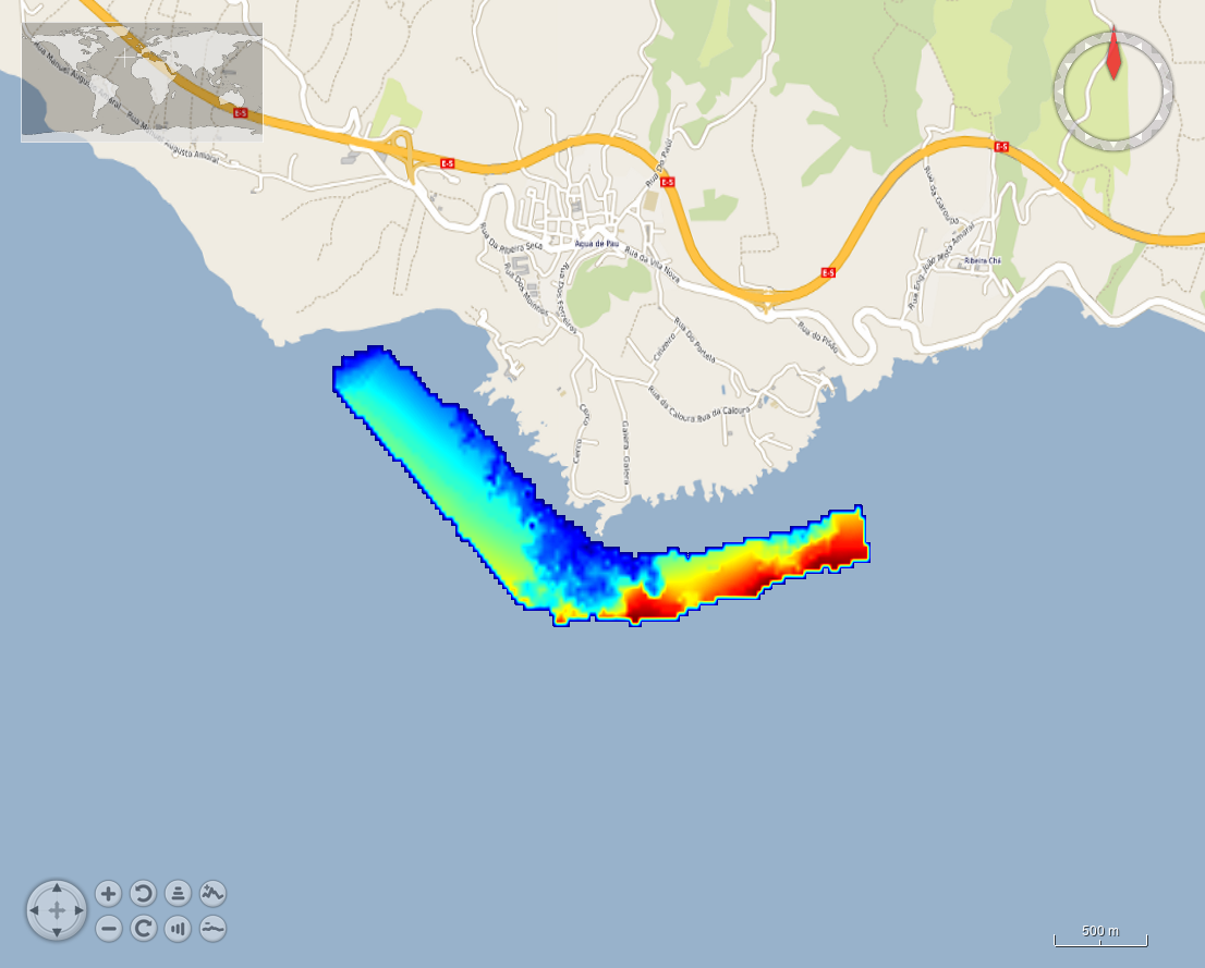
HR_201707_Caloura
Bathymetric data resulting from hydrographic surveys for cartographic purposes and/or port management. Surveys carried out in accordance with the IHO S-44 standard.
|
|
Citation proposal
IHPT, Hydrographic Institute. HR_201707_Caloura. https://services.mspdata.eu:/geonetwork/srv/api/records/SDN_CPRD_590_201707_Caloura |
Simple
- Alternate title
- Date ( Creation )
- 2013
- Date ( Revision )
- 2020
- Identifier
-
201707_Caloura
Custodian
Originator
- Parameter Discovery Vocabulary (P02) ( parameter )
-
-
Bathymetry and Elevation
-
- SeaDataNet device categories ( Theme )
-
-
multi-beam echosounders
-
- Positioning devices ( Theme )
-
-
Differential Global Positioning System receivers
-
- SeaDataNet depth measurement reference planes ( Theme )
-
-
Lowest Astronomical Tide
-
- Project name ( Theme )
-
-
EMODnet HRSM
-
- Thèmes Sextant ( Theme )
-
-
/Physical Environment/Bathymetry/Digital Terrain Model
-
- Use limitation
- Access constraints
- Creative Commons Attribution 4.0 International
- Use constraints
- Other restrictions
- Other constraints
-
DO NOT USE FOR NAVIGATION
- Spatial representation type
- Grid
- Denominator
- 5000
- Distance
- 0.015625 Arc minute
- Metadata language
- English
- Character set
- UTF8
- Topic category
-
- Oceans
Vertical extent
- Minimum value
- 1.11
- Maximum value
- 45.69
- Description
-
Tagus River - Lisbon - Portugal
))
- Reference system identifier
-
EPSG
/WGS 84 (EPSG:4326)
/7.4
- Number of dimensions
- 3
- Dimension name
- Column
- Dimension size
- 193
- Dimension name
- Row
- Dimension size
- 65
- Dimension name
- Time
- Dimension size
- 1
- Cell geometry
- Point
- Transformation parameter availability
- false
- Checkpoint Availability
- false
- Point in Pixel
-
- Lower left
- Distribution format
-
-
XYZ Ascii
()
-
Distributor
Distributor
Distributor
- Transfer size
- 58
- OnLine resource
- EMODnet viewer
- OnLine resource
- EMODnet Bathymetry WMTS service
- OnLine resource
- 201707_Caloura
- Hierarchy level
- Dataset
Conformance result
- Date
- Explanation
- Pass
- false
Quantitative attribute accuracy
- Name of measure
-
depth
- Measure identification
-
depth accuracy
- Measure description
-
According to the S44 (OHI) order of the source
- Evaluation method description
Quantitative result
- Value
- not defined
Gridded data positional accuracy
- Name of measure
-
horizontal accuracy
- Measure identification
-
horizontal accuracy of coordinate
- Measure description
-
According to the S44 (OHI) order of the source
- Evaluation method description
Quantitative result
- Value type
- horizontal accuracy
Absolute external positional accuracy
- Name of measure
-
emodnet-bathymetry.QI.Horizontal
- Value
- 3 < 20 m
Absolute external positional accuracy
- Name of measure
-
emodnet-bathymetry.QI.Vertical
- Value
- 3 - Lidar, SBES high frequency
Domain consistency
- Name of measure
-
emodnet-bathymetry.QI.Purpose
- Value
- 3 - Hydrographic survey or compatible with hydrographic standards
- Hierarchy level
- Software
- Description
- Other
-
software
- Hierarchy level
- Property type
- Description
-
parameters of data processing
- Statement
-
EMODnet processing methodology using Globe software
- Description
-
Data sources: Multibeam Survey (2017)
CDIs: 590_201707_Caloura
Metadata
- File identifier
- SDN_CPRD_590_201707_Caloura XML
- Metadata language
- English
- Character set
- UTF8
- Hierarchy level name
-
Composite Product Record
- Date stamp
- 2025-03-26T11:47:53.443646Z
- Metadata standard name
-
ISO 19115:2003/19139 - EMODNET - BATHYMETRY
- Metadata standard version
-
1.0