 Metadata catalogue
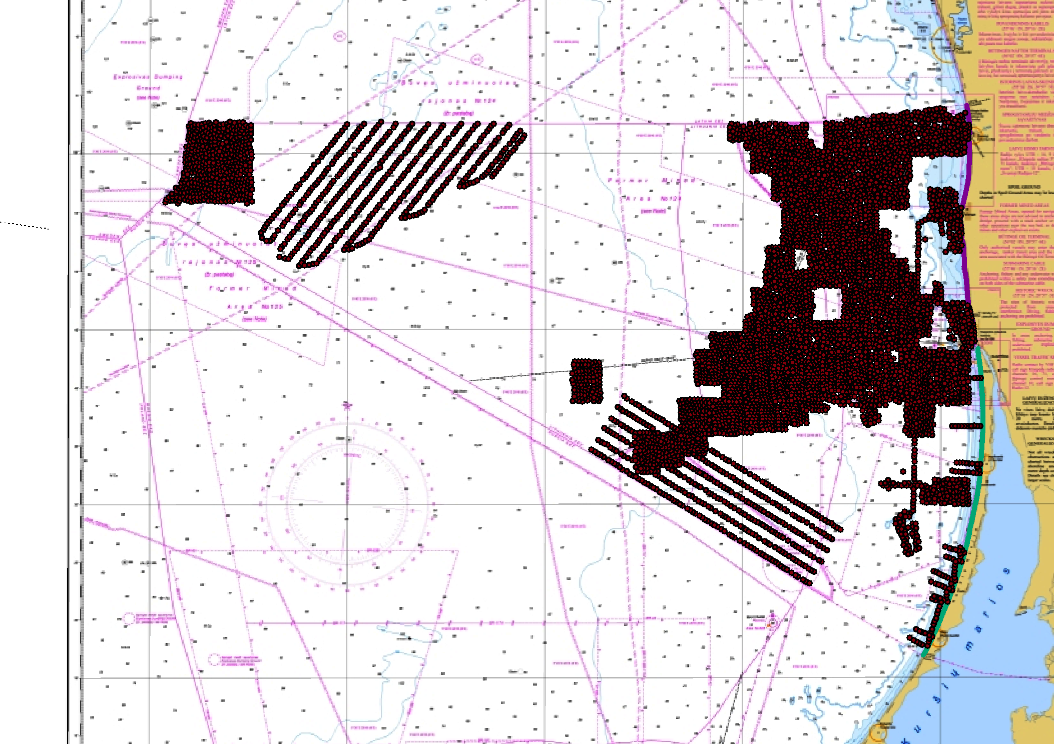
Lithuanian waters, charted soundings
Data extracted from the Lithuanian bathymetric database.
|
|
Citation proposal
Lithuanian Geoportal. Lithuanian waters, charted soundings. https://services.mspdata.eu:/geonetwork/srv/api/records/SDN_CPRD_4720_LITHCHART |
Simple
- Alternate title
-
EMODNET-IFR-WESTMED-2012
- Date ( Creation )
- 2020
- Date ( Revision )
- 2020
- Identifier
-
LITHCHART
Custodian
Originator
- Project name ( Theme )
-
-
EMODnet HRSM
-
- SeaDataNet device categories ( Theme )
-
-
plummets
,multi-beam echosounders
,single-beam echosounders
-
- http://vocab.ndg.nerc.ac.uk/ ( Stratum )
-
- Parameter Discovery Vocabulary (P02) ( parameter )
-
-
Bathymetry and Elevation
-
- GEMET - INSPIRE themes, version 1.0 ( Theme )
-
-
Hydrography
-
- Access constraints
- License
- Use constraints
- Copyright
- Use limitation
-
Data originates from the Lithuanian Hydrographic Office.
- Spatial representation type
- Vector
- Denominator
- 50000
- Distance
- 500 Metres (m)
- Metadata language
- English
- Character set
- UTF8
- Topic category
-
- Oceans
))
- Geographic identifier
- Description
-
Map projection parameters, values and units :
Axes units :
- Unique resource identifier
- Codespace
-
EPSG
- Version
-
7.4
- Reference system identifier
-
EPSG
/WGS 84 (EPSG:4326)
/Elevations are stored in Baltic Sea Chart Datum 2000 (MSL)
- Number of dimensions
- 3
- Dimension name
- Column
- Dimension name
- Row
- Dimension name
- Time
- Dimension size
- 1
- Cell geometry
- Point
- Transformation parameter availability
- false
- Checkpoint Availability
- false
- Point in Pixel
-
- Center
- Distribution format
-
-
ESRI Shapefile
()- Specification
-
Distributor
- Transfer size
- 0.2
- OnLine resource
- https://www.geoportal.lt/geoportal/en/web/en/home
- Hierarchy level
- Dataset
Vertical extent
- Minimum value
- 0
- Maximum value
- 250
Vertical CS
Vertical datum
- Statement
-
no information
- Hierarchy level
- Feature
- Dataset
-
accuracy
Gridded data positional accuracy
- Name of measure
-
horizontal accuracy
- Measure identification
-
horizontal accuracy of coordinate
- Measure description
-
Varying positioning methods has been used and hence it is impossible to set one value of the accuracy. It can vary from <1m to 50m.
- Evaluation method description
-
No validation done.
Quantitative result
- Value type
- horizontal accuracy
- Value
- 50m
Quantitative attribute accuracy
- Name of measure
-
depth
- Measure identification
-
depth accuracy
- Measure description
-
Varying survey methods has been used over the years and hence it is impossible to set one value of the accuracy.
- Evaluation method description
-
No validation done
Quantitative result
- Value
- not defined
Conformance result
- Date
- Explanation
-
Yes for nautical chart production.
- Pass
- true
- Hierarchy level
- Software
- Description
- Other
-
software
- Hierarchy level
- Property type
- Description
-
parameters of data processing
- Attributes
- Statement
-
No interpolation of data.
- Description
-
The data have several sources and has been exported in approximately 500m resolution
- Hierarchy level
- Dataset
Absolute external positional accuracy
- Name of measure
-
emodnet-bathymetry.QI.Horizontal
- Value
- 1 - Between 500m and 50m
Absolute external positional accuracy
- Name of measure
-
emodnet-bathymetry.QI.Vertical
- Value
- 1 - SBES low frequency, SDB (similar than 2+5%d)
Domain consistency
- Name of measure
-
emodnet-bathymetry.QI.Purpose
- Value
- 2 - Bathymetric/morphologic survey
Metadata
- File identifier
- SDN_CPRD_4720_LITHCHART XML
- Metadata language
- English
- Character set
- UTF8
- Hierarchy level name
-
Product record
- Date stamp
- 2020-09-01T17:29:21
- Metadata standard name
-
ISO 19115:2003/19139 - EMODNET - BATHYMETRY
- Metadata standard version
-
1.0
Author
Overviews
Provided by
