Metadata catalogue
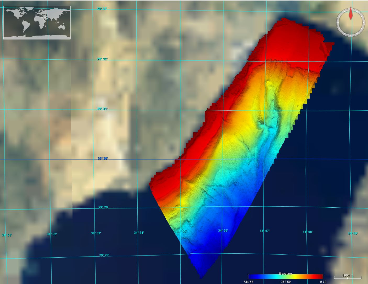
IOLR_DTM_Eilat
Between 29 October and 21 November 2006, as part of the Israel National Bathymetric Survey (NBS), the IOLR’s R/V Etziona carried out a geophysical survey of the Israeli and Jordanian sectors of the northern Red Sea Gulf of ’Aqaba/Elat. Multibeam bathymetric data were collected using a Kongsberg-Simrad EM1002 system with 111 beams operating at 96 kHz. Areas that were not mapped are the northern fish cages,and areas of the coral reef preserves. Project manager: Dr. Gideon Tibor Hydrographer: Ronnie Sade
|
|
Citation proposal
Department of Geology, Geophysics and Coastal Processes, Israel Oceanographic & Limnological Research.. IOLR_DTM_Eilat. https://services.mspdata.eu:/geonetwork/srv/api/records/SDN_CPRD_4671_DTM_Eilat |
Simple
- Alternate title
- Date ( Creation )
- 2006-11-29
- Date ( Revision )
- 2024-01-22
- Identifier
- DTM_Eilat
Originator
Custodian
Department of Geology, Geophysics and Coastal Processes, Israel Oceanographic & Limnological Research.
Tel-Shikmona, POB 8030
Haifa
310801
Israel
Originator
- Website
- web site
- Project name ( Theme )
-
- EMODNet Bathymetry
- SeaDataNet device categories ( Theme )
-
- single-beam echosounders , multi-beam echosounders
- http://vocab.ndg.nerc.ac.uk/ ( Stratum )
-
- Parameter Discovery Vocabulary (P02) ( parameter )
-
- Bathymetry and Elevation
- GEMET - INSPIRE themes, version 1.0 ( Theme )
-
- Hydrography
- SeaDataNet depth measurement reference planes ( Theme )
-
- Use limitation
- Access constraints
- Creative Commons Attribution 4.0 International
- Use constraints
- Other restrictions
- Other constraints
- DO NOT USE FOR NAVIGATION
- Use limitation
- Spatial representation type
- Grid
- Denominator
- 5000
- Distance
- 100 meter
- Metadata language
- English
- Character set
- UTF8
- Topic category
-
- Oceans
N
S
E
W
))
- Unique resource identifier
- Description
-
Map projection parameters, values and units :
Axes units :
- Unique resource identifier
- Codespace
- EPSG
- Version
- 7.4
- Reference system identifier
- EPSG / WGS 84 (EPSG:4326) / 7.4
- Number of dimensions
- 3
- Dimension name
- Column
- Dimension size
- 80
- Dimension name
- Row
- Dimension size
- 100
- Dimension name
- Time
- Dimension size
- 1
- Cell geometry
- Point
- Transformation parameter availability
- false
- Checkpoint Availability
- false
- Point in Pixel
-
- Center
- Distribution format
-
-
XYZ Ascii
( )
- Specification
-
XYZ Ascii
( )
Distributor
Distributor
No information provided.
Distributor
No information provided.
- Protocol
- WWW:LINK
- Name
- Description
- Function
- Information
- Hierarchy level
- Dataset
Vertical extent
- Minimum value
- -5.694
- Maximum value
- -731.682
Vertical CS
Vertical datum
- Statement
- no information
- Hierarchy level
- Feature
- Dataset
- accuracy
Gridded data positional accuracy
- Name of measure
- horizontal accuracy
- Measure identification
- horizontal accuracy of coordinate
- Measure description
- The navigation is all with real-time corrections and is <1 m.
- Evaluation method description
Quantitative result
- Value type
- horizontal accuracy
Quantitative attribute accuracy
- Name of measure
- depth
- Measure identification
- depth accuracy
- Measure description
- Evaluation method description
Quantitative result
- Value
- not defined
Conformance result
- Date
- Explanation
- Hierarchy level
- Software
- Description
- Other
- software
- Hierarchy level
- Property type
- Description
- parameters of data processing
- Attributes
- Statement
- EMODnet processing methodology using Globe software:
- Description
- IOLR_2006_Eilat_GEO
- Hierarchy level
- Dataset
Absolute external positional accuracy
- Name of measure
- emodnet-bathymetry.QI.Horizontal
- Value
- 3 - < 20 m
Absolute external positional accuracy
- Name of measure
- emodnet-bathymetry.QI.Vertical
- Value
- 2 - MBES low frequency (lower than 100kHz) (similar than 1+2%d)
Domain consistency
- Name of measure
- emodnet-bathymetry.QI.Purpose
- Value
- 2 - Bathymetric
Metadata
- File identifier
- SDN_CPRD_4671_DTM_Eilat XML
- Metadata language
- English
- Character set
- UTF8
- Hierarchy level name
- Product record
- Date stamp
- 2024-01-24T11:06:41.049Z
- Metadata standard name
- ISO 19115:2003/19139 - EMODNET - BATHYMETRY
- Metadata standard version
- 1.0