Metadata catalogue
SDN_CPRD_4669_DDM2024_50m
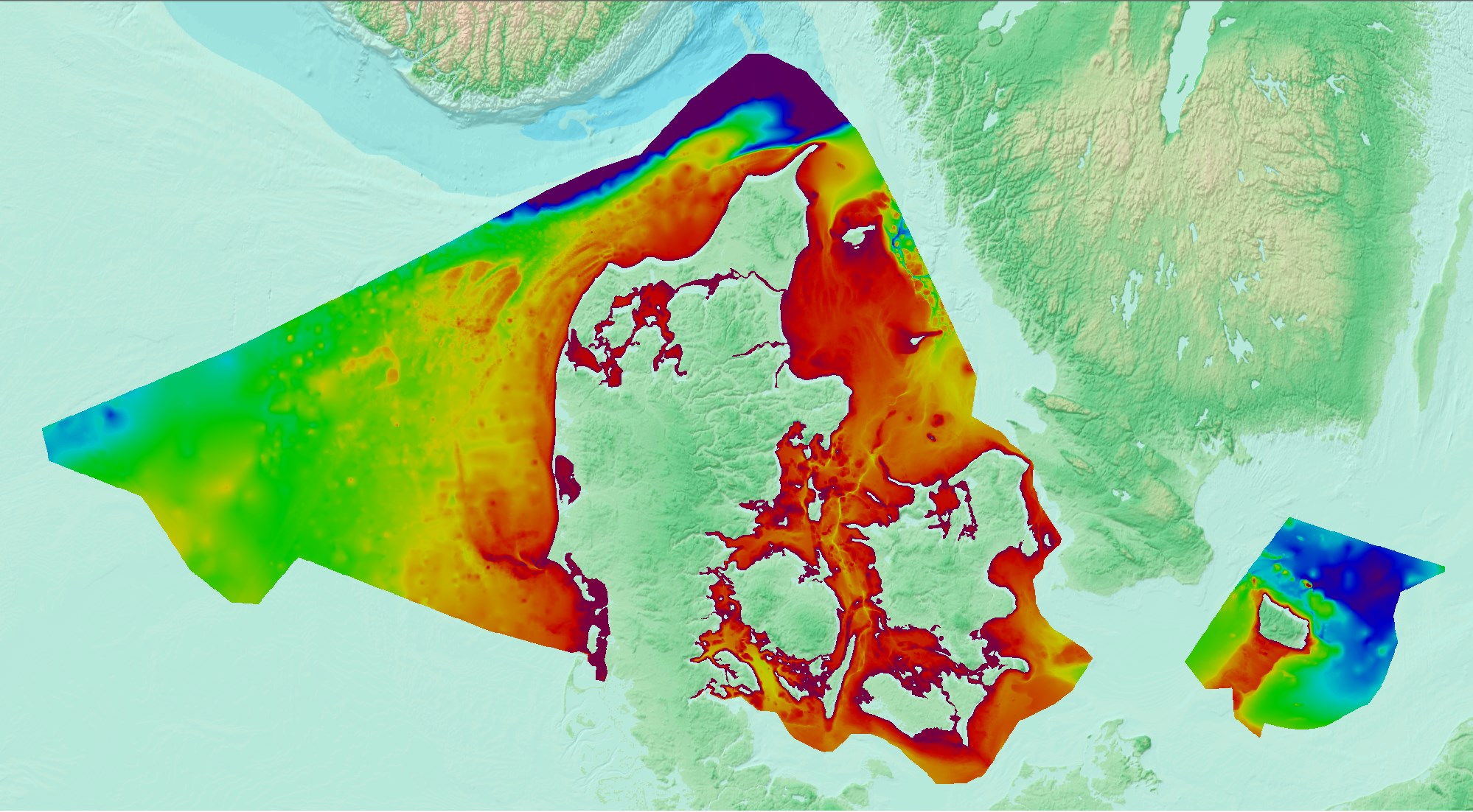
Denmark’s Depth Model (DDM) is a depth-averaged digital bathymetric model, covering Denmark’s Exclusive Economic Zone (EEZ). The model has a grid resolution of 50 meters and is based on a collection of hydrographic survey datasets and other sources.
|
|
Citation proposal
Danish Geodata Agency, Danish Hydrographic Office. SDN_CPRD_4669_DDM2024_50m. https://services.mspdata.eu:/geonetwork/srv/api/records/SDN_CPRD_4669_DDM2024_50m |
Simple
- Alternate title
- Date ( Creation )
- 2024-06-01
- Identifier
- DDM2024_50m
Originator
Custodian
- Website
- web site
- Project name ( Theme )
-
- EMODNet Bathymetry
- SeaDataNet device categories ( Theme )
-
- http://vocab.ndg.nerc.ac.uk/ ( Stratum )
-
- Parameter Discovery Vocabulary (P02) ( parameter )
-
- Bathymetry and Elevation
- GEMET - INSPIRE themes, version 1.0 ( Theme )
-
- Hydrography
- SeaDataNet depth measurement reference planes ( Theme )
-
- mean sea level
- Use limitation
- Not intended for safety of navigation
- Access constraints
- Other restrictions
- Use constraints
- Other restrictions
- Other constraints
- Read more at https://eng.gst.dk/danish-hydrographic-office/denmark-depth-model
- Use limitation
- Not intended for safety of navigation
- Spatial representation type
- Grid
- Denominator
- 1000000
- Distance
- 50 meter
- Metadata language
- English
- Character set
- UTF8
- Topic category
-
- Oceans
N
S
E
W
))
- Geographic identifier
- http://www.naturalearthdata.com/ne_admin#Country/DNK
- Description
-
Map projection parameters, values and units :
Axes units :
- Unique resource identifier
- Codespace
- EPSG
- Version
- 7.4
- Reference system identifier
- EPSG / ETRS89 / LCC Europe (EPSG:3034) /
- Number of dimensions
- 3
- Dimension name
- Column
- Dimension size
- 16133
- Dimension name
- Row
- Dimension size
- 8399
- Dimension name
- Time
- Dimension size
- 1
- Cell geometry
- Point
- Transformation parameter availability
- false
- Checkpoint Availability
- false
- Point in Pixel
-
- Lower left
- Distribution format
-
-
GeoTIFF
(1.0 )
- Specification
-
GeoTIFF
(1.0 )
Distributor
- Website
- web site
Distributor
No information provided.
- Transfer size
- 131
- OnLine resource
-
Dataforsyning
Danish distribution of the model in 50m resolution
- OnLine resource
-
Danish Geodata Agency, homepage
More details about the model
- Hierarchy level
- Dataset
Vertical extent
- Minimum value
- 0
- Maximum value
- 481
Vertical CS
Vertical datum
- Statement
- no information
- Hierarchy level
- Feature
- Dataset
- accuracy
Gridded data positional accuracy
- Name of measure
- horizontal accuracy
- Measure identification
- horizontal accuracy of coordinate
- Measure description
- Varying survey methods has been used over the years and hence it is impossible to set one value of the accuracy.
- Evaluation method description
Quantitative result
- Value type
- horizontal accuracy
Quantitative attribute accuracy
- Name of measure
- depth
- Measure identification
- depth accuracy
- Measure description
- Varying survey methods has been used over the years and hence it is impossible to set one value of the accuracy.
- Evaluation method description
Quantitative result
- Value
- not defined
Conformance result
- Date
- Explanation
- Pass
- false
- Hierarchy level
- Software
- Description
- Other
- software
- Hierarchy level
- Property type
- Description
- parameters of data processing
- Attributes
- Statement
- The model was created using a regularly-spaced grid with the resolution of 50 meters. The horizontal datum of the model is ETRS89 and the coordinates are projected in LCC (EPSG:3034). The vertical datum is Mean Sea Level (MSL) as defined by SDFI’s DKMSL(2022). The extent of the model is constrained between the Danish EEZ and the coastline, generalized at 1:100,000 scale.
- Description
-
The Denmark’s Depth Model (DDM) is a collection of many hydrographic survey datasets and other sources including:
Multibeam echosounder
Singlebeam echosounder
Airborne lidar bathymetry
Satellite derived bathymetry
Crowdsourced bathymetry
Digitized and historical datasets
- Hierarchy level
- Dataset
Absolute external positional accuracy
- Name of measure
- emodnet-bathymetry.QI.Horizontal
- Value
- -1 - Multisources
Absolute external positional accuracy
- Name of measure
- emodnet-bathymetry.QI.Vertical
- Value
- -1 - Multisources
Domain consistency
- Name of measure
- emodnet-bathymetry.QI.Purpose
- Value
- 2 - Bathymetric
Metadata
- File identifier
- SDN_CPRD_4669_DDM2024_50m XML
- Metadata language
- English
- Character set
- UTF8
- Hierarchy level name
- Product record
- Date stamp
- 2025-03-07T14:09:32.854228Z
- Metadata standard name
- ISO 19115:2003/19139 - EMODNET - BATHYMETRY
- Metadata standard version
- 1.0