Metadata catalogue
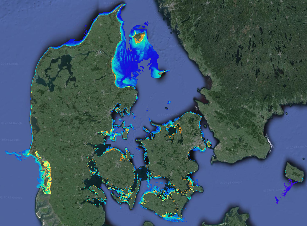
Satellite Derived Bathymetry Denmark EEZ
Data provides Satellite-Derived Bathymetry (SDB) data for shallow waters. The analysis is based on EOMAP’s WATCOR-X SDB software and Sentinel-2 data. The native spatial resolution of the data is 10m.
Supplemental_Information:
EOMAPs Satellite Derived Bathymetry (SDB) method relies on the reflected light energy which is measured at the satellite sensor in space. To calculate water depth, the sea bottom reflection must be separated from all other simultaneously measured portions of light. Other contributors of light scattered to the sensor are atmospheric molecules and aerosols, adjacent scattering from land, the water surface reflection, and light scattered and absorbed due to particular properties of water constituents and the pure water itself. The pure water itself also absorbs light in a spectrally specific manner and therefore leaves unique signatures in the signal while the light passes through the water column and returns after reflection at the sea bottom. This property is relevant to estimate water depth from optical satellite imagery. As many properties can vary over space and time, effective correction, regularization and retrieval algorithms must be applied to avoid instable results. Furthermore, multi-record analytics are part of the process and reduce noise and increase overall vertical accuracies. EOMAP developed and maintains these unique algorithms and its workflows for almost 2 decades and has developed the Watcor-X SDB software. The maximum depth the system is able to sense is related to the complex interaction of radiance of bottom material, incident sun angle and intensity, and the type and quantity of organics or sediments in the water column. As a rule-of-thumb, SDB can measure depths down to one to one point five times the Secchi Disc Depth. The SDB data are compared against Satellite-Lidar Bathymetry (SLB) tracks which have been derived out of the IceSat-2 Atlas instrument and are stored and distributed via EOMAP’s SLB database.
No-data-value optically deep water: -9999
|
|
Citation proposal
EOMAP GmbH & Co KG. Satellite Derived Bathymetry Denmark EEZ. https://services.mspdata.eu:/geonetwork/srv/api/records/SDN_CPRD_4667_denmark2024 |
Simple
- Alternate title
- Date ( Creation )
- 2024-02-29
- Date ( Revision )
- 2024-02-09
- Identifier
-
denmark2024
Originator
- Website
- web site
Custodian
- Website
- web site
- Parameter Discovery Vocabulary (P02) ( parameter )
-
-
Bathymetry and Elevation
-
- SeaDataNet device categories ( Theme )
-
-
cameras
-
- Positioning devices ( Theme )
-
- SeaDataNet depth measurement reference planes ( Theme )
-
-
mean sea level
-
- Project name ( Theme )
-
-
EMODNet Bathymetry
-
- Thèmes Sextant ( Theme )
-
-
/Physical Environment/Bathymetry/Digital Terrain Model
-
- Use limitation
-
see EOMAP EULA: EOMAP_Product_EULA2014Oct19.pdf
- Access constraints
- by negotiation
- Use constraints
- Copyright
- Use limitation
-
surveying, hydrodynamic modelling, pre-planning, coastal zone management
- Spatial representation type
- Grid
- Denominator
- 10000
- Distance
- 10 meter
- Metadata language
- English
- Character set
- UTF8
- Topic category
-
- Oceans
Vertical extent
- Minimum value
- 0
- Maximum value
- -15
- Description
-
Denmark EEZ
))
- Reference system identifier
-
EPSG
/WGS 84 (EPSG:4326)
/8.6
- Reference system identifier
-
EPSG
/WGS 84 (EPSG:4326)
/7.4
- Number of dimensions
- 3
- Dimension name
- Column
- Dimension size
- 48103
- Dimension name
- Row
- Dimension size
- 47245
- Dimension name
- Time
- Dimension size
- 1
- Cell geometry
- Point
- Transformation parameter availability
- false
- Checkpoint Availability
- false
- Point in Pixel
-
- Center
- Distribution format
-
-
GeoTIFF
(1.0
) -
KML
() -
XYZ Ascii
() -
ESRI Shapefile
(1.0
)
-
Distributor
- Transfer size
- 20
- Hierarchy level
- Dataset
Conformance result
- Date
- Explanation
-
No shoal bias
- Pass
- false
Quantitative attribute accuracy
- Name of measure
-
depth
- Measure identification
-
depth accuracy
- Measure description
-
The SDB data are compared against Satellite-Lidar Bathymetry (SLB) tracks which have been derived out of the IceSat-2 Atlas instrument and are stored and distributed via EOMAP’s SLB database. All files meet CAT ZOC C Category or better.
- Evaluation method description
-
LE90
Quantitative result
- Value
- not defined
Gridded data positional accuracy
- Name of measure
-
horizontal accuracy
- Measure identification
-
horizontal accuracy of coordinate
- Measure description
-
Based on global ground control points. Evaluation done by ESA.
- Evaluation method description
-
CE90
Quantitative result
- Value type
- horizontal accuracy
- Value
- 10m
Absolute external positional accuracy
- Name of measure
-
emodnet-bathymetry.QI.Horizontal
- Value
- 3 - < 20 m
Absolute external positional accuracy
- Name of measure
-
emodnet-bathymetry.QI.Vertical
- Value
- 1 - SBES low frequency, SDB (similar than 2+5%d)
Domain consistency
- Name of measure
-
emodnet-bathymetry.QI.Purpose
- Value
- 2 - Bathymetric/morphologic survey
- Hierarchy level
- Software
- Description
- Other
-
software
- Hierarchy level
- Property type
- Description
-
parameters of data processing
- Statement
-
Data were processed by Watcor-X SDB software, by EOMAP GmbH Co.KG.
Watcor-X SDB software is designed for the physically based assessment of hydro-biological parameters from multi- and hyperspectral remote sensing data to quantify water depth. This allows to access bathymetric data, even in the absence of any local survey data..
Correction modules applied:
Corrected for Satellite sensor noise: Yes
Corrected for atmospheric effects: Yes
Corrected for the effect of adjacent land reflectance: Yes
Corrected for effects of turbidity: Yes
Corrected for water refraction effect: No
Ground-control points accessed to improve horizontal accuracy: No
Local in-situ data accessed for calibration and validation purposes: Comparison with IceSat-2 Atlas derived Satellite-Lidar Bathymetric data.
Description of in-situ data used: None
Corrected for tidal influence: Yes (using predicted tidal station(s))
Metadata
- File identifier
- SDN_CPRD_4667_denmark2024 XML
- Metadata language
- English
- Character set
- UTF8
- Hierarchy level name
-
Composite Product Record
- Date stamp
- 2024-03-14T13:23:57.672Z
- Metadata standard name
-
ISO 19115:2003/19139 - EMODNET - BATHYMETRY
- Metadata standard version
-
1.0
Author
- Website
- web site