Metadata catalogue
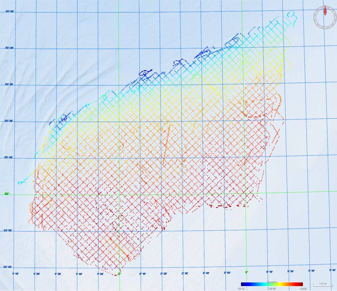
Site survey of Dogger Bank Tranche A development area by GEMS Survey Ltd
GEMS Survey Ltd. (GEMS) were contracted by Forewind Limited to undertake a bathymetric and geophysical survey of the Tranche A development area and two met mast locations (which were later revised) within the Dogger Bank Zone, in addition to a cable reconnaissance from Tranche A to the Yorkshire coastline. The primary objectives of the survey were to produce sufficiently high resolution bathymetric and geophysical data and interpretations to allow regional interpretation for planning and modelling purposes; for met mast design to commence and to provide high quality data to inform further benthic and environmental surveys. This survey was carried out between 8 July 2010 and 26 December 2010. The vertical datum for this project is LAT using predicted tides. This metadata relates to the bathymetric datasets. The surveys were undertaken onboard the MV Aquarius and MV Kommandor Jack.
|
|
Citation proposal
British Oceanographic Data Centre. Site survey of Dogger Bank Tranche A development area by GEMS Survey Ltd. https://services.mspdata.eu:/geonetwork/srv/api/records/SDN_CPRD_43_8424_5m_dtm |
Simple
- Alternate title
- Date ( Creation )
- 2024-05-29
- Date ( Revision )
- Identifier
-
8424_5m_dtm
Originator
Custodian
Joseph Proudman Building
6 Brownlow Street
Liverpool
L3 5DA
United Kingdom
- Website
- web site
- Project name ( Theme )
-
-
EMODNet Bathymetry
-
- SeaDataNet device categories ( Theme )
-
-
multi-beam echosounders
-
- http://vocab.ndg.nerc.ac.uk/ ( Stratum )
-
- Parameter Discovery Vocabulary (P02) ( parameter )
-
-
Bathymetry and Elevation
-
- GEMET - INSPIRE themes, version 1.0 ( Theme )
-
-
Hydrography
-
- SeaDataNet depth measurement reference planes ( Theme )
-
- Use limitation
- Access constraints
- unrestricted
- Use constraints
- Creative Commons Attribution 4.0 International
- Other constraints
- Use limitation
- Spatial representation type
- Grid
- Denominator
- 10000
- Distance
- 25 meter
- Metadata language
- English
- Character set
- UTF8
- Topic category
-
- Oceans
))
- Geographic identifier
- Description
-
Map projection parameters, values and units :
Axes units :
- Unique resource identifier
- Codespace
-
EPSG
- Version
-
7.4
- Reference system identifier
-
EPSG
/WGS 84 (EPSG:4326)
/7.4
- Number of dimensions
- 3
- Dimension name
- Column
- Dimension size
- 5726
- Dimension name
- Row
- Dimension size
- 5312
- Dimension name
- Time
- Dimension size
- 1
- Resolution
- 5 month
- Cell geometry
- Point
- Transformation parameter availability
- false
- Checkpoint Availability
- false
- Point in Pixel
-
- Center
- Distribution format
-
-
XYZ Ascii
()- Specification
-
Distributor
Joseph Proudman Building
6 Brownlow Street
Liverpool
L3 5DA
United Kingdom
- Website
- web site
- Transfer size
- 1110
- OnLine resource
- Original data and metadata - Marine Data Exchange
- OnLine resource
- EMODnet Bathymetry WMTS service
- Hierarchy level
- Dataset
Vertical extent
- Minimum value
- 19.38
- Maximum value
- 77.77
Vertical CS
Vertical datum
- Statement
-
no information
- Hierarchy level
- Feature
- Dataset
-
accuracy
Gridded data positional accuracy
- Name of measure
-
horizontal accuracy
- Measure identification
-
horizontal accuracy of coordinate
- Measure description
- Evaluation method description
Quantitative result
- Value type
- horizontal accuracy
Quantitative attribute accuracy
- Name of measure
-
depth
- Measure identification
-
depth accuracy
- Measure description
- Evaluation method description
Quantitative result
- Value
- not defined
Conformance result
- Date
- Explanation
- Pass
- false
- Hierarchy level
- Software
- Description
- Other
-
software
- Hierarchy level
- Property type
- Description
-
parameters of data processing
- Attributes
- Statement
-
Description of data processing : This bathymetric data was collected using SEA SWATHplus and R2 Sonic 2024 systems and processed using QINSy and Fledermaus. It was delivered to Forewind in the following formats. XYZ (.xyz), Flederrmaus (.sd), TIFF (.tif), Google Earth (.kmz), ASCII (.asc), ArcGIS (.shp). A 5m DTM file was prodiced and made available to the British Oceanographic Data Centre (BODC). The 5m DTM file was then converted by BODC using Globe software (v2.5.2) to the EMODnet Bathymetry standard DTM.NC format at 25m resolution.
- Description
-
Description of processed data sources : The bathymetric survey data from both vessels were acquired using using SEA SWATHplus (177Hz) and R2 Sonic 2024 systems.
- Hierarchy level
- Dataset
Absolute external positional accuracy
- Name of measure
-
emodnet-bathymetry.QI.Horizontal
- Value
- 3 - < 20 m
Absolute external positional accuracy
- Name of measure
-
emodnet-bathymetry.QI.Vertical
- Value
- 4 - MBES High frequency (higher that 100kHz) (1+0.5%d)
Domain consistency
- Name of measure
-
emodnet-bathymetry.QI.Purpose
- Value
- 2 - Bathymetric/morphologic survey
Metadata
- File identifier
- SDN_CPRD_43_8424_5m_dtm XML
- Metadata language
- English
- Character set
- UTF8
- Hierarchy level name
-
Product record
- Date stamp
- 2025-03-07T15:17:10.210908Z
- Metadata standard name
-
ISO 19115:2003/19139 - EMODNET - BATHYMETRY
- Metadata standard version
-
1.0
Author
Joseph Proudman Building
6 Brownlow Street
Liverpool
L3 5DA
United Kingdom
- Website
- web site