Metadata catalogue
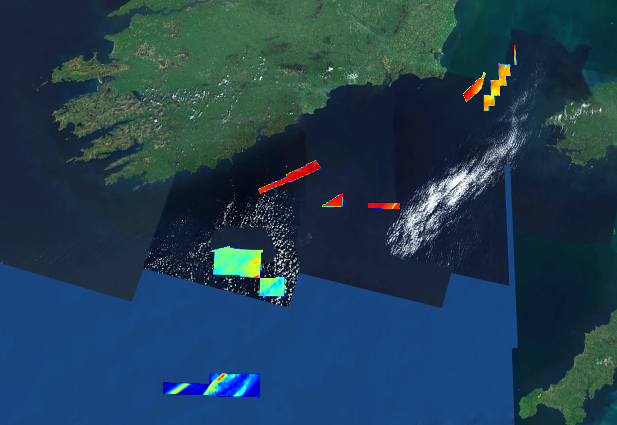
366_HRDTM_29m_CelticSea
This composite Digital Terrain Model (cDTM) is a high resolution bathymetry dataset highlighting measurement of depth of water in the ocean. This cDTM covers the Celtic Sea off the coast of counties Cork, Waterford and Wexford in Ireland. The EMODnet high resolution DTM covers bathymetry surveys completed between 2002 and 2016. Bathymetric data collected on board research vessels using multi-beam and single-beam echosounder instrumentation. Raw bathymetry processed within CARIS software to produce bathymetry products subsequently converted to NetCDF cDTM for EMODnet. Acquisition, processing and product delivery follows IHO standard s44 Edition 5. cDTM is composed of four (4) images “merged simply” using GLOBE software. INFOMAR (Integrated Mapping for the Sustainable Development of Ireland’s Marine Resource) is a twenty year programme to map the physical, chemical and biological features of Ireland’s seabed established in 2006. INFOMAR is funded by the Department of Communications, Climate Action and Environment (DCCAE), and delivered by joint management partners Geological Survey Ireland and the Marine Institute. The programme is the successor to the Irish National Seabed Survey (INSS) which ran between 1999 and 2005. INFOMAR concentrates on creating integrated mapping products related to the seabed.
|
|
Citation proposal
Geological Survey Ireland. 366_HRDTM_29m_CelticSea. https://services.mspdata.eu:/geonetwork/srv/api/records/SDN_CPRD_366_HRDTM_29m_CelticSea |
Simple
- Alternate title
- Date ( Creation )
- 2019-12-17
- Date ( Revision )
- Identifier
- HRDTM_29m_CelticSea
Originator
Custodian
- Parameter Discovery Vocabulary (P02) ( parameter )
-
- Date and time , Bathymetry and Elevation
- SeaDataNet device categories ( Theme )
-
- multi-beam echosounders
- Positioning devices ( Theme )
-
- Differential Global Positioning System receivers
- SeaDataNet depth measurement reference planes ( Theme )
-
- Lowest Astronomical Tide
- Project name ( Theme )
-
- EMODnet HRSM
- Thèmes Sextant ( Theme )
-
- /Physical Environment/Bathymetry/Digital Terrain Model
- GEMET - INSPIRE themes, version 1.0 ( Theme )
-
- Elevation
- Use limitation
- Access constraints
- Creative Commons Attribution 4.0 International
- Use constraints
- Other restrictions
- Other constraints
- DO NOT USE FOR NAVIGATION
- Spatial representation type
- Grid
- Denominator
- 10000
- Distance
- 0.015625 Arc minute
- Metadata language
- English
- Character set
- UTF8
- Topic category
-
- Oceans
Vertical extent
- Minimum value
- -134
- Maximum value
- -76
- Description
N
S
E
W
))
- Reference system identifier
- WGS 84 (EPSG:4326) / 7.4
- Number of dimensions
- 3
- Dimension name
- Column
- Dimension size
- 13696
- Dimension name
- Row
- Dimension size
- 8640
- Dimension name
- Time
- Dimension size
- 1
- Cell geometry
- Point
- Transformation parameter availability
- false
- Checkpoint Availability
- false
- Point in Pixel
-
- Center
- Distribution format
-
- NetCDF ( )
Distributor
- Transfer size
- 1760
- OnLine resource
- EMODnet Bathymetry WMTS service
- OnLine resource
- EMODnet viewer
- OnLine resource
-
366_HRDTM_29m_CelticSea - Format EMO
366_HRDTM_29m_CelticSea - Format EMO
- Hierarchy level
- Dataset
Conformance result
- Date
- Explanation
- Pass
- false
Quantitative attribute accuracy
- Name of measure
- depth
- Measure identification
- depth accuracy
- Measure description
- Evaluation method description
Quantitative result
- Value
- not defined
Gridded data positional accuracy
- Name of measure
- horizontal accuracy
- Measure identification
- horizontal accuracy of coordinate
- Measure description
- Evaluation method description
Quantitative result
- Value type
- horizontal accuracy
Absolute external positional accuracy
- Name of measure
- emodnet-bathymetry.QI.Horizontal
- Value
- 3 - < 20 m
Absolute external positional accuracy
- Name of measure
- emodnet-bathymetry.QI.Vertical
- Value
- 4 - MBES High frequency (higher that 100kHz) (1+0.5%d)
Domain consistency
- Name of measure
- emodnet-bathymetry.QI.Purpose
- Value
- 3 - Hydrographic survey or compatible with hydrographic standards
- Hierarchy level
- Software
- Description
- Other
- software
- Hierarchy level
- Property type
- Description
- parameters of data processing
- Other
- data processing details
- Statement
- Raw bathymetry processed within CARIS software to produce bathymetry products subsequently converted to NetCDF cDTM for EMODnet.
- Description
- Relevant CDI IDs: 2869798, 2869799, 2869788, 2869810
Metadata
- File identifier
- SDN_CPRD_366_HRDTM_29m_CelticSea XML
- Metadata language
- English
- Character set
- UTF8
- Hierarchy level
- Dataset
- Hierarchy level name
- Composite Product Record
- Date stamp
- 2023-01-26T14:38:43.561Z
- Metadata standard name
- ISO 19115:2003/19139 - EMODNET - BATHYMETRY
- Metadata standard version
- 1.0