 Metadata catalogue
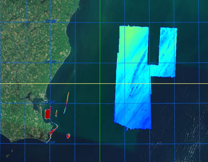
Tuskar Rock Wexford Surveys
|
|
Citation proposal
Geological Survey Ireland. Tuskar Rock Wexford Surveys. https://services.mspdata.eu:/geonetwork/srv/api/records/SDN_CPRD_366_14mIrishSeaSouthWexfordTuskar |
Simple
- Alternate title
- Date ( Creation )
- 2022-09-26
- Date ( Revision )
- 2022-10-06
- Identifier
- 14mIrishSeaSouthWexfordTuskar
Originator
Custodian
- Project name ( Theme )
-
- EMODNet Bathymetry
- SeaDataNet device categories ( Theme )
-
- multi-beam echosounders , single-beam echosounders
- http://vocab.ndg.nerc.ac.uk/ ( Stratum )
-
- Parameter Discovery Vocabulary (P02) ( parameter )
-
- Bathymetry and Elevation
- GEMET - INSPIRE themes, version 1.0 ( Theme )
-
- Hydrography
- SeaDataNet depth measurement reference planes ( Theme )
-
- Use limitation
- Access constraints
- Creative Commons Attribution 4.0 International
- Use constraints
- Other restrictions
- Other constraints
-
DO NOT USE FOR NAVIGATION
Please use this specific attribution statement: "Contains Irish Public Sector Data (Geological Survey Ireland & Marine Institute) licensed under a Creative Commons Attribution 4.0 International (CC BY 4.0) licence".
In cases where it is not practical to use the statement users may include a URI or hyperlink to a resource that contains the required attribution statement.
- Use limitation
- maritime navigation; maritime spatial planning; renewable energy
- Spatial representation type
- Grid
- Denominator
- 100000
- Distance
- 14 Metres (m)
- Metadata language
- English
- Character set
- UTF8
- Topic category
-
- Oceans
))
- Geographic identifier
- Saint George's Channel Wexford
- Description
-
Map projection parameters, values and units :
Axes units :
- Unique resource identifier
- Codespace
- EPSG
- Version
- 7.4
- Reference system identifier
- EPSG / WGS 84 (EPSG:4326) / 7.4
- Number of dimensions
- 3
- Dimension name
- Column
- Dimension size
- 3840
- Dimension name
- Row
- Dimension size
- 7040
- Dimension name
- Time
- Dimension size
- 1
- Cell geometry
- Point
- Transformation parameter availability
- false
- Checkpoint Availability
- false
- Point in Pixel
-
- Lower left
- Distribution format
-
-
NetCDF
(4.0 )
- Specification
-
NetCDF
(4.0 )
Distributor
- Transfer size
- 425
- OnLine resource
- EMODnet Bathymetry WMTS service
- OnLine resource
- EMODnet viewer
- OnLine resource
-
14m_Irish_Sea_South_Wexford_Tuskar - Format EMO
14m_Irish_Sea_South_Wexford_Tuskar - Format EMO
- Hierarchy level
- Dataset
Vertical extent
- Minimum value
- 2.299
- Maximum value
- 119.69
Vertical CS
Vertical datum
- Statement
- no information
- Hierarchy level
- Feature
- Dataset
- accuracy
Gridded data positional accuracy
- Name of measure
- horizontal accuracy
- Measure identification
- horizontal accuracy of coordinate
- Measure description
- Total Horizontal Uncertainty (THU)
- Evaluation method description
- Component of total propagated uncertainty (TPU) calculated in the horizontal dimension. THU is a two-dimensional quantity with all contributing horizontal measurement uncertainties included.
Quantitative result
- Value type
- horizontal accuracy
- Value
- Internatonal Hydrographic Organization Standards for Hydrographic Surveys
Quantitative attribute accuracy
- Name of measure
- depth
- Measure identification
- depth accuracy
- Measure description
- Total Vertical Uncertainty (TVU)
- Evaluation method description
- Component of total propagated uncertainty (TPU) calculated in the vertical dimension. TVU is a one-dimensional quantity with all contributing vertical measurement uncertainties included.
Quantitative result
- Value
- not defined
Conformance result
- Date
- Explanation
- Hierarchy level
- Software
- Description
- Other
- software
- Hierarchy level
- Property type
- Description
- parameters of data processing
- Attributes
- Statement
- Convert 5m XYZ to 7m and 14m DTM using GLOBE. Simply merge DTM's to compoiste cDTM grid for publication
- Description
-
CV_02_SCALP_TUSKAR_14M_WGS84
CV_06_02_ADFISH_WX_5M_WGS84
KY_15_03_Wexford_7m_WGS84
- Hierarchy level
- Dataset
Absolute external positional accuracy
- Name of measure
- emodnet-bathymetry.QI.Horizontal
- Value
- 3 - < 20 m
Absolute external positional accuracy
- Name of measure
- emodnet-bathymetry.QI.Vertical
- Value
- 4 - MBES High frequency (higher that 100kHz) (1+0.5%d)
Domain consistency
- Name of measure
- emodnet-bathymetry.QI.Purpose
- Value
- 3 - Hydrographic survey or compatible with hydrographic standards
Metadata
- File identifier
- SDN_CPRD_366_14mIrishSeaSouthWexfordTuskar XML
- Metadata language
- English
- Character set
- UTF8
- Hierarchy level name
- Product record
- Date stamp
- 2023-01-26T15:19:06.6Z
- Metadata standard name
- ISO 19115:2003/19139 - EMODNET - BATHYMETRY
- Metadata standard version
- 1.0
Author
Overviews
Provided by
