Metadata catalogue
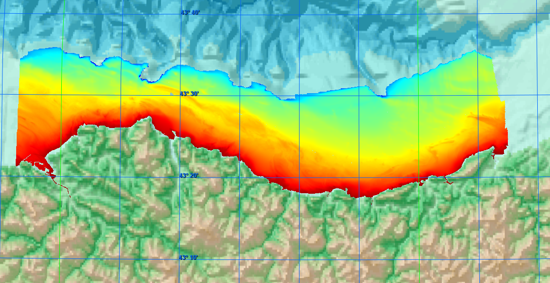
DTM1 of Cantabrian Sea continental shelf.
DTM with bathymetry data of continental shelf of Cantabrian Sea, with deep between 2 and 284 meters.
|
|
Citation proposal
IEO-CSIC, Spanish Oceanographic Institute. DTM1 of Cantabrian Sea continental shelf.. https://services.mspdata.eu:/geonetwork/srv/api/records/SDN_CPRD_353_29VE201702080DTM01 |
Simple
- Alternate title
- Date ( Creation )
- 2024-02-01
- Date ( Revision )
- 2024-12-01
- Identifier
- 29VE201702080DTM01
Originator
Custodian
- Project name ( Theme )
-
- EMODNet Bathymetry
- SeaDataNet device categories ( Theme )
-
- multi-beam echosounders , single-beam echosounders
- http://vocab.ndg.nerc.ac.uk/ ( Stratum )
-
- Parameter Discovery Vocabulary (P02) ( parameter )
-
- Bathymetry and Elevation
- GEMET - INSPIRE themes, version 1.0 ( Theme )
-
- Hydrography
- SeaDataNet depth measurement reference planes ( Theme )
-
- Use limitation
- Not for Navigation
- Access constraints
- unrestricted
- Use constraints
- Copyright
- Other constraints
-
EMODnet Bathymetry consortium (2024), EMODnet Digital
High Resolution DTM
- Use limitation
- Not for navigation
- Spatial representation type
- Grid
- Denominator
- 50000
- Distance
- 115 meter
- Metadata language
- English
- Character set
- UTF8
- Topic category
-
- Oceans
N
S
E
W
))
- Unique resource identifier
- Description
-
Map projection parameters, values and units :
Axes units :
- Unique resource identifier
- Codespace
- EPSG
- Version
- 7.4
- Reference system identifier
- EPSG / WGS 84 (EPSG:4326) / 7.4
- Number of dimensions
- 3
- Dimension name
- Column
- Dimension size
- 1360
- Dimension name
- Row
- Dimension size
- 336
- Dimension name
- Time
- Dimension size
- 1
- Resolution
- 1 year
- Cell geometry
- Point
- Transformation parameter availability
- false
- Checkpoint Availability
- false
- Point in Pixel
-
- Lower right
- Distribution format
-
-
XYZ Ascii
( )
- Specification
-
XYZ Ascii
( )
Distributor
- Transfer size
- 1
- Protocol
- WWW:LINK
- Name
- Description
- Function
- Information
- OnLine resource
- EMODnet Bathymetry WMTS service
- Hierarchy level
- Dataset
Vertical extent
- Minimum value
- 2
- Maximum value
- 284
Vertical CS
Vertical datum
- Statement
- no information
- Hierarchy level
- Feature
- Dataset
- accuracy
Gridded data positional accuracy
- Name of measure
- horizontal accuracy
- Measure identification
- horizontal accuracy of coordinate
- Measure description
- horizontal accuracy of coordinate
- Evaluation method description
- Depends on the sources of data, in this case DGPS.
Quantitative result
- Value type
- horizontal accuracy
Quantitative attribute accuracy
- Name of measure
- depth
- Measure identification
- depth accuracy
- Measure description
- Evaluation method description
Quantitative result
- Value
- not defined
Conformance result
- Date
- Explanation
- Offset of 2m
- Pass
- true
- Hierarchy level
- Software
- Description
- Other
- software
- Hierarchy level
- Property type
- Description
- parameters of data processing
- Attributes
- Statement
- Description of data processing :The information was processed using ARCGIS software to create a DTM with a resolution of 100 meters x 100 meters. The source data are multibeam data from several surveys.
- Description
- Description of processed data sources : Data sources were acquired with a multibeam echosounder and processed with Caris Hips & Sips to filter the data and correct wave-related errors such as pitch and roll. The surveys were INDEMARES-AVILES in the framework of INDEMARES project.
- Hierarchy level
- Dataset
Absolute external positional accuracy
- Name of measure
- emodnet-bathymetry.QI.Horizontal
- Value
- 1 - Between 500m and 50m
Absolute external positional accuracy
- Name of measure
- emodnet-bathymetry.QI.Vertical
- Value
- 2 - MBES low frequency (lower than 100kHz) (similar than 1+2%d)
Domain consistency
- Name of measure
- emodnet-bathymetry.QI.Purpose
- Value
- 2 - Bathymetric/morphologic survey
Metadata
- File identifier
- SDN_CPRD_353_29VE201702080DTM01 XML
- Metadata language
- English
- Character set
- UTF8
- Hierarchy level name
- Product record
- Date stamp
- 2025-01-17T13:03:53.127144Z
- Metadata standard name
- ISO 19115:2003/19139 - EMODNET - BATHYMETRY
- Metadata standard version
- 1.0