Metadata catalogue
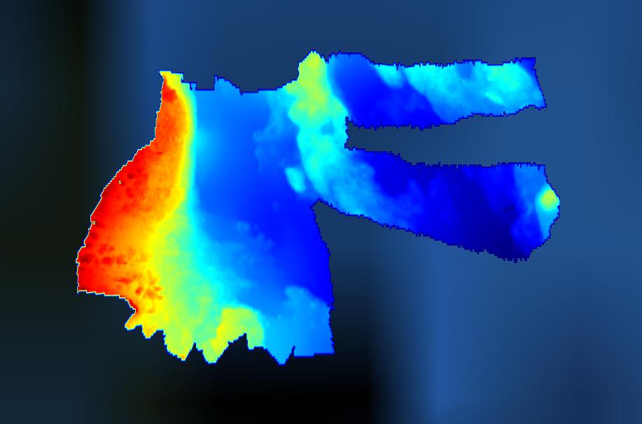
3289_ESTUNLAR_Nolsoy_2015
Multibeam bathymetry east of Nólsoy village, Faroe Islands.
|
|
Citation proposal
Jardfeingi, the Faroe Islands Earth and Energy Directorate. 3289_ESTUNLAR_Nolsoy_2015. https://services.mspdata.eu:/geonetwork/srv/api/records/SDN_CPRD_3289_FO_NOL_2015 |
Simple
- Alternate title
- Date ( Creation )
- 2010-06-03
- Date ( Revision )
- 2010-06-03
- Identifier
- FO_NOL_2015
Originator
Jardfeingi, the Faroe Islands Earth and Energy Directorate
Brekkutún 1
Postsmoga 3059
Tórshavn FO 110 Faroe IslandsCustodian
Jardfeingi, the Faroe Islands Earth and Energy Directorate
Brekkutún 1
Postsmoga 3059
Tórshavn FO 110 Faroe Islands- Parameter Discovery Vocabulary (P02) ( parameter )
-
- Bathymetry and Elevation
- SeaDataNet device categories ( Theme )
-
- multi-beam echosounders
- Positioning devices ( Theme )
-
- Differential Global Positioning System receivers
- Vertical Datum ( Theme )
-
- local reference plane
- Project name ( Theme )
-
- EMODnet HRSM
- Thèmes Sextant ( Theme )
-
- /Physical Environment/Bathymetry/Digital Terrain Model
- Use limitation
- Access constraints
- Creative Commons Attribution 4.0 International
- Use constraints
- Other restrictions
- Other constraints
- DO NOT USE FOR NAVIGATION
- Spatial representation type
- Grid
- Denominator
- 5000
- Distance
- 0.00390625 Arc minute
- Metadata language
- English
- Character set
- UTF8
- Topic category
-
- Oceans
Vertical extent
- Minimum value
- 2.85
- Maximum value
- 44.3
- Description
N
S
E
W
))
- Number of dimensions
- 3
- Dimension name
- Column
- Dimension size
- 768
- Dimension name
- Row
- Dimension size
- 256
- Dimension name
- Time
- Dimension size
- 1
- Cell geometry
- Point
- Transformation parameter availability
- false
- Checkpoint Availability
- false
- Point in Pixel
-
- Center
- Distribution format
-
- XYZ Ascii (1.0 )
- Transfer size
- 78
- OnLine resource
-
FO_NOL_2015 - Format EMO
FO_NOL_2015 - Format EMO
- OnLine resource
- EMODnet Bathymetry WMTS service
- OnLine resource
- EMODnet viewer
- Hierarchy level
- Dataset
Conformance result
- Date
- Explanation
- Pass
- false
Quantitative attribute accuracy
- Name of measure
- depth
- Measure identification
- depth accuracy
- Measure description
- Evaluation method description
Quantitative result
- Value
- not defined
Gridded data positional accuracy
- Name of measure
- horizontal accuracy
- Measure identification
- horizontal accuracy of coordinate
- Measure description
- Evaluation method description
Quantitative result
- Value type
- horizontal accuracy
Absolute external positional accuracy
- Name of measure
- emodnet-bathymetry.QI.Horizontal
- Value
- 3 - < 20 m
Absolute external positional accuracy
- Name of measure
- emodnet-bathymetry.QI.Vertical
- Value
- 4 - MBES High frequency (higher that 100kHz) (1+0.5%d)
Domain consistency
- Name of measure
- emodnet-bathymetry.QI.Purpose
- Value
- 2 - Bathymetric/morphologic survey
- Hierarchy level
- Software
- Description
- Other
- software
- Hierarchy level
- Property type
- Description
- parameters of data processing
Metadata
- File identifier
- SDN_CPRD_3289_FO_NOL_2015 XML
- Metadata language
- English
- Character set
- UTF8
- Hierarchy level name
- Composite Product Record
- Date stamp
- 2025-03-07T14:09:20.200372Z
- Metadata standard name
- ISO 19115:2003/19139 - EMODNET - BATHYMETRY
- Metadata standard version
- 1.0