Metadata catalogue
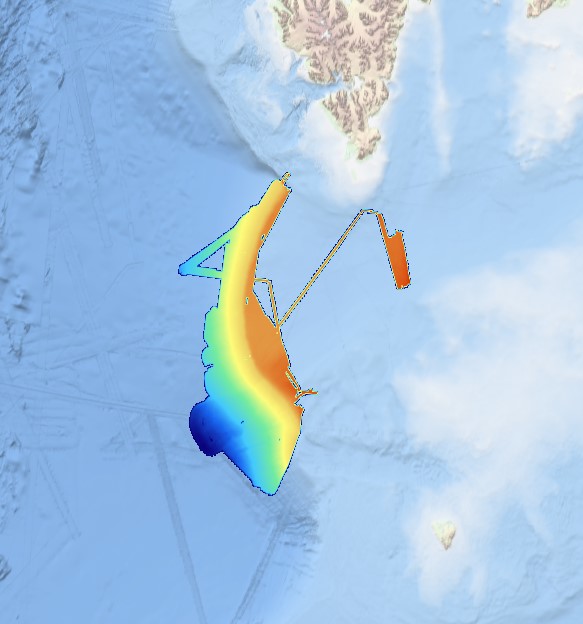
280_181030-HRDTM-SVAIS-60m
Multibeam data acquired in 2007 during the SVAIS cruise on board the R/VHespérides with a Simrad EM12 echo-sounder
|
|
Citation proposal
ICM-CSIC/ Institute of Marine Sciences. 280_181030-HRDTM-SVAIS-60m. https://services.mspdata.eu:/geonetwork/srv/api/records/SDN_CPRD_280_181030-SVAIS |
Simple
- Alternate title
- Date ( Creation )
- 2018-10-22
- Date ( Revision )
- 2018-10-22
- Identifier
-
181030-SVAIS
Originator
Paseo Marítimo de la Barceloneta, 37-49
Barcelona
08003
Spain
Point of contact
Point of contact
Custodian
Paseo Marítimo de la Barceloneta, 37-49
Barcelona
08003
Spain
- Parameter Discovery Vocabulary (P02) ( parameter )
-
-
Bathymetry and Elevation
-
- SeaDataNet device categories ( Theme )
-
-
multi-beam echosounders
-
- Positioning devices ( Theme )
-
-
Differential Global Positioning System receivers
-
- Vertical Datum ( Theme )
-
-
Lowest Astronomical Tide
-
- Project name ( Theme )
-
-
EMODnet HRSM
-
- Thèmes Sextant ( Theme )
-
-
/Physical Environment/Bathymetry/Digital Terrain Model
-
- Use limitation
-
Not for navigation
- Access constraints
- unrestricted
- Use constraints
- Copyright
- Other constraints
-
EMODnet Bathymetry consortium (2018), EMODnet Digital High Resolution DTM
- Use limitation
-
Not for navigation
- Spatial representation type
- Grid
- Denominator
- 10000
- Distance
- 0.03125 Arc minute
- Metadata language
- English
- Character set
- UTF8
- Topic category
-
- Oceans
Vertical extent
- Minimum value
- 56.76
- Maximum value
- 2454.14
- Description
))
- Reference system identifier
-
WGS-84
/
- Reference system identifier
-
EPSG
/WGS 84 (EPSG:4326)
/7.4
- Number of dimensions
- 3
- Dimension name
- Column
- Dimension size
- 10688
- Dimension name
- Row
- Dimension size
- 3610
- Dimension name
- Time
- Dimension size
- 1
- Cell geometry
- Point
- Transformation parameter availability
- false
- Checkpoint Availability
- false
- Point in Pixel
-
- Upper left
- Hierarchy level
- Dataset
Conformance result
- Date
- Explanation
- Pass
- false
Quantitative attribute accuracy
- Name of measure
-
depth
- Measure identification
-
depth accuracy
- Measure description
- Evaluation method description
Quantitative result
- Value
- not defined
Gridded data positional accuracy
- Name of measure
-
horizontal accuracy
- Measure identification
-
horizontal accuracy of coordinate
- Measure description
- Evaluation method description
Quantitative result
- Value type
- horizontal accuracy
Absolute external positional accuracy
- Name of measure
-
emodnet-bathymetry.QI.Horizontal
- Value
- 2 - Between 50 m and 20 m
Absolute external positional accuracy
- Name of measure
-
emodnet-bathymetry.QI.Vertical
- Value
- 2 - MBES low frequency (lower than 100kHz) (similar than 1+2%d)
Domain consistency
- Name of measure
-
emodnet-bathymetry.QI.Purpose
- Value
- 2 - Bathymetric/morphologic survey
- Hierarchy level
- Software
- Description
- Other
-
software
- Hierarchy level
- Property type
- Description
-
parameters of data processing
- Statement
-
EMODnet processing methodology using Globe software
- Description
-
SDN:CDI:LOCAL:2489_29HE20070802_MB
Metadata
- File identifier
- SDN_CPRD_280_181030-SVAIS XML
- Metadata language
- English
- Character set
- UTF8
- Hierarchy level name
-
Composite Product Record
- Date stamp
- 2021-12-10T13:45:10
- Metadata standard name
-
ISO 19115:2003/19139 - EMODNET - BATHYMETRY
- Metadata standard version
-
1.0