Metadata catalogue
SDN_CPRD_4720_Tvarminne
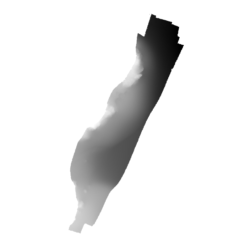
Multibeam bathymetry showing submarine terraces in the seafloor southeast of Tvärminne Zoological Station in southern Finland archipelago. Detailed information about the depth and shape of the seafloor is provided by the acquired multibeam bathymetry. This information is commonly used to study, for example, general seafloor geology, glacial morphology, bottom habitats, and bottom current activities.
|
|
Citation proposal
Stockholm University, Department of Geological Sciences. SDN_CPRD_4720_Tvarminne. https://services.mspdata.eu:/geonetwork/srv/api/records/SDN_CPRD_2210_Tvarminne |
Simple
- Alternate title
- Date ( Creation )
- 2020-01-02
- Date ( Revision )
- Identifier
- Tvarminne
Originator
Stockholm University, Department of Geological Sciences
Svante Arrhenius vag 8
Stockholm
106 91
Sweden
- Website
- web site
Custodian
Stockholm University, Department of Geological Sciences
Svante Arrhenius vag 8
Stockholm
106 91
Sweden
- Website
- web site
- Project name ( Theme )
-
- EMODNet Bathymetry
- SeaDataNet device categories ( Theme )
-
- multi-beam echosounders
- http://vocab.ndg.nerc.ac.uk/ ( Stratum )
-
- Parameter Discovery Vocabulary (P02) ( parameter )
-
- Bathymetry and Elevation
- GEMET - INSPIRE themes, version 1.0 ( Theme )
-
- Hydrography
- SeaDataNet depth measurement reference planes ( Theme )
-
- mean sea level
- Use limitation
- Access constraints
- Creative Commons Attribution 4.0 International
- Use constraints
- Creative Commons Attribution 4.0 International
- Other constraints
- Use limitation
- Spatial representation type
- Grid
- Denominator
- 10000
- Distance
- 0.5 meter
- Metadata language
- English
- Character set
- UTF8
- Topic category
-
- Oceans
N
S
E
W
))
- Unique resource identifier
- Description
-
Map projection parameters, values and units :
Axes units :
- Unique resource identifier
- Codespace
- EPSG
- Version
- 7.4
- Reference system identifier
- EPSG / EPSG:32634 / 7.4
- Number of dimensions
- 3
- Dimension name
- Column
- Dimension size
- 1344
- Dimension name
- Row
- Dimension size
- 1376
- Dimension name
- Time
- Dimension size
- 1
- Resolution
- 1 minute
- Cell geometry
- Point
- Transformation parameter availability
- false
- Checkpoint Availability
- false
- Point in Pixel
-
- Center
- Distribution format
-
-
GeoTIFF
(1.0 )
- Specification
-
GeoTIFF
(1.0 )
Distributor
Stockholm University, Department of Geological Sciences
Svante Arrhenius vag 8
Stockholm
106 91
Sweden
- Website
- web site
- Transfer size
- 2
- Protocol
- WWW:LINK
- Name
- Description
- Function
- Information
- OnLine resource
- EMODnet Bathymetry WMTS service
- Hierarchy level
- Dataset
Vertical extent
- Minimum value
- -8
- Maximum value
- -42
Vertical CS
Vertical datum
- Statement
- no information
- Hierarchy level
- Feature
- Dataset
- accuracy
Gridded data positional accuracy
- Name of measure
- horizontal accuracy
- Measure identification
- horizontal accuracy of coordinate
- Measure description
- Evaluation method description
Quantitative result
- Value type
- horizontal accuracy
Quantitative attribute accuracy
- Name of measure
- depth
- Measure identification
- depth accuracy
- Measure description
- Evaluation method description
Quantitative result
- Value
- not defined
Conformance result
- Date
- Explanation
- Pass
- false
- Hierarchy level
- Software
- Description
- Other
- software
- Hierarchy level
- Property type
- Description
- parameters of data processing
- Attributes
- Statement
- The multibeam bathymetry is provided in the form of a compiled Digital Terrain Model with a cell-spacing of 50x50 cm. The processing of the raw data was carried out using the Qimera software by QPS.
- Description
- The data were acquired with Stockholm University research vessel (RV) Electra in 2017 under Finnish survey permission granted to Tvärminne Zoological Station. The multibeam bathymetry was here collected for the purpose of providing a geospatial framework for habitat studies in the Tvärminne area within The Baltic Bridge initiative, a collaboration project between Stockholm University and Tvärminne Zoological Station, Helsinki University.
- Hierarchy level
- Dataset
Absolute external positional accuracy
- Name of measure
- emodnet-bathymetry.QI.Horizontal
- Value
- 3 - < 20 m
Absolute external positional accuracy
- Name of measure
- emodnet-bathymetry.QI.Vertical
- Value
- 4 - MBES High frequency (higher that 100kHz) (1+0.5%d)
Domain consistency
- Name of measure
- emodnet-bathymetry.QI.Purpose
- Value
- 2 - Bathymetric
Metadata
- File identifier
- SDN_CPRD_2210_Tvarminne XML
- Metadata language
- English
- Character set
- UTF8
- Hierarchy level name
- Product record
- Date stamp
- 2024-04-04T12:22:59.733Z
- Metadata standard name
- ISO 19115:2003/19139 - EMODNET - BATHYMETRY
- Metadata standard version
- 1.0
Author
Stockholm University, Department of Geological Sciences
Svante Arrhenius vag 8
Stockholm
106 91
Sweden
- Website
- web site