Metadata catalogue
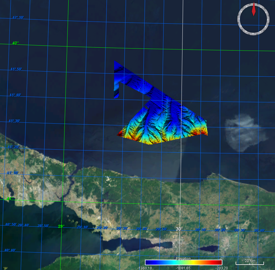
Grid extracted from GMRT Map Tool for the BlackSea region
Ryan, W.B.F., S.M. Carbotte, J.O. Coplan, S. O'Hara, A. Melkonian, R. Arko, R.A. Weissel, V. Ferrini, A. Goodwillie, F. Nitsche, J. Bonczkowski, and R. Zemsky (2009), Global Multi-Resolution Topography synthesis, Geochem. Geophys. Geosyst., 10, Q03014, doi: 10.1029/2008GC002332
Extraction of the GMRT grid for the Black Sea region of EMODnet bathymetry.
GMRT overview from https://www.gmrt.org/about/index.php
The Global Multi-Resolution Topography (GMRT) Synthesis is a multi-resolution Digital Elevation Model (DEM) maintained in three projections and managed with a scalable global architecture that offers infrastructure for accessing the DEM as grids, images, points and profiles. A mask layer is available that highlights the location of high-resolution data. Most curatorial effort for GMRT is focused on cleaning and processing ship-based multibeam sonar data acquired by the US Academic Research Fleet (ARF) so they can be gridded at their full spatial resolution (~100m in the deep sea). These data are seamlessly overlain on lower resolution observed and predicted bathymetry data and are integrated with terrestrial elevation data to deliver to users the best resolution data that have been curated for a particular area area of interest.
|
|
Citation proposal
Lamont-Doherty Earth Observatory, Columbia University. Grid extracted from GMRT Map Tool for the BlackSea region. https://services.mspdata.eu:/geonetwork/srv/api/records/SDN_CPRD_1384_GMRT2024_BlackSea |
Simple
- Alternate title
- Date ( Creation )
- 2024-06-05
- Date ( Revision )
- Identifier
- GMRT2024_BlackSea
Originator
P.O. Box 1000
61 Route 9W
Palisades 10964-1000 United StatesCustodian
P.O. Box 1000
61 Route 9W
Palisades 10964-1000 United States- Project name ( Theme )
-
- SeaDataNet device categories ( Theme )
-
- multi-beam echosounders , single-beam echosounders
- http://vocab.ndg.nerc.ac.uk/ ( Stratum )
-
- Parameter Discovery Vocabulary (P02) ( parameter )
-
- Bathymetry and Elevation
- GEMET - INSPIRE themes, version 1.0 ( Theme )
-
- Hydrography
- SeaDataNet depth measurement reference planes ( Theme )
-
- sea level
- Use limitation
- Access constraints
- unrestricted
- Use constraints
- academic
- Other constraints
-
Citation
Ryan, W.B.F., S.M. Carbotte, J.O. Coplan, S. O'Hara, A. Melkonian, R. Arko, R.A. Weissel, V. Ferrini, A. Goodwillie, F. Nitsche, J. Bonczkowski, and R. Zemsky (2009), Global Multi-Resolution Topography synthesis, Geochem. Geophys. Geosyst., 10, Q03014, doi: 10.1029/2008GC002332
- Use limitation
- Spatial representation type
- Grid
- Denominator
- 50000
- Distance
- 3.75 Arc second
- Metadata language
- English
- Character set
- UTF8
- Topic category
-
- Oceans
))
- Unique resource identifier
- Description
-
Map projection parameters, values and units :
Axes units :
- Unique resource identifier
- Codespace
- EPSG
- Version
- 7.4
- Reference system identifier
- EPSG / WGS 84 (EPSG:4326) / 7.4
- Number of dimensions
- 3
- Dimension name
- Column
- Dimension size
- 976
- Dimension name
- Row
- Dimension size
- 504
- Dimension name
- Time
- Dimension size
- 1
- Cell geometry
- Point
- Transformation parameter availability
- false
- Checkpoint Availability
- false
- Point in Pixel
-
- Distribution format
-
-
NetCDF
( )
- Specification
-
NetCDF
( )
Distributor
Distributor
- Protocol
- WWW:LINK
- Name
- Description
- Function
- Information
- OnLine resource
- EMODnet Bathymetry WMTS service
- Hierarchy level
- Dataset
Vertical extent
- Minimum value
- 205
- Maximum value
- 1960
Vertical CS
Vertical datum
- Statement
- no information
- Hierarchy level
- Feature
- Dataset
- accuracy
Gridded data positional accuracy
- Name of measure
- horizontal accuracy
- Measure identification
- horizontal accuracy of coordinate
- Measure description
- Evaluation method description
Quantitative result
- Value type
- horizontal accuracy
Quantitative attribute accuracy
- Name of measure
- depth
- Measure identification
- depth accuracy
- Measure description
- Evaluation method description
Quantitative result
- Value
- not defined
Conformance result
- Date
- Explanation
- Hierarchy level
- Software
- Description
- Other
- software
- Hierarchy level
- Property type
- Description
- parameters of data processing
- Attributes
- Statement
-
Description of data processing :
https://www.gmrt.org/about/index.php
How are swath data processed?
We use a combination of software developed in-house and open source software to process swath data for GMRT. MB-System provides the backbone of the code that we use for our data cleaning and processing. Raw multibeam sonar ping files available for each cruise are first run through a series of crude filters (e.g. ocean depth), and are then used to generate a development set of 100-m resolution tiled images and grids. These images and grids are reviewed and quantitatively interrogated using a custom version of GeoMapApp. This allows our team to assess data coverage and data quality, and to identify problems in the data that can be addressed using multibeam processing tools and techniques available through MB-System.
Data are typically processed to 100-m resolution. While our overall goal is to include only high-quality data, we sometimes include lower quality data in areas where data coverage is sparse (e.g. Southern Ocean). The data are reviewed, edited as necessary and re-gridded iteratively until the quality is suitable for inclusion in the tile set. During this process, we also determine the maximum data resolution for the cruise, the data are either gridded at 100m (default), 50m, and 25m resolution depending on sonar system capabilities and survey area. The chosen resolution is applied to the entire cruise and is therefore limited by maximum water depth. During QA/QC we also assign a quality value to the cruise on the range of 1-10 with 10 being applied to the highest quality cruises. This value is applied to the data and affects the degree of blending that happens when the data are merged into the compilation.
After extraction from the GMRT website, the grid is converted in the specified format of the EMODnet Bathymetry project before integration.
- Description
-
Multisources bathymetry
Data sources for GMRT grid is described in https://www.gmrt.org/contributors/index.php
- Hierarchy level
- Dataset
Absolute external positional accuracy
- Name of measure
- emodnet-bathymetry.QI.Horizontal
- Value
- 1 - Between 500m and 50m
Absolute external positional accuracy
- Name of measure
- emodnet-bathymetry.QI.Vertical
- Value
- 2 - MBES low frequency (lower than 100kHz) (similar than 1+2%d)
Domain consistency
- Name of measure
- emodnet-bathymetry.QI.Purpose
- Value
- 0 - Undefined
Metadata
- File identifier
- SDN_CPRD_1384_GMRT2024_BlackSea XML
- Metadata language
- English
- Character set
- UTF8
- Hierarchy level name
- Product record
- Date stamp
- 2024-06-05T14:04:03.254Z
- Metadata standard name
- ISO 19115:2003/19139 - EMODNET - BATHYMETRY
- Metadata standard version
- 1.0
Author
IFREMER Centre de Bretagne
ZI Pointe du diable
CS 10070
PLOUZANE 29280 France- Name
- web site
- Function
- Information