 Metadata catalogue
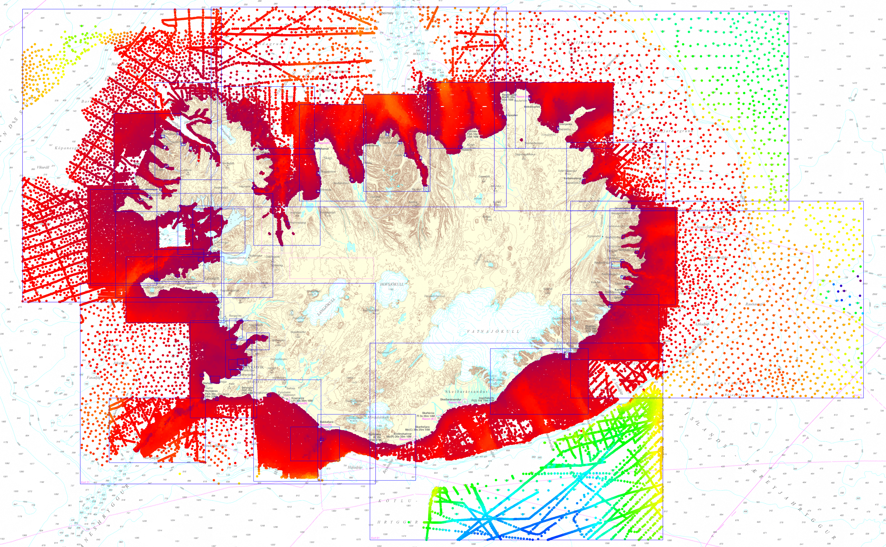
Iceland 2019 Bathymetric Dataset
Depth data extracted from Icelandic Coast Guard Hydrographic Survey dataset which Icelandic charts are compiled from. The dataset is made up of CARIS Editor chart files for all Icelandic charts (mid-year 2019). The depth data is at various resolutions and originates from both single beam surveys starting from 1930 to latest multibeam surveys.
|
|
Citation proposal
Icelandic Coast Guard Hydrographic Department. Iceland 2019 Bathymetric Dataset. https://services.mspdata.eu:/geonetwork/srv/api/records/SDN_CPRD_1112_ISL2019 |
Simple
- Alternate title
- Date ( Creation )
- 2019-06-21
- Date ( Revision )
- Identifier
-
ISL2019
Originator
Custodian
Originator
- Project name ( Theme )
-
- SeaDataNet device categories ( Theme )
-
-
single-beam echosounders
,multi-beam echosounders
-
- http://vocab.ndg.nerc.ac.uk/ ( Stratum )
-
- Parameter Discovery Vocabulary (P02) ( parameter )
-
-
Bathymetry and Elevation
-
- GEMET - INSPIRE themes, version 1.0 ( Theme )
-
-
Hydrography
-
- SeaDataNet depth measurement reference planes ( Theme )
-
-
mean low water springs
-
- Use limitation
- Access constraints
- License
- Use constraints
- Copyright
- Other constraints
- Use limitation
- Spatial representation type
- Grid
- Metadata language
- English
- Character set
- UTF8
- Topic category
-
- Oceans
))
- Unique resource identifier
- Description
-
Map projection parameters, values and units :
Axes units :
- Unique resource identifier
- Codespace
-
EPSG
- Version
-
7.4
- Reference system identifier
-
EPSG
/WGS 84 (EPSG:4326)
/7.4
- Number of dimensions
- 3
- Dimension name
- Column
- Dimension name
- Row
- Dimension name
- Time
- Dimension size
- 1
- Cell geometry
- Point
- Transformation parameter availability
- false
- Checkpoint Availability
- false
- Point in Pixel
-
- Distribution format
-
-
()
- Specification
-
()
Distributor
- Protocol
-
WWW:LINK
- Name
-
Árni Þór Vésteinsson
- Description
- Function
- Information
- Hierarchy level
- Dataset
Vertical extent
Vertical CS
Vertical datum
- Statement
-
no information
- Hierarchy level
- Feature
- Dataset
-
accuracy
Gridded data positional accuracy
- Name of measure
-
horizontal accuracy
- Measure identification
-
horizontal accuracy of coordinate
- Measure description
- Evaluation method description
Quantitative result
- Value type
- horizontal accuracy
Quantitative attribute accuracy
- Name of measure
-
depth
- Measure identification
-
depth accuracy
- Measure description
- Evaluation method description
Quantitative result
- Value
- not defined
Conformance result
- Date
- Explanation
- Hierarchy level
- Software
- Description
- Other
-
software
- Hierarchy level
- Property type
- Description
-
parameters of data processing
- Attributes
- Statement
-
Description of data processing :
- Description
-
Description of processed data sources :
- Hierarchy level
- Dataset
Absolute external positional accuracy
- Name of measure
-
emodnet-bathymetry.QI.Horizontal
- Value
- -1 - Multisources
Absolute external positional accuracy
- Name of measure
-
emodnet-bathymetry.QI.Vertical
- Value
- -1 - Multisources
Domain consistency
- Name of measure
-
emodnet-bathymetry.QI.Purpose
- Value
- 3 - Hydrographic survey or compatible with hydrographic standards
Metadata
- File identifier
- SDN_CPRD_1112_ISL2019 XML
- Metadata language
- English
- Character set
- UTF8
- Hierarchy level name
-
Product record
- Date stamp
- 2022-08-05T10:44:48.876Z
- Metadata standard name
-
ISO 19115:2003/19139 - EMODNET - BATHYMETRY
- Metadata standard version
-
1.0
Author
Author
Overviews
Provided by
